Accessibility Guidebook for Outdoor Recreation and Trails
August 2012
1223-2806P-MTDC
Janet Zeller, National Accessibility Program Manager
Ruth Doyle, Cibola National Forest Recreation, Engineering,
Archaeology, Lands, and Minerals Staff Officer
Kathleen Snodgrass, Project Leader
The National Forests provide opportunities for all sorts of outdoor recreation in some of the loveliest settings on the planet.
Acknowledgments
During the revision of this document, the authors worked closely with the staff of the U.S. Access Board and would like to thank them for their cooperation. The U.S. Access Board is an independent Federal agency devoted to accessibility for people with disabilities. About 30 employees and a governing board of representatives from Federal Departments and public members appointed by the President have these key responsibilities:
-
Developing and maintaining accessibility requirements for the built environment, transit vehicles, telecommunications equipment, and electronic and information technology
-
Providing technical assistance and training on these guidelines and standards
-
Enforcing accessibility standards for federally funded facilities
The authors deeply appreciate the contributions of the following people who provided advice and information for this updated version:
-
Christopher Douwes, Federal Highway Administration
-
Bill Botten, U.S. Access Board
-
Peter Jensen, Peter S. Jensen Associates, LLC
-
Jaime Schmidt, Forest Service
The authors would like to express their grateful appreciation for the contributions of these individuals and organizations: Forest Service employees Carl R. Bauer, Nancy Brunswick, Jasmine Budrow, Mark Conn, Donna Graham, Barth Hamberg, Maureen Hanson, Dave Hatch, Kay Hopkins, Alison Koopman, Katrina Kuchenbecker, David Kuykendall, Donna Marks, Ann May, Iran Martinez, Douglas Reeves, Jan Spencer, Jim Steward, Ron Vance, Mike VanHorn, Brian Williams, James Wyatt, and Lois Ziemann provided photographs or sketches for this version, as well as Mary Watne, MT; Axess Outdoors, MT, http://www.axessoutdoors.com; Jamestown Advanced Products Corporation, NY, http://www.jamestownadvanced.com; Northeast Passage, NH, http://www.nepassage.org; Trac About, Inc., KS, http://www.tracabout.com; and Disabled Sports USA, MD, http://www.dsusa.org.
ETA Editor's Note
The links to Disabled Sports USA and Axess Outdoors as shown above in the original document, are no longer valid links. Disabled Sports USA is now located here: http://www.disabledsportsusa.org/. However, "Axess Outdoors" does not show any results in an internet search.
The authors thank the Missoula Technology and Development Center (MTDC) publications and support staff who created an attractive and easy-to-read report: Geraldine Wolf, Sunni Bradshaw, Claudia Ruple, and Amanda Determan. The authors are grateful for the informative illustrations produced by Deb Mucci.
Introduction
This publication is an updated version of the original "Accessibility Guidebook for Outdoor Recreation and Trails" (2006 edition). The original guidebook was released the same day the U.S. Department of Agriculture (USDA), Forest Service accessibility guidelines were finalized as the legal standard for the agency. At that time, the Outdoor Developed Areas Accessibility Guidelines (ODAAG) under the Architectural Barriers Act were still under development by the U.S. Access Board.
Now that ODAAG has been finalized, the 2006 Forest Service Outdoor Recreation Accessibility Guidelines (FSORAG) and Forest Service Trail Accessibility Guidelines (FSTAG) have been revised and streamlined, incorporating the applicable sections of ODAAG. FSORAG and FSTAG look much the same as they did before revision and are still individual documents that integrate universal design, as well as agency terminology and processes. These guidelines are legally enforceable on National Forest System lands. While the guidelines are official policy only for the Forest Service, they contain useful concepts to help other agencies and organizations maximize accessibility without changing the setting in outdoor recreation areas and on trails.
This guidebook was written to help designers and managers apply FSORAG and FSTAG to their work and to provide guidance for integrating accessibility into outdoor recreation site and trail projects. When recreation professionals understand what is needed, accessibility becomes integrated into the thinking, planning, designing, construction, and maintenance of every project from the beginning. Accessibility always is more difficult and costly to implement as an afterthought. Forest Service direction is to integrate accessibility from the start of each project.
Continued coordination among Forest Service employees and with partners is essential to successfully implement FSORAG and FSTAG. The Forest Service is committed to incorporating FSORAG and FSTAG into National Forest System projects and ensuring inclusive outdoor recreation opportunities.
The Outdoors Are for Everyone—Fundamentals of Outdoor Recreation and Trails Accessibility
It's all about people having the opportunity to enjoy the outdoors. Public lands offer a wide range of recreation settings and opportunities from highly developed campgrounds to untouched wilderness areas. Visitors may choose both the type of recreation they want to pursue and where to pursue it. Of course, recreationists must always check to make sure that what they want to do is allowed where they want to recreate.
Why Accessibility Is Important
The Forest Service is committed to integrating and maximizing accessibility into the full range of recreation opportunities while protecting natural resources and maintaining the character and experience of the settings so that all people have the opportunity to enjoy the great outdoors. This commitment is established in Forest Service policy.
How does accessibility fit into this range of opportunities? We certainly don't want to pave the wilderness. However, when the decision is made to construct or alter a building, trail, recreation site, or other facility, we must ask, "How can we design, purchase, or build it to ensure all people have an equal opportunity to use this facility?" The key is to ask this question before the facility has been designed and built or purchased. Then we can provide facilities for use by all people.
For more information on Forest Service recreation opportunities, visit http://www.fs.fed.us/recreation/.
How many people benefit from accessible facilities? At the time of the 2010 census, 54 million people (about 1 in every 5 people in the United States) had a disability that significantly limited one or more major life activities, such as walking, seeing, hearing, breathing, and thinking. Of that number, 7 percent used wheelchairs, and 2.1 percent used crutches, canes, walkers, or other assistive devices. Seventy-five percent have disabilities that are not obvious at first glance. People with disabilities constitute the largest minority in the country.
Additionally, the population of the United States is aging. By the year 2030, more than 80 million people will be 65 or older. As people age, impairments are more likely to hinder activities. If you live long enough, you are likely to join the ranks of people with disabilities.
Recreation Opportunities on National Forests and Grasslands
There are national forest and grasslands in all but six of the States and in Puerto Rico and the Virgin Islands.
-
155 national forests and grasslands
-
193 million acres (78.1 million hectares) to enjoy
-
-
439 congressionally designated wilderness areas
-
37.6 million acres (15.2 million hectares) in which to experience solitude and a pristine environment
-
-
156,000 miles (251,000 kilometers) of trails to hike
-
122 wild and scenic rivers
-
4,927 miles (7,929 kilometers) of beautiful water to float or fish
-
-
19,611 recreation sites and 23,000 recreation buildings
-
5,000 campgrounds in which to pitch a tent or set up a trailer or recreational vehicle
-
-
Thousands of miles (or kilometers) of scenic byways to drive
-
172 million visits each year
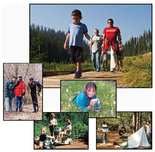
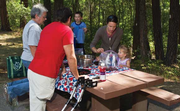
If anyone in a group has a disability, accessibility is an issue for the whole group (figure 1.) This influences where the group will go and what they will do together. Ski areas learned many years ago that each skier who has a disability is usually accompanied by three or four additional skiers who don't have disabilities. They all want to buy lift tickets, rent gear, eat lunch, and ski together. Accessibility is good customer service and good for business.
Figure 1—Although the Blackberry Crossing Campground in the White Mountain National Forest is not highly developed, it's a great place for this group of friends to enjoy camping together. Photo credit: Northeast Passage, Durham, NH
Just as recreational preferences vary among the general population, people with disabilities enjoy different types of outdoor recreation. We must make sure that facilities allow all visitors to choose their own recreational activities.
What Terminology Should Be Used?
Although people who have disabilities refer to themselves in many different ways and numerous "buzz words" have been used to describe people with disabilities over the years, direction for terminology was provided in the early 1990s. The 1990 Americans with Disabilities Act (ADA) uses the phrase persons with disabilities and the word accessible. When Section 504 of the Rehabilitation Act of 1973 was renewed and amended in 1992, its terminology was corrected to include accessible and persons with disabilities. Federal agency regulations, policies, and documents have used terminology that matches ADA and the Rehabilitation Act since that time.
A disability is a medically definable condition that causes a limitation in one or more of a person's major life activities, such as walking, seeing, hearing, speaking, breathing, thinking, and so forth. Person-first terminology is used because the person is more important than his or her disability. Examples include:
-
A person who is blind—not "a blind person"
-
A person who uses a wheelchair—not "a wheelchairbound person" or "a wheelchair person"
A handicap is a barrier or circumstance that makes progress difficult, such as a flight of stairs that may be impassable for a person using a wheelchair or a negative attitude toward a person who has a disability. The word "handicapped" has negative connotations and has been around for centuries, though it wasn't used to refer to people with disabilities until the late 1800s. Many people believe that "handicapped" was first used in relation to persons with disabilities when Civil War veterans (with injuries that prevented them from working) were begging on the streets with "cap in hand." Standard references do not support this story. But because the story has become legend and begging for a living is degrading, describing people with disabilities as "handicapped" is offensive to most people with disabilities. The word "handicapped" should be eliminated from vocabulary, publications, and other materials.
Disability Etiquette
-
Use common sense and extend common courtesy to everyone.
-
Don't patronize anyone; treat adults like adults.
-
Be patient. Some people need more time to express themselves or move about.
-
Relax and be yourself. It's okay to use common phrases such as "see you later" when talking with a person who is blind or has limited vision.
-
Speak directly to the person and maintain eye contact, don't speak through a companion or interpreter.
-
Use person-first terminology. Don't use words like handicapped, victim, or afflicted to describe a person who has a disability.
-
Offer assistance to persons with disabilities, wait for their response, and follow their specific directions.
-
Do not pet, feed, or distract service animals without first asking permission. They are working animals, not pets.
Accessible facilities comply with the accessibility guidelines and standards. A site, facility, or program is either accessible or it is not accessible. For instance, figure 2 illustrates one type of trail that complies with accessibility guidelines. The only way to evaluate accessibility is to evaluate the facility's compliance with the guidelines in effect at the time it was designed, constructed, or altered. There are no shades of accessibility. For instance, a parking space complies with the standards and is accessible, or it doesn't comply with the standards and is not accessible. The specific technical requirements of the standards for surfacing, slope, and the size of the parking space and walkway connection must be met, regardless of the conditions around the parking space.
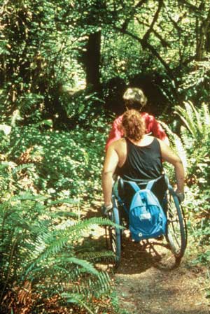
Figure 2—Two friends enjoy a trail that complies with the guidelines and allows them to hike through the rain forest.
Other phrases concerning accessibility that are not correct include: partially accessible, accessible with assistance, barrier free, ADA accessible, and handicapped accessible. A facility is either accessible or it is not accessible. If the facility is not accessible, the visitor or employee needs to know which specific areas are not accessible. "Partially accessible" and "accessible with assistance" imply some accessibility problems, but don't provide enough information to be helpful. "Barrier free" isn't legally defined or commonly understood. "ADA accessible" confuses laws with accessibility standards. "Handicapped accessible" is a common phrase, but it is offensive to many people with disabilities and should not be used. "Handicapped accessible" is also a contradiction because a handicap is a barrier and accessible means there aren't any barriers. The best terminology is simply accessible and not accessible.
Providing Appropriate Information About Accessibility
Forest Service policy is to provide nonjudgmental information about programs and facilities so that visitors may choose the areas, activities, and facilities that best meet their interests and needs. The goal is independence, integration, and dignity for all visitors.
-
When composing copy for Web sites, brochures, and other public information sources, consult with forest recreation staff or forest accessibility coordinators to ensure appropriate and accurate information is conveyed and displayed.
-
When describing a specific site or area, use the term accessible only if all facilities, constructed features, and connecting routes are in full compliance with the applicable accessibility guidelines. Accessible refers only to specific facilities, constructed features, or routes that have been constructed or altered in compliance with all of the requirements of the applicable accessibility guidelines. Electronic copies of these guidelines are available at http://www.fs.fed.us/recreation/programs/accessibility/.
-
Don't use the terms "ADA," "partially," "barrier free," or "handicapped."
-
-
Provide specific details about what people can expect to encounter. For instance, include minimum width, maximum slope, and condition of the tread surface (is it firm and stable?) on information about trails. All information is for all users.
-
Don't prejudge or assume what a person can or cannot do by adding comments such as "some people may need assistance," etc. These notes, even though well intended, are patronizing.
-
Don't assign accessibility-related difficulty levels to recreation opportunities, such as camping, boating, fishing, hiking, etc. Individuals will determine which opportunity best meets their interests and abilities after reviewing the specific information about that opportunity.
-
-
Whenever standard outdoor recreation symbols are used on maps and other information sources, use the color blue to indicate accessible units. For instance, if the tent symbol is used to show the location of campgrounds on an area map, the tent symbol indicating campgrounds with accessible units should be blue, but the tent symbol for campgrounds without accessible units should be a different color, such as brown. The legend for the map should include the information that blue indicates accessibility.
-
Don't use the international symbol of accessibility on information. This symbol only should be used on signs at six legally defined facility locations when they are in full compliance with the applicable accessibility guidelines: toilet, parking space, entrance if not the main entrance, loading zones, areas of refuge in a building, and route of egress out of a building. More information about use of the international symbol of accessibility is available in "Use of the International Symbol of Accessibility and Other Signs" of this guidebook.
-
-
On newly constructed or altered trails, whether the trail complies with the accessibility guidelines or not, include the following trail information, in addition to other information typically provided for hikers, on trailhead signs:
-
Destination and length of the trail or trail segment
-
Surface type
-
Typical and minimum tread width
-
Typical and maximum running slope
-
Typical and maximum cross slope
-
A statement that the posted information reflects the condition of the trail when it was constructed or assessed, including the date of the construction or assessment
-
Legal Requirements
The Architectural Barriers Act (ABA) became law in 1968. The act http://www.access-board.gov/the-board/laws/architectural-barriers-act-aba mandates that all facilities designed, built, altered, bought, rented, or leased by, for, or on behalf of a Federal agency must be accessible.
In 1973, the Rehabilitation Act became law. Section 504 http://www.dol.gov/oasam/regs/statutes/sec504.htm of the act applies to programs and activities that are conducted by Federal agencies and by entities that receive funding from, or operate under a permit from, Federal agencies. Section 504 requires that these programs and activities provide an equal opportunity for individuals with disabilities to participate in an integrated setting, as independently as possible. The only exception to the requirement is when the program would be fundamentally altered if changes were made solely for the purpose of accessibility. An example of a fundamental alteration to a program would be allowing use of a motor vehicle in an area not designated for motorized-vehicle use.
U.S. Department of Agriculture (USDA) implementation guidance for Section 504 is Title 7 of the Code of Federal Regulations, Part 15 (7 CFR 15) that was finalized in 1994. Subpart 15e http://www.access.gpo.gov/nara/cfr/waisidx_03/7cfr15e _03.html applies to programs conducted by the Forest Service. Subpart 15b http://www.access.gpo.gov/nara/cfr/waisidx_03/7 cfr15b_03.html applies to programs operating with Federal agency funding, under special use permits, or under other agreements with the agency. If a building or structure must be entered for someone to participate in the activity at the site, the building must be accessible.
The Americans with Disabilities Act (ADA) became law in 1990. Except for Title V, Section 508(c), ADA http://www.access-board.gov/the-board/laws/americans-with-disabilities-act-intro doesn't apply to Federal agencies' facilities and programs. Federal agencies were already required to be accessible under ABA and Section 504 of the Rehabilitation Act before ADA became law. ADA applies to State and local government services, to public accommodations such as motels and hotels, and to organizations that are open to the public. Title V, Section 508(c) of ADA applies to Federal wilderness areas. It reaffirms the 1964 Wilderness Act and clarifies that agencies aren't required to change the character of wilderness areas to provide accessibility. Section 508(c) also defines a wheelchair and states that wheelchairs meeting that definition may be used in Federal wilderness areas.
Universal Design
The best way to integrate accessibility is to use the principles of universal design. Universal design is simply designing programs and facilities to be usable by all people, to the greatest extent possible, without separate or segregated access for people with disabilities (figure 3). Using universal design principles is Forest Service policy, as stated in Forest Service Manual (FSM) 2330.3 These directives are available at http://www.fs.fed.us/im/directives/.
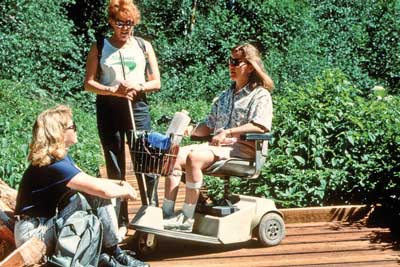
Figure 3— Friends enjoy a break during a stroll on a boardwalk through a wetlands area. A trail built on universal design principles makes it possible for a whole group to enjoy the same experience.
Since the early 1990s, the Forest Service has followed the universal design policy that all new and reconstructed facilities, programs, and associated elements are to be accessible to the greatest extent possible. This commitment often exceeds the minimum requirements of the Federal accessibility guidelines. The result of universal design is independence, integration, and dignity for everyone.
More information on accessibility guidelines is provided in the next part of this guidebook.
Program Accessibility
For the purposes of evaluating accessibility, a "program" is an activity in which people may participate. Basically, the program is the reason a person visits an area and may include opportunities such as:
-
Camping in a campground
-
Viewing the scenery at an overlook (figure 4)
-
Swimming at a beach
-
Enjoying solitude in the wilderness
-
Gathering information at a visitor center
-
Learning about an area on an interpretive trail
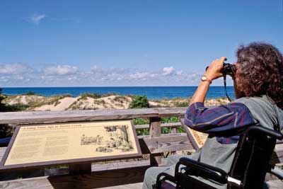
Figure 4—Interpretation is for everyone. Signs must be placed so that everyone can see and understand them.
The 1994 USDA regulations—7 CFR 15e http://www.access.gpo.gov/nara/cfr/waisidx_03/7cfr15e_03.html and 7 CFR 15b http://www.access.gpo.gov/nara/cfr/waisidx_03/7cfr15b_03.html govern USDA implementation of Section 504 of the Rehabilitation Act. They prescribe the requirements for ensuring access to programs.
If a program is provided inside a building or structure, everyone must be able to enter the facility to participate in the program. All facilities need to be constructed according to the applicable accessibility guidelines. Even historic structures are required to be as accessible as can be accomplished without destroying the historic significance of the structure. Unfortunately, some historic structures are not yet accessible, and a few cannot be made accessible without destroying their historic integrity. If a facility is not accessible, relocate the program or provide it in another manner (an alternative program). Any alternative program must allow everyone to participate together. Separate segregated programs just for people with disabilities aren't permitted. For example, if an evening program at a campground previously has been held in an amphitheater that isn't accessible, move the program to an accessible location until the amphitheater is accessible.
Under Section 504 of the Rehabilitation Act and 7 CFR 15, access to programs that don't depend on constructed facilities also are required to provide equal opportunity to all. People with disabilities may not be denied the opportunity to participate in a program if they meet the criteria to participate and their participation doesn't fundamentally alter the program. All participants must meet the essential eligibility criteria for the program and abide by any restrictions for that program in that area, including those of the forest land management plan. While all people are to have an equal opportunity to participate in programs and to strive to gain the same benefits offered by those programs, no guarantee of success is required.
The laws require equal opportunity; they don't require exceptional opportunity. For example, roads, trails, or other areas on national forests and grasslands that are not designated for motorized vehicle use under a forest travel management plan are closed to all motorized vehicles, including those used by people with disabilities.
Access to programs must be viewed through the lens of the entire program, not through the eyes of an individual. Access to the program is to be provided so long as doing so doesn't fundamentally alter the program. That is, providing access doesn't change the primary functions of the program. Allowing motor vehicles in a nonmotorized [sic] area would be a fundamental alteration of the recreation program for that area.
"Reasonable accommodation" does not apply to access to programs. Reasonable accommodation only applies in employment and involves making the modifications or adjustments to a job or the work environment so a specific qualified applicant or employee with a disability can participate in the application process or perform essential job functions. It does not apply to programs under Federal agencies, including recreation facilities and trails.
Questions often arise concerning the use of wheelchairs or other mobility devices in areas that restrict or prohibit mechanical devices or motorized vehicle use. As clarified in Title V, Section 508(c), the legal definition of a wheelchair is:
A device designed solely for use by a mobility–impaired person for locomotion that is suitable for use in an indoor pedestrian area
This is a two-part definition. "Designed solely to be used by a mobility-impaired person for locomotion" means that the wheelchair was originally designed and manufactured solely to be used for mobility by a person with a disability. The aftermarket retrofit of a motorized unit to make it usable by a person with a disability does not meet this part of the definition. The second part of the definition requires the device to be "suitable for use in an indoor pedestrian area" (figure 5). This means usable inside a home, courthouse, or other indoor pedestrian area, such as the food court of a mall.
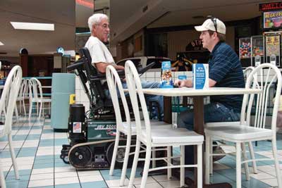
Figure 5—To meet the definition of a wheelchair, a device must be suitable for use in an indoor pedestrian area, such as this food court where two friends take a break from shopping. Like many wheelchairs, the device shown here also is useful for outdoor recreation, as shown in figure 11. Photo credit: Trac About, Inc., Newton, KS
The device must meet both parts of this definition in order for it to qualify as a wheelchair. Figures 6 through 11 show six examples of devices that meet the definition; figures 12 and 13 show two examples that do not.
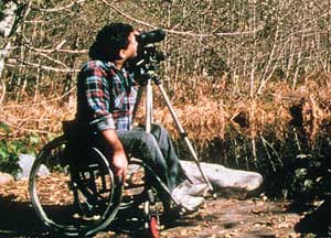
Figure 6
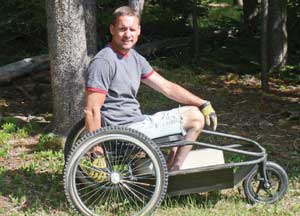
Figure 7—Photo credit: Axess Outdoors, Great Falls, MT
Figure 8
Figure 9
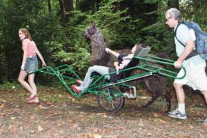
Figure 10
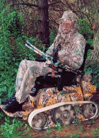
Figure 11—Photo credit: Trac About, Inc., Newton, KS
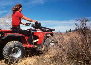
Figure 12
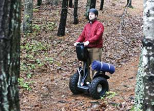
Figure 13
A person whose disability requires use of a wheelchair or mobility device may use a wheelchair or mobility device that meets both parts of the definition in the preceding paragraph anywhere foot travel is permitted in the National Forest System, in accordance with Title V, Section 508(c) of ADA; 36 CFR 212.1; and FSM 2353.05 and FSM 2320.05. Wheelchairs or mobility devices, including battery-powered wheelchairs that meet both parts of the definition, aren't categorized as motor vehicles or mechanical devices.
To determine whether a device meets the definition of a wheelchair, evaluate it against the two parts of the definition. Ask yourself the following questions:
1. Was the device designed solely for mobility by a person with a disability?
-
If "no," the device doesn't meet the definition and doesn't qualify for use as a wheelchair.
-
If "yes," ask the second question.
2. Is it suitable for use in an indoor pedestrian area? Consider whether it could be used in a mall, courthouse, or similar area without the security personnel directing the user to leave.
-
If "no," the device doesn't meet the definition and doesn't qualify for use as a wheelchair.
If the answer to both questions is "yes," the device meets the definition of a wheelchair or mobility device and may be used wherever foot travel is allowed. Some devices that don't meet both parts of the definition (see figures 12 and 13) are useful tools for some people with disabilities to move about in the outdoor environment, but they must follow the requirements for the appropriate class of motor vehicle. A "Motor Vehicle Use Map" that shows routes (roads and trails) and areas designated as open to motorized travel with allowed uses identified by vehicle class is available at national forest and national grassland offices. These maps also may be available through each forest or grassland's Web site http://www.fs.fed.us/ or through the National Forest Store Web site http://www.fs.fed.us/recreation/nationalforeststore/. Visitors can check the "Motor Vehicle Use Map" to learn where they may use devices that don't meet the definition.
Transition Plans
Since the 1968 passage of ABA, facilities designed, built, altered, bought, rented, or leased by, for, or on behalf of a Federal agency have been required to be accessible. Unfortunately, some Federal facilities are not yet accessible.
In the early 1990s, the Forest Service called for all units to complete transition plans identifying the changes needed to make each facility accessible and the timeline for completing those changes. Funding to complete the transition plans was provided to the regions in 1992, 1993, and 1994.
The regulation requiring transition plans for the existing facilities of all USDA agencies is 7 CFR 15e, section 150 "Program Accessibility: Existing Facilities." It requires a transition plan to be developed and implemented for any facility housing a program that is not accessible. The regulation required transition plans to be completed by December 31, 1997. Section 150(d) of 7 CFR http://www.access.gpo.gov/nara/cfr/waisidx_03/7cfr15e_03.html details the specific requirements for transition plans and their contents.
The transition plans covering many Forest Service areas were completed up to 20 years ago. The filed hard copies have been difficult to update and cannot be effectively entered into the National Resource Manager database that was later developed. To assure that their transition plans are current, Forest Service units are now resurveying facilities and recreation sites and recording the results electronically so that the database will contain accurate, current information.
Terminology Tip
Why wheelchairs are not motor vehicles.
In Title 36 of the Code of Federal Regulations, Part 212.1, a motor vehicle is defined as any vehicle that is self-propelled, other than:
-
A vehicle that is operated on rails
-
Any wheelchair or mobility device, including one that is battery powered, that is designed solely for use by a mobility-impaired person for locomotion, and that is suitable for use in an indoor pedestrian area
Wheelchairs that meet this legal definition may be used anywhere foot travel is allowed within the National Forest System. Mobility devices that do not meet this definition are considered to be motor vehicles within the National Forest System and may only be used where that class of motor vehicle is allowed.
No standardized format was provided in the regulation for the transition plans. Each region and some national forests developed their own transition plan format. Check with your accessibility coordinator or your regional recreation accessibility coordinator http://www.fs.fed.us/eng/toolbox/acc/documents/coord.htm#leaders or http://fsweb.mtdc.wo.fs.fed.us/toolbox/acc/documents/coord.htm (available only to Forest Service employees) or your region/station facilities program leader http://fsweb.wo.fs.fed.us/eng/documents/fac_leaders.htm (available only to Forest Service employees) to find out whether your local unit has developed a format. If not, request a sample of the formats used by other units. At a minimum, the transition plan must include:
-
A list of obstacles to accessing the facility and program as identified in the accessibility evaluation survey
-
A detailed description of the methods that will be used to provide accessibility
-
The schedule for implementing the plan, including the actions that will be taken each year if the work takes more than a year
-
The signature of the official responsible for implementation of the transition plan
Ensure transition plans are available to the public.
Accessibility Evaluation Surveys
During an accessibility evaluation survey, compare each portion of a structure to the accessibility standards, and record compliance and deficiencies. For example, check doorways to see whether they have at least 32 inches (815 millimeters) of clear width (figure 14). This information is important for developing transition plans and for providing useful information about the wide range of Forest Service facilities.
Figure 14—All doorways must have a minimum of 32 inches (815 millimeters) clear width.
A U.S. Forest Service Accessibility Database has been developed to facilitate the gathering, retention, updating, and use of the survey information. Check with your unit's accessibility coordinator or your regional recreation accessibility coordinator for more information about this database and about opportunities to have the accessibility of the recreation facilities on your unit surveyed. The Youth Conservation Corps Inclusive Toolbox Project offers one way to have surveys conducted and the resulting data entered into the accessibility database.
Applying Accessibility Guidelines to Your Site
How did we end up with so many accessibility guidelines and standards? Which guidelines and standards apply to your site? The following information will demystify accessibility guidelines and standards.
The History of Accessibility Guidelines
As explained earlier in this guidebook, accessibility laws have been enacted and updated since 1968. Here is a brief history of the guidelines for buildings, recreation facilities, and trails:
-
American National Standards Institute (ANSI)— 1969 to 1980. The first accessibility guidelines used by Federal agencies under the Architectural Barriers Act (ABA).
-
General Services Administration Accessibility Guidelines—1980 to 1984. The General Services Administration (GSA) developed its own set of guidelines for all buildings other than those of the U.S. Department of Housing and Urban Development, the U.S. Department of Defense, or the U.S. Postal Service. Those agencies developed their own guidelines.
-
Uniform Federal Accessibility Standards (UFAS)— 1984 to 2006. These standards updated and expanded the GSA accessibility guidelines. The standards were adopted under ABA and applied to all federally funded facilities, unless there was a higher standard of accessibility for that type of structure required by other legal standards or guidelines.
-
Americans with Disabilities Act Accessibility Guidelines (ADAAG)—1991 to 2010. ADAAG explains how to apply the Americans with Disabilities Act (ADA) of 1990 in the built environment. These guidelines apply to services provided by State and local governments, and public accommodations, such as motels and hotels.
-
Americans with Disabilities Act/Architectural Barrier Act Accessibility Guidelines (ADA/ABAAG) of 2004. Issued by the U.S. Access Board, these guidelines were developed as a merger and update of UFAS and ADAAG requirements. Chapters 1 and 2 contain application, administration, and scoping requirements. The 100 and 200 series apply only to those entities covered by ADA, (State and local government entities and private entities open to the public) and are NOT for Federal agency use. The F100 and F200 series apply only to facilities constructed by, for, or on behalf of Federal agencies. Chapters 3 through 10 provide the technical specifications that apply to all entities, unless the State or Federal agency has its own accessibility guidelines that are an equal or higher standard.
-
Architectural Barriers Act Accessibility Standards (ABAAS) of 2006. The GSA, standard-setting agency for Forest Service facilities, adopted the ABA portion of ADA/ABAAG as the standard for all agencies under its standard-setting jurisdiction. The new ABAAS replaced UFAS.
-
ADA Standards for Accessible Design (ADASAD) of 2010. The U.S. Department of Justice adopted the ADA portion of ADA/ABAAG for use by State and local government entities and private entities open to the public. ADASAD is effective as of March 15, 2012.
-
Outdoor Developed Areas Accessibility Guidelines (ODAAG) of 2012. The U.S. Access Board developed ODAAG as a component of ADA/ABAAG. It contains accessibility guidelines for outdoor developed recreation areas and trails that are federally funded. Federal agencies may develop and use their own guidelines only if they are an equal or higher standard.
-
Forest Service Outdoor Recreation Accessibility Guidelines (FSORAG) and Forest Service Trail Accessibility Guidelines (FSTAG), 2012 Updates. These guidelines are an equal or higher standard than ODAAG for outdoor recreation facilities and trails on the National Forest System. These guidelines must be used for the design, construction, alteration, purchase, or replacement of recreation sites, facilities, constructed features, and trails that meet FSTAG criteria on the National Forest System (FSM 2330 and FSM 2350).
Current Accessibility Guidelines That Apply to the Forest Service
The Forest Service and those working with or for the Forest Service on National Forest System land must comply with the following enforceable guidelines and standards when designing, constructing, or altering any facility or component addressed by those standards on National Forest System land.
Architectural Barriers Act Accessibility Standards (ABAAS). Forest Service drinking fountains, toilet facilities, parking lots and spaces, cabins, and administrative buildings are among the components covered by ABAAS. The complete ABAAS is available at http://www.access-board.gov/guidelines-and-standards/buildings-and-sites/about-the-aba-standards/aba-standards.
Forest Service Outdoor Recreation Accessibility Guidelines (FSORAG) and Forest Service Trail Accessibility Guidelines (FSTAG). These guidelines must be used for the design, construction, alteration, purchase, or replacement of recreation sites, facilities, constructed features, and trails on the National Forest System. The complete FSORAG and FSTAG are available at http://www.fs.fed.us/recreation/programs/accessibility/.
Table 1 shows examples of different facilities that are covered by ABAAS, FSORAG, and FSTAG.
Table 1—Accessibility guidelines quick guide (which accessibility guidelines apply where).
| ABAAS | FSORAG (Apply only within National Forest System boundaries) |
FSTAG (Apply only within National Forest System boundaries) |
|---|---|---|
| Buildings, Boating, and Fishing | Recreation Site Features | Hiker and Pedestrian Trails |
|
All Buildings, including:
Building components such as:
Boating and fishing facilities, including:
|
New or reconstructed:
|
Trails that are new or altered and
and
or
|
What if the Guidelines Appear To Conflict With Each Other?
It may appear that some accessibility guidelines conflict with other guidelines or codes, or with the realities of the outdoor environment. Railings must be high enough to protect visitors from a drop off, but railings that high might limit the viewing opportunity for a person using a wheelchair. Which requirement takes priority? Trash receptacles are supposed to be accessible so that everyone can use them, but then how do we keep bears out? Handpumps are vital to drawing water in campgrounds where the water system isn't pressurized, but operating the long handle of the traditional pump requires more force and a longer reach than allowed by accessibility provisions. Roads that have restrictions or closures to use by motorized vehicles may be open to foot travel, so how can a road be gated or bermed to keep out vehicles but still allow access by a person using a wheelchair? When you are faced with these types of situations, stop and think carefully about the issues. The solution always comes back to ensuring safety, abiding by the regulations, and doing so in a manner that includes the needs of all people.
Railings—Guardrails, Handrails, and Safety
Accessibility never supersedes the requirements for safety. This issue most commonly arises at overlook areas, on viewing structures, and in similar locations. For safety, the International Building Code (IBC), http://www.iccsafe.org, section 1003.2.12 contains requirements for guardrail height and the spacing of rails where there is a drop off of 30 inches or more. These requirements provide opportunities for creative design and for managers and designers to think seriously about the level of development that is appropriate for the setting. The creativity challenge is to provide safety when designing the railing or structure adjacent to the drop off, while maximizing viewing opportunities. Methods of solving this challenge are discussed in "Viewing Areas" of this guidebook.
Reconsidering the level of development at a site may be another way to balance safety and accessibility issues. It may not always be appropriate to provide paths and interpretive signs. When signs indicate a scenic viewpoint and a pathway begins at the parking lot, visitors are likely to stop, pile out of their vehicle, and head down that pathway, often with the children running ahead. Because of the high level of development at the entrance to the pathway, visitors expect that the viewpoint will have a similar high level of development, including safety features. Development should be consistent at both ends of the pathway.
If the area isn't developed, such as a waterfall in the forest with no signs or constructed trail to it, it may not be appropriate to develop a viewpoint. Some scenic areas should remain natural so that people have the opportunity of adventure and solitude. The safety and accessibility requirements only apply when constructed features are added to the setting.
While the accessibility guidelines for outdoor recreation areas do not require handrails at stairs, consider the safety of the people using the stairs and the setting when deciding whether handrails are appropriate. What is the expected amount of use? The determination must be made on a case-by case basis. For example, a handrail might not be necessary where there are a few regularly spaced stairs to an individual camping unit. However, handrails on stairs in a high-traffic recreation site may be important for safe use of the stairs. If the decision is made to install handrails at a recreation site, consider how the appearance of over development can be avoided while providing for safe use of the stairs. Choose materials carefully; determine how many railings will be provided based on safety considerations rather than convention, and so forth. When it is determined handrails are needed for safety at a specific site in an outdoor recreation area, use the technical requirements for handrails located in ABAAS, section 505.
Terminology Tip
What's the difference between a guardrail, a handrail, and a grab bar?
The following explanations of terms are based on the International Building Code and the Architectural Barriers Act Accessibility Standards. Keep these explanations in mind and use them to communicate more effectively.
-
Guardrails protect people from dropoffs higher than 30 inches (760 millimeters). Guardrails must be at least 42 inches (1,065 millimeters) high. If the guardrail has openings that are less than 34 inches (865 millimeters) above the walking surface, they must be small enough to prevent a 4-inch (100-millimeter) sphere from passing through them (figure 15). Requirements for guardrails are detailed in the International Building Code, section 1003.2.12.
-
Handrails provide a steady support for persons who are going up or down stairs or inclines. Handrails must be between 34 inches (865 millimeters) and 38 inches (965 millimeters) above the walking surface and be easy to grip. Details about acceptable configurations for handrails are provided in the International Building Code, section 1003.3.3.11 and in the Architectural Barriers Act Accessibility Standards, section 505.
-
Grab Bars provide stability and allow people to use their arms to help them move short distances. The most common location for grab bars is in restrooms. The required locations of grab bars are explained in the Architectural Barriers Act Accessibility Standards, chapter 6. Details about grab bar configuration and attachment are provided in the Architectural Barriers Act Accessibility Standards, section 609 and in the International Building Code, chapter 11.
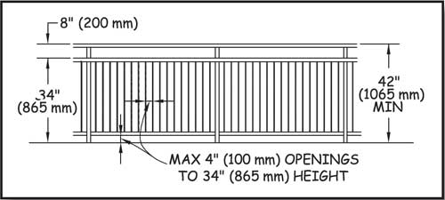
Figure 15— Dimensions required for guardrails.
Trash Receptacles and Wildlife
Safety is also the primary issue when it comes to the accessibility of trash receptacles. In bear country, use trash and recycling containers designed to keep the bears out to minimize contacts between bears and humans. Operating controls for these types of containers require more force than is allowed for accessible operation. Until bear-resistant trash and recycling containers that comply with the technical requirements for accessible operating controls are available from more than one source, recreation areas where bears and other large animals pose a risk to humans are exempt from this requirement. Incidentally, dumpsters—the big containers that are mechanically lifted and tipped to empty into commercial garbage trucks—are exempted from accessibility guidelines. More information about trash receptacles is in "Trash, Recycling, and Other Essential Containers" of this guidebook.
Handpumps and Water Systems
Handpumps also have been a concern (figure 16). Because of the piston-like pump mechanism, handpumps require a long reach. As the depth of the well increases, so does the force necessary to draw water, so most handpumps require a force greater than 5 pounds (2.2 newtons) to operate. An accessible handpump is now available for purchase. For shallower wells, this pump can draw the water while remaining in full compliance with the grasping, turning, and pressure restrictions of the accessibility guidelines (figure 17). More information about the new pump is available at http://www.fs.fed.us/recreation/programs/accessibility/. For wells with a static water depth of 40 feet (12 meters) or less, the accessible handpump can be used for many new or replacement installations. Accessible pumps for deeper wells are being developed and should be used when they become available. In the meantime, the accessibility requirements for handpump operating controls are under an exception explained in "Water Hydrants" of this guidebook.
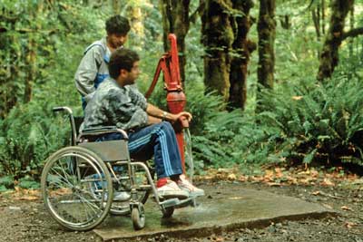
Figure 16—Not all campers can operate a standard handpump.
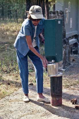
Figure 17—With an accessible handpump, the choice of who does the pumping is up to the campers.
Solar powered water systems (figures 18 and 19) are an excellent sustainable solution that can provide drinking water throughout the recreation season. In addition, a faucet that fully complies with the accessible operating control requirements can be used (figure 20). Even national forests in Northern States are having good success with their solar systems.
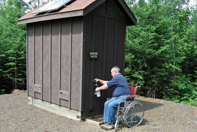
Figure 18—The water pump inside the pumphouse at Vermilion Falls Recreation Area on the Superior National Forest is powered by the solar panels on the roof. People can obtain drinking water without using a handpump at this site that has no electric service.
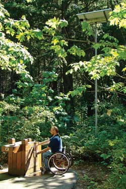
Figure 19—The water pumps for many campgrounds, such as this campground in the deep, narrow Icicle River Valley of the Okanogan-Wenatchee National Forest, can be housed in small pedestal enclosures and powered by solar panels on an adjacent pole. The pedestal enclosure also houses solar batteries.
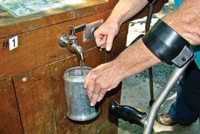
Figure 20—This water spigot is operated by first pushing the handle to one side, then pressing the push button. The water will stop when the button is no longer depressed.
Foot Travel on Trails and Roads With Restrictions
When gates, barriers, or berms are installed on a trail or a road to close it to motorized traffic or for other purposes, but foot travel is encouraged beyond the closure, people who use wheelchairs that meet the legal definition must be able to get behind the closure, as required by Section 504 of the Rehabilitation Act of 1973. As explained in "Program Accessibility" of this guidebook, a wheelchair is permitted anywhere foot travel is permitted.
When foot travel is encouraged beyond a closure, the Office of General Counsel of the U.S. Department of Agriculture has determined that a minimum of 36 inches (915 millimeters) of clear passage must normally be provided around or through the gate, berm, or other restrictive device (figures 21 and 22) to ensure that a person who uses a wheelchair can participate in the opportunity behind the restriction. This clear passage is required by the accessibility guidelines as explained in "Gates and Barriers" of this guidebook. Various methods can provide pedestrian passage around a restrictive device, but prevent passage by animals or vehicles that are not allowed beyond the gate or barrier. The Forest Service has developed designs for the tech tip "Accessible Gates for Trails and Roads." These gate designs can be locally constructed from materials appropriate to the setting. The plans are available at http://www.fs.fed.us/recreation /programs/accessibility/pubs/htmlpubs/htm06232340/index.htm and http://www.fhwa.dot.gov/environment/fspubs/.
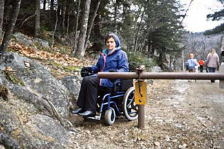
Figure 21—This road closure gate does not provide enough clearance to allow pedestrian passage.
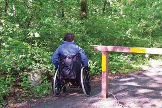
Figure 22—One way to get around a vehicle road closure gate: a paved bypass.
Indications that foot travel is encouraged include:
-
Destination signing
-
A pedestrian recreation symbol without a slash
-
A Forest Service map that highlights an opportunity behind the closure
-
A trail management objective or road management objective stating that pedestrian use is encouraged
In areas where foot travel isn't encouraged, but occasional pedestrian use is allowed before and after installation of the restriction device, work with individuals who use wheelchairs to determine the best solution.
Important Tools for Accessible Recreation
The following tools work together with the accessibility guidelines when accessible recreation facilities and programs are being developed and managed.
The "Built Environment Image Guide" (BEIG) provides guidance for improving the image, aesthetics, sustainability, and overall quality of the Forest Service's built environment. It emphasizes key elements to showcase the Forest Service's national identity and an image of quality and service. Within eight geographically defined architectural character types, BEIG emphasizes design that projects the overall Forest Service image while echoing local values, heritage, and culture. Use of BEIG contributes to an integrated approach to planning and design, including early collaboration among planners, designers, specialists, managers, and maintenance personnel.
The goal of BEIG is to influence the design, construction, and maintenance of buildings and other constructed features so they will:
-
Fit on the land
-
Reflect sensitive site planning and a concern for natural processes
-
Harmonize with the local landscape and climate
-
Incorporate the principles of sustainability as an integral part of their architectural character
-
Be accessible
-
Be durable and low maintenance
BEIG specifically requires use of universal design principles and points out that if universal design principles are applied to a site or facility design from the outset, they rarely, if ever, have any obvious effect on architectural character. When the principles of universal design are skillfully executed, facilities can still fit seamlessly within the natural and social environments. More information about BEIG is available at http://www.fs.fed.us/recreation/programs/beig/.
Recreation Opportunity Spectrum and Recreation Site Scale
Recreation Opportunity Spectrum (ROS) classifications provide guidance on the:
-
Amount of development that is acceptable at any given site
-
Amount of deviation from the site's natural characteristics that is appropriate during development
-
Types of materials that are appropriate for the setting
-
Typical recreation activities in each setting classification (figure 23)
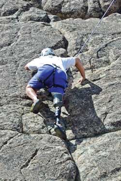
Figure 23—This free-style climber appears to enjoy the challenge, self-reliance, and independence characteristic of semi-primitive and primitive recreation opportunity spectrum settings. Photo credit: Disabled Sports USA, Rockville, MD
The spectrum assigns classifications of Urban, Rural, Roaded Natural, Semi-Primitive Motorized, Semi-Primitive Non-Motorized, and Primitive based on identified setting characteristics. Some units also include a Roaded Modified classification. Maps should be available at district or supervisor's offices showing ROS classification for the National Forest System lands administered by that unit. More information about ROS is available at http://www.fs.fed.us/cdt/carrying_capacity/rosfieldguide/ros_primer_and_field_guide.htm.
The amount of development at a site is described using a six-level recreation site planning development scale ranging from 0 (no site modification) to 5 (extensive site modification). Site modifications are provided for visitor convenience and comfort in recreation sites with characteristics meeting the criteria for scale level 3, 4, and 5. Rustic or rudimentary site modifications may be provided for resource protection at level 2 or less. Definitions of each level of the Forest Service's recreation site scale are included in the Forest Service Manual, Chapter 2330, exhibit 01.
Although neither ROS classifications nor the recreation site scale determine accessibility requirements, take both into account when designing site improvements. For instance, you may need improvements for resource protection in primitive and semi-primitive settings at recreation sites meeting the criteria for scale levels 1 or 2. In urban, rural, and roaded natural settings, you may want to provide improvements for visitor comfort and convenience at recreation sites meeting the criteria for scale levels 3, 4, or 5.
Wilderness Access Decision Tool
Details and implementation guidance for applying Title V, Section 507(c), the section of ADA that applies to Federal agencies and to the programs and facilities on federally managed lands, can be found at http://www.wilderness.net/index.cfm?fuse=toolboxes&sec=accessibility. Federal managers of wilderness areas can use this matrix to make appropriate, objective, and consistent decisions that meet the legal requirement to provide equal opportunity for all individuals, while ensuring no fundamental change to the wilderness experience for all individuals, in accordance with the 1964 Wilderness Act.
Appalachian Trail Conservancy's "Backcountry Sanitation Manual"
This comprehensive manual explains the basic issues of remote area sanitation, including health, aesthetics, and regulations, but it focuses on the construction and maintenance of moldering and composting toilets, and includes case studies and design plans. The "Backcountry Sanitation Manual" http://www.appalachiantrail.org/docs/trail-maintainers-corner/2011/04/14/backcountry-sanitation-manual.pdf is a cooperative project of the Green Mountain Club and the Appalachian Trail Conservancy.
Resolving problems of backcountry sanitation is a continuous challenge for trail clubs and land managers. This manual was created in the belief that all remote recreation areas will benefit from an expanded discussion of backcountry sanitation.
Pete Antos-Ketcham, Director of Operations, Green Mountain Club
Appalachian Trail Conservancy's "Increasing Opportunities for Access on the Appalachian Trail: A Design Guide"
Using the Forest Service's FSTAG and FSORAG, this design guide incorporates real-world Appalachian Trail examples as case studies that represent opportunities that can be used on other pedestrian trails. The guide's theme—universal design—transcends issues solely related to access for persons with disabilities by describing how universal design reduces resource damage and maintenance, saving money. The guide is available free of charge at http://www.appalachiantrail.org/docs/trail-maintainers-corner/increasing-opportunities-for-access-on-the-appalachian-trail-a-design-guide.pdf, (Appalachian Trail Conservancy 2007).
Accessibility Guidebook for Outfitters and Guides Operating on Public Lands
This guidebook contains a framework to help outfitters and guides who operate under a special-use permit from the Forest Service provide high-quality services for all visitors (figure 24). The guidebook addresses basic facility accessibility issues, but focuses primarily on program and activity accessibility. Outfitters and guides who operate businesses on public lands are governed by ADA because they are providing public accommodations and are also governed by Section 504 of the Rehabilitation Act because they are operating under special-use permits from Federal agencies. The guidebook identifies legal requirements and provides suggestions and practical tips for complying with ADA and Section 504 of the Rehabilitation Act. The guidebook is available at http://www.fs.fed.us/recreation/programs/accessibility/.
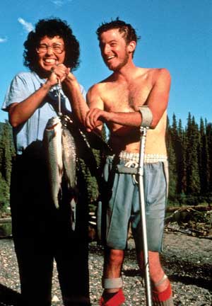
Figure 24—Outfitters and guides provide the logistics and support for visitors to enjoy a wide range of opportunities on national forests, including fishing.
Accessibility Guidebook for Ski Areas Operating on Public Lands
This guidebook provides a framework to help ski areas operating under special-use permits from the Forest Service better serve all visitors (figure 25). The guidebook addresses facility and program accessibility. Ski areas located on public lands are governed by ADA because they are providing public accommodations and also are governed by Section 504 of the Rehabilitation Act and related regulations because they are operating under special-use permits from a Federal agency. The guidebook includes legal mandates, suggestions, and practical tips for complying with laws and regulations and providing high-quality services. The guidebook is available at http://www.fs.fed.us/recreation/programs/accessibility/.
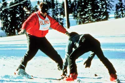
Figure 25—Ski areas that operate on public land must provide equal opportunity to access their services.
Cooperative Publications
The Federal Highway Administration (FHWA) cooperates with the Forest Service to provide Forest Service publications and videos to the public. Many publications are available at http://www.fhwa.dot.gov/environment/fspubs/index.htm in HTML and PDF (Acrobat) formats. Print copies for some publications can be ordered at http://www.fhwa.dot.gov/environment/rectrails/trailpub.htm.
Standard Forest Service National Trail Specifications
The engineering management publication "Standard Specifications for Construction and Maintenance of Trails" (EM–7720–103) provides a uniform set of specifications for contracted trail work throughout the Forest Service. Although these specifications do not address accessibility, they can be used in conjunction with FSTAG. The publication is available at http://www.fs.fed.us/database/acad/dev/trails/trails.htm.
Trail Construction and Maintenance Notebook
The Missoula Technology and Development Center's "Trail Construction and Maintenance Notebook" contains basic trail building information. It is available at http://www.fhwa.dot.gov/environment/fspubs/07232806/index.htm.
ETA Editor's Note
The above referenced "Trail Construction and Maintenance Notebook" is now located here: https://www.fhwa.dot.gov/environment/recreational_trails/publications/fs_publications/07232806/index.cfm
Although this document doesn't address accessibility, it is an important tool that you can use in conjunction with FSTAG during trail construction and planning.
Designing Sidewalks and Trails for Access
FHWA's "Designing Sidewalks and Trails for Access" is a two-part report on pedestrian accessibility, (Beneficial Designs Inc. 1999 and 2001).
-
Part 1, Review of Existing Guidelines and Practices (1999), lays out the history and the practices of applying accessibility concepts to sidewalks and pedestrian trails. This report is out of print and available only at http://www.fhwa.dot.gov/environment/sidewalks/index.htm.
-
Part 2, Best Practices Design Guide (2001), provides recommendations on how to design sidewalks, street crossings, intersections, shared-use paths, and recreational pedestrian trails. This report is out of print and available only at http://www.fhwa.dot.gov/environment/sidewalk2/index.htm.
-
A Transmittal Memorandum and an Errata Sheet are available at http://www.fhwa.dot.gov/environment/bikeped/guidance.htm#Access.
Accessibility guidelines and practices, as well as construction and maintenance techniques, have evolved since these reports were published. More current information is available in other reports and guidance. For example, see the U.S. Access Board's public rights-of-way Web site www.access-board.gov/guidelines-and-standards/streets-sidewalks/public-rights-of-way, which includes guidance documents and other resources. Documents available at the U.S. Access Board's Outdoor Developed Areas Web site http://www.access-board.gov/guidelines-and-standards/recreation-facilities/outdoor-developed-areas include reports, such as the "Special Report: Accessible Public Rights of Way Planning and Designing for Alterations" and guidelines about outdoor developed areas. The U.S. Access Board also is considering "Shared Use Path Accessibility Guidelines" http://www.access-board.gov/guidelines-and-standards/streets-sidewalks/shared-use-paths/about-this-rulemaking, for trails that are part of a transportation network. FHWA has additional accessibility information on its Accessibility Resource Library Web site at http://www.fhwa.dot.gov/accessibility/.
Planning and Designing Outdoor Recreation Facilities for Horses
"Equestrian Design Guidebook for Trails, Trailheads, and Campgrounds," a comprehensive technical resource, details those elements of planning, design, and construction that are specific to equestrian trails, trailheads, and campgrounds. The report is available at http://www.fhwa.dot.gov/environment/fspubs/07232816/index.htm.
ETA Editor's Note
The link above is no longer valid. The document "Equestrian Design Guidebook for Trails, Trailheads, and Campgrounds" is now found here: https://www.fhwa.dot.gov/environment/recreational_trails/publications/trailpub.cfm.
The Facilities Toolbox
The "Facilities Toolbox" is an interactive Forest Service facility management Web site designed to help line officers and their staffs manage facilities effectively. The toolbox focuses on issues at administrative sites, but also contains topics such as accessibility, partnerships, recreational fees, historic facilities, and water and wastewater. The toolbox can be accessed at http://www.fs.fed.us/eng/toolbox/.
Natural Resource Manager
Natural Resource Manager http://basenet.fs.fed.us/ (available only to Forest Service employees) is the Forest Service corporate integrated data management tool developed for the purposes of inventory, asset management, and upward reporting of information concerning constructed features, including their associated financial data. The site-specific accessibility data fields (number of accessible units, etc.) are on the Recreation Site module's Site Core 2 tab. It is an annual national requirement that this information be kept up to date. Feature-specific accessibility data entry (fields are on the Recreation Site module's Features tab) is not a national requirement; data entry in those fields is optional and it is up to regions or forests to decide if they want to record data.
Recreation and Heritage Resources Integrated Business Systems
This recreation resources management system identifies customer standards that the Forest Service expects to provide across all recreation and heritage resources program areas. Standards form the baseline for estimating the total cost for quality visitor opportunities and services. Compliance with the accessibility guidelines (figure 26) is an important quality measure within the national standards for recreation sites under the responsiveness key measure. The Natural Resource Manager database houses recreation information including inventory, operation and maintenance costs, recreation use data, and information on accessibility. The database is used to implement the recreation resources management system.
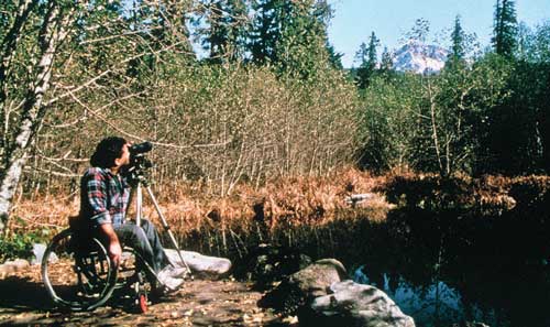
Figure 26—The perfect photo spot—a spectacular view and the right mix of resource protection, site development, and accessibility.
Deferred Maintenance
Maintenance work includes improving accessibility as well as compliance with building codes. Include the costs for any uncompleted work that is needed to bring a building into compliance with the provisions of ABA that were in force at the time of construction or major improvement to the building in the Natural Resource Manager database deferred maintenance costs.
If the transition plans to bring the structures into compliance with ABA provisions have not been completed, include the cost to complete them in the deferred maintenance figure because the plans were due for completion before the current fiscal year. The transition plan process (per 7 CFR 15e, section 150) is as follows:
-
Evaluate the facility.
-
Record improvements needed to meet accessibility standards.
-
Develop the transition plan, including:
-
Items to be improved.
-
Schedule with completion dates for improvements that will take more than 1 year to finish.
-
When the transition plan is completed and approved, include the costs to implement accessibility code improvements in the deferred maintenance figure. How and when the costs are included as deferred maintenance depends on the scheduling recorded in the transition plan. Costs for actions scheduled for the current year are immediately included in the deferred maintenance figure. Costs for actions that are past due as of the current fiscal year are also included in the deferred maintenance figure. Costs for actions scheduled for future years aren't added to the current year's deferred maintenance figure. These costs are added as deferred maintenance in the year they are scheduled for completion. As work is completed, it should be shown as an accomplishment in the Natural Resource Manager database for that fiscal year.
Construction and Maintenance Practices
Even the best universal design can be ruined, often unintentionally, by construction or maintenance practices that turn accessible design features into barriers. Construction engineering and inspection personnel must have a thorough understanding of the design intent and of accessibility issues or they must check with the designer before allowing any deviations from the design. Field changes, such as increasing the slope on a walkway to reduce the cost of asphalt paving or increasing the drop at an exterior door threshold to reduce issues with driving rain, can make the entire project inaccessible.
Construction Tip
Avoid unintended consequences.
Consider accessibility when construction is in progress. Any change order intended to solve one problem could create another. For example, standard speed humps can slow speeding traffic in a campground, but they can also become barriers if the main pedestrian access route through the campground is the roadway. Stagger speed humps to block only one lane at a time or limit them to the center of the road, leaving 32 inches (815 millimeters) of clear passage at each side. Both of these approaches will slow traffic without blocking access.
Maintenance and operations activities can help or hinder accessibility. Provide information on accessibility when training maintenance personnel. When employees understand how their work can affect accessibility, they can look for ways to improve accessibility. For example, trained maintenance and recreation personnel will know not to put a chair or garbage receptacle beside the door of an accessible restroom stall that would prevent the door from opening fully and thus render the stall inaccessible. They will know that picnic tables fastened to the floor of a picnic shelter to prevent theft must be spaced far enough apart so that everyone can use them. They will know not to allow gravel walkway material to erode away from the entrance to a campground restroom, creating an elevation change that makes the restroom inaccessible (figure 27).
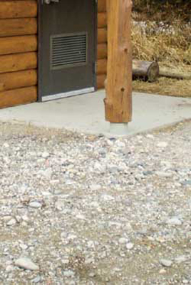
Figure 27—At this campground restroom entrance, the gravel walkway material has sunk or eroded, making the restroom inaccessible due to the difference in elevation between the walkway and the concrete.
Maintenance also can be an opportunity to improve accessibility. A series of small changes can make a big difference.
Design Tip
Use the VanHorn Roll to minimize maintenance.
Consider how time and normal weathering will affect accessibility when designing recreation areas. For instance, at the point where the concrete pad for a restroom meets the gravel outdoor recreation access route that connects it to the rest of the campground, gravel often erodes away from the concrete, leaving a drop in grade that doesn't meet accessibility requirements. Solve this problem by rolling the edge of the concrete down under the gravel surface of the outdoor recreation access route, as shown in figure 28. This is known as the "VanHorn Roll," named for the Unita-Wasatch-Cache National Forest recreation technician who invented the concept. A similar design can be used to keep the junction between asphalt and concrete surfaces accessible over time, as shown in figure 29.
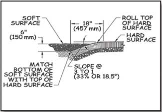
Figure 28—The VanHorn Roll is a design strategy to prolong the time a junction between concrete and gravel pedestrian surfaces meet the accessibility requirements without importing additional gravel to replace material that has eroded away.
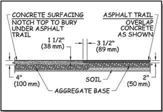
Figure 29—Differential settlement is less likely to occur between adjacent asphalt and concrete walking surfaces if the asphalt is overlaid onto a notch of the adjacent concrete surface.
Maintenance Tip
Improve accessibility through maintenance.
Improved accessibility doesn't always mean new construction or major renovation. Maintenance and routine service present many opportunities to improve accessibility.
An accessible surface is firm and stable. Use caution with the size and depth of gravel when maintaining unpaved surfaces. Generally, smaller gravel with some fine material can be compacted to a firmer surface than larger gravel or gravel that is all the same size. Depending on the surfacing material, mixing in some soil stabilizer may provide an accessible, natural-appearing surface.
Practical Approach
The surface is probably firm and stable if ruts are not left by:
-
Someone riding a bicycle with narrow tires
-
Someone pushing a 3-year-old in a folding stroller with small plastic wheels
On paved parking lots, designating the required accessible spaces is relatively easy when repainting the parking lot stripes, especially right after the lot has been seal-coated. Ensure that the appropriate wide, striped access aisles are provided next to each designated accessible parking space. The key to accessible parking is the striped zone next to it that ensures adequate space next to the vehicle to allow people to get into and out of their vehicle even if they use a wheelchair, crutches, or a walker.
Designating accessible parking spaces on gravel lots can be a problem because paint won't stay in place. If you designate accessible parking spaces only with a sign, designate end locations closest to the entrance. Ensure that accessible parking signs are 60 inches (1,524 millimeters) high and curb cuts are located appropriately—next to, not in the parking space or access aisle.
Building entries must be within ¼ inch (6.4 millimeters) of being flush with the grade of the outside access route and have a beveled doorsill that isn't more than ½ inch (13 millimeters) high. Sometimes it's fairly easy to add surfacing material, shim up the deck or porch boards, or use asphalt or concrete to bring the access route up to the building floor.
The surface at the base of water hydrants at recreation areas must be at least 72 inches (1,830 millimeters) by 48 inches (1,220 millimeters) and must be firm and stable. Consider building a grate and drain, or a paved surface, around hydrants if a soil or gravel surface can't be made firm and stable. If you don't have funding for a major site renovation, repair the area around a few hydrants at a time.
When operating controls need replacing, think about accessibility. To comply with accessibility guidelines, all controls must be operable by one hand without pinching, grasping, or twisting the wrist and with no more than 5 pounds (2.2 newtons) of pressure. When accessible parts are ordered, consider ordering extra parts for future replacements.
Practical Approach
If you can operate the control with one closed fist and with less than 5 pounds (2.2 newtons) of pressure, the control is accessible. Three ways to provide accessibility: push button, sensory-operated, and lever handle controls (figures 30, 31, and 32).
Figure 30—Push button control.
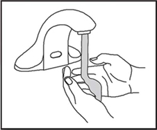
Figure 31—Sensory-operated control.

Figure 32—Lever handle control.
Designing Access Into the Outdoor Environment
This part of the guidebook explains how to incorporate the Forest Service Outdoor Recreation Accessibility Guidelines (FSORAG), the Forest Service Trail Accessibility Guidelines (FSTAG), and the applicable sections of the Americans with Disabilities Act/Architectural Barriers Act Accessibility Guidelines (ADA/ABAAG) into the outdoor recreation environment. The portion of ADA/ABAAG that applies to Federal agencies is also known as the Architectural Barriers Act Accessibility Standards (ABAAS) and is available at http://www.access-board.gov/guidelines-and-standards/buildings-and-sites/about-the-aba-standards/aba-standards.
Suppose you are assigned a project to reconstruct portions of a picnic area or to design a trail, but the work doesn't include any buildings. Based on previous information in this guidebook, you know to use FSORAG and FSTAG, rather than ABAAS, because FSORAG and FSTAG include accessibility provisions for all the features that will be part of the project. As you read through FSORAG and FSTAG, however, you may have questions about how to apply all the technical requirements, exceptions to the technical provisions, and conditions that allow for an exception. This part of the guidebook will help designers understand the rationale behind each of the provisions and how to apply the guidelines.
Terminology
Some phrases and words as used in the context of FSTAG and FSORAG may not be familiar. Examples include:
Conditions for an exception from a technical requirement are circumstances found in natural environments, construction practices, or certain laws that may make compliance with the requirements difficult.
Exceptions to the requirements are allowed under certain circumstances and are identified in paragraphs labeled exception in FSTAG and FSORAG.
Practicable means work that can be completed within the limits of the applicable conditions for exception and results in a useful improvement for all.
Provisions are the sections of accessibility guidelines and standards that explain what is required for specific situations and facilities (parking, picnic tables, trails, and so forth).
Scoping means figuring out when, how much, and where the guidelines apply.
Technical requirements state the specific numbers, conditions, and measurements that are required (percent that must comply, dimensions, reach ranges, grades, trail width, and so forth).
Specific phrases and words include:
Construction is building a new trail, recreation site, or facility where there was none before.
An alteration of a trail is a change in the purpose, intent, or function of the trail.
An alteration of a recreation site, building, or facility is a change to a portion of a recreation site, building, or facility that is addressed by the accessibility guidelines and that affects the usability of the site, building, or facility.
Maintenance means routine or periodic repair of existing trails, recreation sites, or facilities. Maintenance doesn't change the original purpose, intent, or function of a facility. Maintenance isn't covered by FSORAG or FSTAG. Maintenance includes but isn't limited to:
-
Repairing or replacing deteriorated, damaged, or vandalized trails, facilities, or components, such as repainting, removing graffiti, and repairing or replacing components of facilities with new components similar to the original ones. Components can be sections of bridges or boardwalks, signs, fencing and railings, siding, windows, and roofing.
-
Removing debris and vegetation, such as fallen trees or broken branches; clearing encroaching vegetation from trails, pathways, lawns, or landscaped areas; and removing rock slides.
-
Maintaining trail tread and access routes, such as filling ruts, reshaping a trail bed, replacing or reshaping surfacing material, repairing washouts, installing riprap to retain cut and fill slopes, constructing retaining walls or cribbing to support trail tread, and repairing concrete or asphalt paving.
-
Performing erosion control and drainage work, such as replacing or installing drainage dips or culverts and realigning sections of trail to reduce erosion or avoid boggy areas.
While FSORAG and FSTAG don't apply to maintenance, it is Forest Service policy to improve accessibility wherever the opportunity arises. Where practicable, resource managers are encouraged to improve accessibility through maintenance and repair activities as explained in MAINTENANCE TIP— Improve accessibility through maintenance.
The word "reconstruction" isn't used in Federal accessibility guidelines or FSORAG and FSTAG, even though it is frequently used in the recreation and trails communities. For the purposes of FSORAG and FSTAG, actions are categorized as construction, alteration, or maintenance.
The Purpose of FSORAG and FSTAG
FSORAG and FSTAG provide guidance for maximizing accessibility while recognizing and protecting natural settings, which can be challenging. Some basic assumptions:
-
Accessibility is to be considered up front, not as an afterthought.
-
The Forest Service policy of universal design is integrated into FSORAG and FSTAG.
-
All new construction and alterations for Forest Service outdoor recreation facilities and trails must meet the requirements of FSORAG and FSTAG.
-
FSORAG and FSTAG incorporate ABAAS sections that are applicable to outdoor developed areas.
-
Compliance with FSORAG and FSTAG does not mean that all recreation areas and trails will be accessible to all persons with disabilities; in some locations, the natural environment will prevent full compliance with some of the technical requirements.
FSORAG and FSTAG have sections explaining when, where, and how much of the recreation area or trail is included (scoping); what has to comply with the guidelines; definitions of terms; and technical requirements defining the physical characteristics of accessible features, such as width, height, slope, length, surface conditions, and so forth. The building blocks for accessible design are based mostly on wheelchair dimensions, clear space, maneuvering room, and reach ranges found in ABAAS because the dimensions, multiple moving surface contact points, and wheels of a wheelchair are the most difficult to accommodate. If someone in a wheelchair can use an area, most other people can too.
Each section of FSORAG is explained in practical terms, followed by a similar explanation of FSTAG.
Applying the Forest Service Outdoor Recreation Accessibility Guidelines
The first step in applying Forest Service Outdoor Recreation Accessibility Guidelines (FSORAG) is to know when and where compliance is required. Section 1.0 "Application" states that newly constructed and altered camping facilities, picnic areas, constructed features, beach access routes, and outdoor recreation access routes under Forest Service jurisdiction must comply with FSORAG. When we build something, we need to build it for everybody (figure 33). FSORAG, however, doesn't require the installation of any particular feature. For example, if we build a raised tent platform, it must comply with FSORAG requirements, but FSORAG doesn't require providing raised tent platforms.
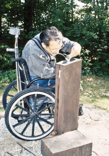
Figure 33— This water fountain works for most people.
Using the Conditions for an Exception in FSORAG
FSORAG is based on the realities of the outdoor environment. It recognizes that accessibility isn't possible everywhere because of the limitations imposed by natural terrain, existing vegetation, or other constraints. To ensure that the unique characteristics of the outdoor environment and recreation opportunity at a site aren't compromised or fundamentally altered, FSORAG section 1.1 requires achieving compliance with the technical accessibility requirements only to the extent practicable where certain circumstances (conditions for an exception) apply. These conditions apply only where an exception is specifically allowed in the technical requirement sections for a particular recreation feature.
Budget Tip
Extra cost is not an excuse.
If making a new or renovated recreation area accessible adds to the cost, the increase cannot be seen as an "undue financial burden."
When a Federal agency, such as the Forest Service, is funding a project, cost cannot be used as the reason for failing to make the project accessible, unless the cost of doing the work required by the accessibility guidelines would have a significant adverse impact on the agency's entire budget.
Conditions for an exception are not a blanket exemption from the technical requirements. Thoroughly explore all other design options that comply with the technical requirements and maintain the nature of the setting and experience before using deviations. When one or more of the following conditions for an exception exists in an outdoor recreation area, you may use a deviation from a specific technical requirement, but only where that condition exists. If that condition exists only on part of the feature or location, the technical requirement must be met for the rest of the feature or location. All the other technical requirements that are not affected by the condition for an exception still apply as well.
The following four conditions allow for deviations from specific technical requirements where exceptions are provided in the guidelines. Examples are provided to explain the intent of the conditions for each exception.
Condition for an Exception 1: Where compliance with the technical requirement is not practicable due to terrain
The phrase "is not practicable" in this condition for exception refers to something that isn't reasonable, rather than to something that is technically not possible. The intent of this condition is that the effort and resources required to comply shouldn't be disproportionately high relative to the level of access established.
Condition for an Exception 2: Where compliance with the technical requirement cannot be accomplished with the prevailing construction practices.
This condition for an exception may apply where construction methods that would be needed to comply with a technical requirement would require the use of equipment or methods other than those typically used in that setting. For instance, in an area where small equipment is normally used to minimize impact on a sensitive adjacent stream, blasting might be necessary to remove a rock outcrop to meet the technical requirement for width of an outdoor recreation access route. Because blasting typically would not be used in this situation, this condition for an exception would apply. If the work could be done using small equipment, the condition for an exception wouldn't apply.
Terminology Tip
What's practicable?
Using heavy construction equipment may make it possible to provide an outdoor recreation access route that is in compliance with the technical requirements for running slope in an area of steep terrain. However, extensive cuts or fills may be required, and that would cause drainage and erosion problems in highly susceptible soils. If compliance with the technical requirements would require building something that would be difficult, if not impossible, to construct or maintain properly, it is not practicable.
Design Tip
Determine where the conditions for an exception apply.
The following provides a good example of how designers may decide where a condition for an exception applies and where it might not. A renovation project at San Antonio Campground in the Santa Fe National Forest in the Southwestern Region includes a walk-in camping unit where a portion of the outdoor recreation access route is located on extremely steep ground, and there's no way to relocate the route to flatter land. The terrain makes it impossible to meet the technical requirement for running slope without severe cuts or fills.
Using the definitions in Forest Service Outdoor Recreation Accessibility Guidelines (FSORAG), the project is an alteration. Section 2.1 General Exception 2 of FSORAG allows a deviation from the slope requirement at existing recreation sites that are being altered, where a condition for an exception exists. A review of section 1.1 "Conditions for an Exception From the Technical Requirements" indicates that Condition for an Exception 1 applies to the section of the outdoor recreation access route that is on steep ground because compliance with the technical requirement for slope (grade) is not practicable due to terrain.
A deviation from the running slope requirement is permitted for the steep section of the outdoor recreation access route. However, all other technical requirements for the route, such as width, surfacing, and cross slope, must be met. Where the terrain is flatter and the cuts and fills aren't an issue, the technical provision for slope must be met. The exception to the slope requirement for the outdoor recreation access route to this particular walk-in campsite doesn't apply to other campsites at this campground. The outdoor recreation access route to each campsite must be examined individually to determine if a condition exists that would permit an exception to any requirement.
This condition for an exception isn't intended to exempt an area from the technical requirements simply because of a preferred construction practice. A contractor may prefer to use a large mechanical roller for efficiency rather than a smaller vibrating plate or impact-type compactor. A contractor's or designer's preference for the larger equipment doesn't by itself trigger the condition for an exception. A deviation from a specific technical requirement only is allowed if the equipment is essential to complete construction and if the work cannot be completed using the prevailing construction practices from similar locations.
Condition for an Exception 3: Where compliance with the technical requirement would fundamentally alter the function or purpose of the facility or the setting.
Public lands provide a wide variety of recreational settings, from highly developed campgrounds with plenty of opportunities for relaxing with family and friends to wilderness areas that provide opportunities to experience primitive and challenging conditions (figure 34). FSORAG recognizes the value of a wide array of recreation opportunities by allowing deviations from the technical requirements when compliance would unacceptably change the nature of recreation opportunities or conflict with the land and resource management plan for the area.
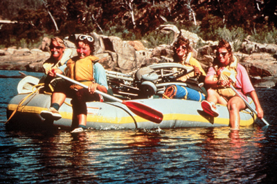
Figure 34—People like these rafters who recreate in primitive areas may be looking for challenge.
Design Tip
Look at the full range of issues.
Designers and managers need to examine the larger context and intent of the project to determine whether this condition for exception applies. Consider the full range of management and design issues during planning and continue throughout all stages of design development.
Consider existing and desired levels of development and site modification as identified in ROS classifications, visitor expectations, customer service, and so forth. Take into account how the site will be used. Will it be a jumping off point to a wilderness area where campers bring lightweight, compact equipment? Will it be a social gathering place where visitors bring a good portion of their worldly possessions and expect to have a place to set them up?
This condition for an exception would apply differently for a setting that has little or no human-influenced modifications than for a setting that has already been moderately or heavily modified, such as a highly developed recreation site.
Campers in a primitive setting experience the outdoor environment in a nearly natural state. These campers generally desire more challenge so they can rely on their outdoor survival skills. Manufactured building materials or engineered construction techniques that are used to comply with accessibility requirements could change the natural or undeveloped nature of the setting. You are not required to change the character of the setting and, therefore, change the nature of the recreation opportunity itself solely for the purpose of accessibility.
Condition for an Exception 4. Where compliance is precluded because the cultural, historic, or significant natural features are protected or are eligible for protection under Federal, State, or local law by:
-
Endangered Species Act (16 U.S.C. 1531 et seq.)
-
National Environmental Policy Act (42 U.S.C. 4321 et seq.)
-
National Historic Preservation Act (16 U.S.C. 470 et seq.)
-
Wilderness Act (16 U.S.C. 1131 et seq.)
-
Other Federal, State, or local laws that preserve threatened or endangered species, the environment, or archaeological, cultural, historical, or other significant natural features
Cultural features include archeological sites such as burial grounds and cemeteries, traditional cultural properties, tribal protected sites, and other properties considered sacred by an organized religion. Historic features are properties listed or eligible for listing on the National Register of Historic Places or other places of recognized historic value. Significant natural features are objects such as a large boulder or rocky outcrop, body of water, or unique vegetation that are regarded as distinctive or important locally, regionally, or nationally and, therefore, have been placed under legal protection (figure 35). This includes wilderness areas designated by Congress and areas protected under Federal or State laws, such as habitat for threatened or endangered species or designated wetlands.
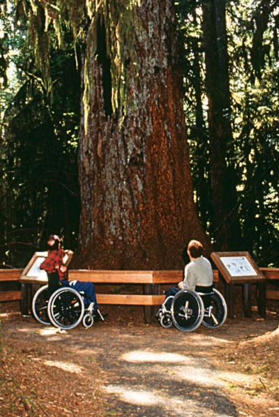
Figure 35—Properly developed recreation features don't harm unique vegetation; ancient trees are carefully protected.
Design Tip
Determine the extent of impact.
Only consider the additional impact of increasing the size, relocating the recreation feature, or implementing other changes to provide accessibility. For example, a proposed campsite may require that a number of trees of an uncommon species be removed. Removal would cause substantial harm to the tree grove. This condition for exception wouldn't apply if 15 trees must be removed to make way for a campsite that is not accessible and only three more trees must be removed to provide for one that is. The majority of the proposed damage to the grove is due to construction of the campsite, not due to compliance with accessibility requirements. In this case, an alternate location should be selected for the campsite.
Examples of situations in which this exception may apply include:
-
In wilderness areas designated by Congress, if work necessary to comply with a technical requirement can't be accomplished using handtools (use of mechanized equipment is prohibited by law)
-
Areas where imported materials, such as soil stabilizers, are prohibited to maintain the integrity of the natural ecosystem or historic resources
-
Designated wetlands or coastal areas where construction methods and materials are strictly limited
-
Tribal sacred sites where the undisturbed physical condition of the land is an important part of the sacred observance
-
Areas where water crossings are restricted to safeguard aquatic features or species protected under Federal or State laws
Documenting Exceptions
Recording and retaining documentation of determinations of the basis for exceptions for any outdoor recreation feature is a good practice. These records will become very valuable accounts of decisions and rationale when future changes are required or the public inquires about conditions.
Documentation is especially important for exceptions taken due to Condition 4. Federal laws and applicable State or local laws specified in Condition 4 prescribe certain activities or require certain analyses or procedures to be followed when planning to construct or alter facilities that may affect the cultural, historic, or natural features or species protected by that law. When work necessary to meet the technical requirements would directly or indirectly substantially harm the protected aspect, document the reason for the determination and then apply the exception. The documentation also may need to be included in the analysis or procedure records if required by specific laws.
Documentation of the basis for exceptions is required only when a condition for an exception prohibits full compliance with technical requirements on a portion of a trail or beach access route. An explanation of the condition that resulted in the determination that full compliance could not be achieved, the date the decision was made, and the name of the individuals who made the decision must be recorded and the documentation must be retained with the records for the construction or alteration project.
For trails or beach access routes only, if the entire trail or route must be exempted from the technical requirements because extreme or numerous conditions for exemptions make it impractical to provide a trail or route that meets the requirements, documentation must be sent to the U.S. Access Board. More information about this requirement is available in "Notifying the U.S. Access Board About Exemptions" and in "Documenting Exceptions and Notifying the U.S. Access Board About Exemptions" of this guidebook. Contact information for the U.S. Access Board is available at http://www.access-board.gov.
Getting From Here to There—Outdoor Recreation Access Routes
Providing accessibility in developed areas requires that people be able to get to features intended for public use. Outdoor recreation access routes are pedestrian routes that allow almost everybody to move around in a recreation area independently. Section 1.2 of FSORAG defines an outdoor recreation access route as "a continuous, unobstructed path designed for pedestrian use that connects constructed features in a campground, camping unit, picnic area, trailhead, or other recreation site where modifications are provided for visitor convenience and comfort." Figure 36 shows an outdoor recreation access route connecting a parking lot and scenic overlook. Section 2.0 of FSORAG contains the technical requirements for outdoor recreation access routes.
Outdoor recreation access routes are not required when camping facilities, picnic facilities, viewing areas, or outdoor constructed features are provided on trails. The routes connecting those facilities are to comply with the technical requirements for trails.
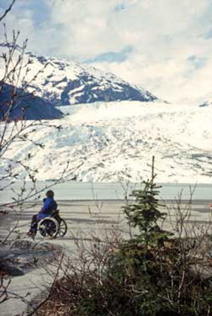
Figure 36—All people must be able to get from the parking area to the viewing area for the Mendenhall Glacier in Alaska; the same is true for other recreation sites in the National Forest System.
Outdoor recreation access routes ensure that visitors can move independently from their car or their camping or picnic spot to the other constructed features provided at a recreation area. When individual elements or constructed features are altered or replaced at existing recreation areas, Forest Service policy requires that they be accessible. However, if the ground under the element isn't changed as part of that renovation or replacement project, this work doesn't trigger the requirement for outdoor recreation access routes.
Design outdoor recreation access routes to meet technical requirements for running and cross slopes, resting intervals, surface, clear tread width, passing spaces, tread obstacles, protruding objects, and openings. If a condition for an exception prevents full compliance with a specific technical requirement on a portion of an outdoor recreation access route that is part of an alteration project, that portion of the outdoor recreation access route only has to comply with the specific technical requirements to the extent practicable. This deviation is not allowed for new construction; outdoor recreation access routes are required. When planning for a new outdoor recreation area or viewing area, the natural terrain and the general accessibility of the natural environment should be part of the site selection criteria.
Because individuals usually arrive at recreational vehicle (RV) dump stations by vehicle, there is an exception to the outdoor recreation access route connection requirement. A connecting outdoor recreation access route isn't required if an accessible vehicle pullup [sic] space is provided at the RV dump station.
The outdoor recreation access route may be provided within a roadway if the roadway is the only general circulation path for pedestrians at a recreation site. The outdoor recreation access route in the roadway isn't required to comply with outdoor recreation access route technical requirements for grade, resting, or passing intervals, but clear passage of 32 inches is required around or through speed restriction devices, gates, or other barriers.
Surfaces for Outdoor Recreation Access Routes
The surface of an outdoor recreation access route and the surface surrounding constructed features must be firm and stable. No exceptions are allowed. Slip resistance is not required because leaves and needles, dirt, ice, snow, and other surface debris and weather conditions are components of the natural environment and would be difficult, if not impossible, to avoid.
-
A firm surface resists deformation by indentations.
-
A stable surface is not permanently affected by expected weather conditions and can sustain normal wear and tear from the expected use(s) of the area between planned maintenance cycles.
Firm and stable surfaces prevent assistive devices from sinking into the surface. Surfaces that are not firm and stable make travel difficult for a person using crutches, a cane, a wheelchair, or other assistive device. In the accessibility guidelines, the standard assistive device is the wheelchair because its dimensions, multiple moving surface contact points and four wheels often are difficult to accommodate. If a person using a wheelchair can use an area, most other people also can use that area.
During the planning process, potential surface materials should be evaluated for noticeable distortion or compression during the season(s) of managed use and for stability under normal weather conditions and expected uses. If the surface won't remain firm and stable, another surface material should be used.
If the natural soils won't provide a firm and stable surface, soil stabilizer or artificial surfacing will be needed. The Forest Service technology and development report, "Soil Stabilizers on Universally Accessible Trails," contains information about the effectiveness of soil stabilizers. It is available at http://www.fs.fed.us/eng/pubs/pdf/00231202.pdf or http://www.fhwa.dot.gov/environment/fspubs/00231202/.
Design Tip
Use a rule of thumb to estimate firmness and stability.
What sort of surface is firm and stable? If the answer to both of the following questions is yes, the surface is probably firm and stable.
Could a person ride a narrow-tired bicycle across the surface easily without making imprints? (Bicycle tires are similar to the large rear wheels of a wheelchair.)
Could a folding stroller with small, narrow plastic wheels containing a 3-year-old be pushed easily across the surface without making imprints? (A stroller's wheels are similar to the front wheels of a wheelchair.)
While this method for determining firmness and stability isn't scientifically accurate, it has proven to be effective.
Design Tip
Provide appropriate walking surfaces for the setting.
A firm and stable surface does not always mean concrete and asphalt. The provision states that surface material should be appropriate to the setting and level of development. Some natural soils can be compacted so they are firm and stable. Other soils can be treated with stabilizers without drastically changing their appearance. Many surface materials that appear natural and that meet the firm and stable requirements also are available on the market. Investigate these options and use surface materials that are consistent with the site's level of development and that require as little maintenance as possible.
Construction Tip
Use better surface materials.
Generally, the following materials are more likely to provide firm and stable surfaces:
-
Crushed rock (rather than uncrushed gravel)
-
Rock with broken faces (rather than rounded rocks)
-
A rock mixture containing a full spectrum of sieve sizes, including fine material (rather than a single size)
-
Hard rock (rather than soft rock that breaks down easily)
-
Rock that passes through a ½-inch (13-millimeter) screen (rather than larger rocks)
-
Rock material that has been compacted into 3- to 4-inch (75- to 100-millimeter) -thick layers (rather than thicker layers)
-
Material that is moist (not soggy) before it is compacted (rather than material that is compacted when it is dry)
-
Material that is compacted with a vibrating plate compactor, roller, or by hand tamping (rather than material that is laid loose and compacted by use)
Slopes and Resting Intervals for Outdoor Recreation Access Routes
Running slope is the lengthwise slope of an outdoor recreation access route, parallel to the direction of travel. Outdoor recreation access route sections of any length may have a running slope ratio of up to 1:20, a 5-percent grade (figure 37). Steeper terrain may make this difficult to achieve. Many visitors can negotiate steeper slopes for short distances, so short segments of outdoor recreation access routes may be steeper, as shown in table 2, but the slope of an outdoor recreation access route may never exceed 1:10, a 10-percent grade. In this guidebook, the terms running slope and grade often are used interchangeably.
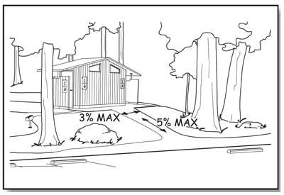
Figure 37—The basic slope requirements for outdoor recreation access routes and beach access routes.
Cross slopes—the side-to-side slope of an outdoor recreation access route—must not exceed 1:33 (3 percent), as shown by figure 37. However, if the surface of the outdoor recreation access route is paved or built with boards, the cross slope must not be steeper than 1:48 (2 percent).
Design Tip
The cross slope requirement depends on what material is used.
Those who use a mobility device know that as cross slope increases, travel becomes more difficult. This is because working against the sideways pull of the cross slope can double the effort needed to make forward progress. However, in an outdoor environment, the cross slope has to be steep enough that water won't accumulate on the travel surface. While slope and drainage can be precisely controlled on surfaces that are paved (asphalt, concrete, paving blocks, and so forth) or built with boards (wood planks, heavy timber, concrete, fiberglass, or other manufactured material), it's more difficult to ensure drainage on natural or gravel surfaces. When water accumulates on natural or gravel surfaces, they often become muddy and impassible. That's why the cross slope is allowed to be steeper on natural or gravel surfaces than on surfaces that are paved or built with boards.
Resting intervals are relatively level areas that provide an opportunity for people to catch their breath before continuing along the outdoor recreation access route. These intervals are required between each outdoor recreation access route segment any time the running slope ratio exceeds 1:20 (5 percent) as shown on table 2. A resting interval must be at least 60 inches (1,525 millimeters) long and at least as wide as the widest segment of the outdoor recreation access route leading into it, if the resting interval is within the outdoor recreation access route. If the resting interval is beside the outdoor recreation access route, it has to be at least 60 inches (1,525 millimeters) long and at least 36 inches (915 millimeters) wide. Depending on the design and location, the intersection of two outdoor recreation access routes may act as a resting interval.
| Runnign [sic] Slopes on ORARs | Maximum Length of Segment Between Resting Intervals | |
|---|---|---|
| Steeper than | But not Steeper than | |
| 1:20 (5 percent) | 1:12 (8.33 percent) | 50 feet (15 meters) |
| 1:12 (8.33 percent) | 1:10 (10 percent) | 30 feet (9 meters) |
Construction Tip
Slope and grade terminology.
Slopes are often described as a ratio of vertical distance to horizontal distance, or rise to run. For instance, a slope ratio of 1:20 means that for every 1 foot of vertical rise, there are 20 feet of horizontal distance; for every meter of vertical rise, there are 20 meters of horizontal distance (figure 38). When the slope ratio is stated as a percent, it is referred to as the grade. A 1:20 slope stated as a percent would be a 5 percent grade.
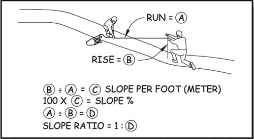
Figure 38—Determining the slope ratio.
The slopes of a resting interval may not exceed a ratio of 1:33 (3 percent) in any direction (figure 39). However, if the surface is paved or is built with boards, the slope can't be steeper than 1:48 (2 percent) in any direction.
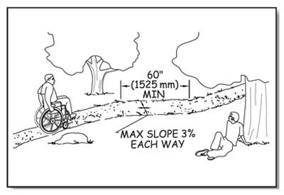
Figure 39—The basic resting interval requirements for outdoor recreation access routes.
Grade requirements for an outdoor recreation access route may be more difficult to meet when altering an existing site than during new construction. Accessibility was seldom considered when older recreation sites were designed. Many campgrounds and picnic areas were located in spectacularly scenic settings, but on steep terrain. Complying with the grade requirement in these areas may be difficult without a fundamental change to the recreation environment. A deviation is allowed for alteration projects where a condition for an exception exists.
In alterations only, if a condition for an exception prevents full compliance with a specific technical requirement on a portion of an outdoor recreation access route at camping and picnic facilities and at trailheads, that portion of the outdoor recreation access route is required to comply with the specific technical requirement only to the extent practicable.
This deviation from the technical requirement is not allowed to be used for new construction at camping and picnic facilities or at trailheads. When planning for a new outdoor recreation area, the natural terrain and the general accessibility of the natural environment should be part of the site selection criteria because compliance with outdoor recreation access route requirements is required for new construction.
Clear Tread Width and Passing Spaces for Outdoor Recreation Access Routes
Clear tread width means the width of the traveled surface on the ground and also above the ground between obstacles (figure 40). The minimum clear tread width of an outdoor recreation access route is 36 inches (915 millimeters), which is wide enough to allow unobstructed passage by a wheelchair. When a condition for an exception exists, such as where an outdoor recreation access route must be routed between two large boulders that can't be removed, then the clear tread width may be reduced to not less than 32 inches (815 millimeters) or the maximum width that can be achieved.
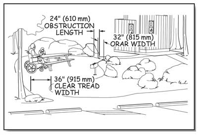
Figure 40—The clear tread width is the unobstructed width of the traveling surface.
All outdoor recreation access routes in a recreation site don't necessarily have to be the same width. Consider the number of people who will use the route at the same time and how they will want to use it—single file or walking and talking side by side—and design accordingly. For example, a 60-inch (1,525-millimeter) -wide main route may be designed to connect a group of campsites to important constructed features, such as a rustic outdoor amphitheater, toilet buildings, or water hydrants. Secondary routes, such as a spur from the main route to a quiet, intimate path along a stream, may be only 36 inches (915 millimeters) wide.
Two people using wheelchairs need a 60-inch (1,525-millimeter) -clear tread width to pass comfortably and safely on an outdoor recreation access route. However, this width isn't always appropriate or required. Where the clear tread width of a route is less than 60 inches (1,525 millimeters), passing spaces are required at least every 200 feet (61 meters). Passing spaces must be at least 60 inches (1,525 millimeters) wide (including the route width) by 60 inches (1,525 millimeters) long (figure 41).
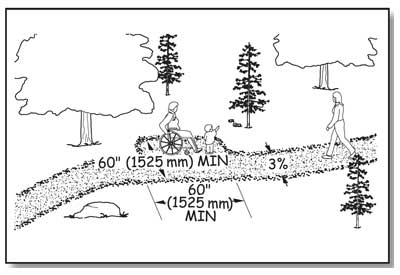
Figure 41—Minimum required dimensions for a passing space for an outdoor recreation access route or a beach access route.
Another option allows a T-intersection of two outdoor recreation access routes or other walking surfaces to be a passing space (figure 42) provided that the arms and stem of the T-shaped space extend at least 48 inches (1,220 millimeters) beyond the intersection. Either configuration would provide enough room for a person to move to the side and let an oncoming person pass along the route. The cross slope of a passing space must not exceed 1:33 (3 percent). Where the surface is paved or is built with boards, the slope must not be steeper than 1:48 (2 percent) in any direction.
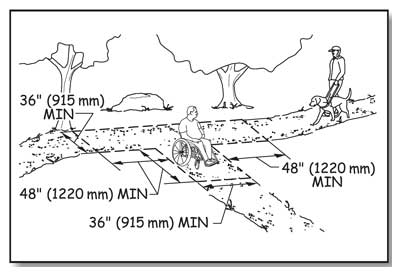
Figure 42—A T-intersection may be used as a passing space on an outdoor recreation access route or a beach access route if it has dimensions as shown, or larger.
Design Tip
Access route width may vary.
The 36-inch (915-millimeter) minimum clear tread width is just that—a minimum. To determine how wide the outdoor recreation access routes in a project should be, look at the level of development of the site and how the site will be used. In a more highly developed area, a 48- or 60-inch (1,220- or 1,525-millimeter) -wide route may be appropriate, while a 36-inch (915-millimeter) -wide tread may be a better fit in a less developed site.
Tread Obstacles on Outdoor Recreation Access Routes
A tread obstacle is anything that interrupts the evenness of the tread surface. On outdoor recreation access routes, an obstacle may occur where a tree root or rock protrudes above the surface or where two different surfaces abut, such as when a concrete path joins an asphalt path. If they are pronounced, tread obstacles can pose a serious tripping hazard. Where tread obstacles exist along an outdoor recreation access route, they must not be more than 1 inch (25 millimeters) high. Where the surface is paved or is built with boards, obstacles must not be more than ½ inch (13 millimeters) high.
Design Tip
Avoid the use of stairs on outdoor recreation access routes.
In new construction, stairs aren't allowed on outdoor recreation access routes except at viewing areas where there is a condition for an exception. For new recreation sites, select locations that will not require the use of stairs.
Avoid the use of outdoor stairs wherever possible. Sometimes, an alteration project at an existing recreation site includes an area where stairs can't be avoided. When stairs are unavoidable, they should generally meet the requirements for stairs in Architectural Barriers Act Accessibility Standards. Although these requirements are not mandatory for stairs that aren't part of a means of egress for a building, compliance will ensure the stairs are safe and comfortable to use.
The accessibility guidelines for outdoor recreation areas do not require handrails for stairs. Consider the safety of the people using the stairs and the setting when deciding whether handrails are appropriate. What is the expected amount of use? How can the appearance of overdevelopment be avoided while providing for safe use of the stairs? When deciding whether handrails are necessary on outdoor stairs, also consider how many should be provided. For example, a few steps at an individual campsite may not need a handrail. Where a handrail would be helpful, one handrail in the center may accommodate low-volume, two-way traffic. Treads that are just wide enough for one-way traffic could have a handrail on one side. Two handrails may be needed if stairs are provided in hightraffic areas.
Openings in Outdoor Recreation Access Route Surfaces
Openings are gaps in the surface of an outdoor recreation access route. Gaps include spaces between the planks on a boardwalk or in a drainage grate. Openings that are big enough to allow wheels, cane or crutch tips, or shoe heels to drop through or get stuck are hazards that shouldn't occur in pedestrian routes (figure 43). Openings up to a half of an inch (13 millimeters) wide are permitted. Place elongated openings that are more than a quarter of an inch wide with the long dimension perpendicular or diagonal to the primary direction of travel (figure 44).
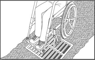
Figure 43—Big openings in outdoor recreation access route surfaces create problems.
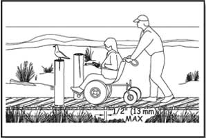
Figure 44—Elongated openings must be perpendicular to the direction of travel.
Protruding Objects and Outdoor Recreation Access Routes
Objects that extend into the travel way of an outdoor recreation access route from the side or from overhead can be hazardous to people who are paying more attention to their companions than the travel route, as well as to people who are blind or have low vision. Protruding objects are defined as constructed features (such as signs) that extend into the clear width area of an outdoor recreation access route, resting interval, or passing space and that are between 27 inches (685 millimeters) and 80 inches (2,030 millimeters) above the travel surface. Do not allow constructed features to extend into the clear width area more than 4 inches (100 millimeters, figure 45).
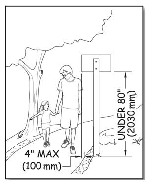
Figure 45—Constructed features can't extend into the clear width area more than 4 inches if they are between 27 and 80 inches (685 to 2,030 millimeters) above the walking surface.
Accessibility guidelines do not consider natural elements (such as tree branches and rock formations) to be protruding objects. Provide and maintain clearance from natural elements around outdoor recreation access routes in accordance with your unit's standards, keeping in mind overhanging hazards to people who are blind or have low vision, or are not focused on the route ahead.
Design Tip
Edge protection may be used for outdoor recreation access routes.
Edge protection is a raised curb, wall, railing, or other structure that defines the edge of a travel surface and may help keep people on the travel surface. Edge protection is not required for accessibility on outdoor recreation access routes, and it is not usually desirable in outdoor environments because it isn't as easy to see or detect objects near the ground. However, edge protection may be desirable for safety or other reasons. Edge protection curbs (figure 46) in an outdoor environment are required to be at least 3 inches (75 millimeters) high.
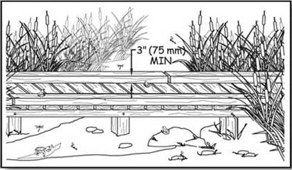
Figure 46—Edge protection is optional on an outdoor recreation access route, but if present, edge protection must be at least 3 inches high.
Gates and Barriers
If gates or barriers are constructed to control access to outdoor recreation access routes, beach access routes, or trails, include openings wide enough to allow hiker passage (figures 47 and 48) that complies with ODAAG, section 1017.3 Clear Tread Width. That section requires 36 inches (915 millimeters) of clear width. However there may be areas where Condition for an Exception 3 applies (for instance, where providing a 36-inch-wide opening would allow the entrance of motorized vehicles that are not permitted behind the barrier). In such circumstances, 32 inches (815 millimeters) clearance, the same as is required for an interior door, will provide pedestrian access to the recreation opportunity without permitting motorized access behind the gate or barrier. Be sure to document all exceptions. If there is a gate, measure the clear opening width with the gate open 90 degrees. As required in ABAAS, section 307.2, do not allow projections into the clear opening width between the trail surface and 27 inches (685 millimeters) above the trail surface. Projections of more than 4 inches (100 millimeters) aren't allowed between 27 inches (665 millimeters) and 80 inches (2,030 millimeters) above the trail surface. ABAAS, section 404.2.3 also contains allowances for projections of closers and stops that aren't likely to apply to trail barriers or gates. Examples of blockage by and passage around barriers are shown in figures 21 and 22. The clear opening width is the key. The travel surface must meet the same requirements as the adjacent outdoor recreation access route, beach access route, or trail.
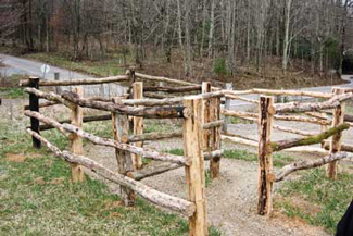
Figure 47—The winding configuration of this rustic chicane where the Appalachian Trail crosses Tennessee Highway 91 and the Osborne farm allows pedestrians to pass through the fence to use the trail but keeps motorized users out and horses inside the farm fence.
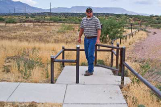
Figure 48—A steel kissing gate on the Prescott National Forest prevents passage by motor vehicles. The design balances the principles of the Built Environment Image Guide with the needs for access control. Sturdy, vandal-resistant materials were needed to discourage determined off-road vehicle users.
Gate hardware must comply with ABAAS, section 404.2.7. This section refers to the requirement in ABAAS, section 309, that controls and operating mechanisms have to be operable with one hand without tight grasping, pinching, or wrist twisting, using a force no greater than 5 pounds (2.2 newtons), as explained in "Reach Ranges and Operability Requirements." It also requires that operable parts of latches must be located between 34 inches (865 millimeters) and 48 inches (1,220 millimeters) above the trail surface. The operating hardware for sliding gates must be exposed and usable from both sides. In alterations, a projection of five-eighths of an inch (16 millimeters) into the clear width is allowed for the gate latch stop.
Designs for several accessible gates (figure 49) are available in the Forest Service publication "Accessible Gates for Trails and Roads" at http://fsweb.mtdc.wo.fs.fed.us/php/library_card.php?p_num=0623%202340. The publication includes drawings for gates that can be used to close roads and trails to motor vehicle access while still providing providing 36-inch-wide (915-millimeters-wide) passage for pedestrians and devices that meet the definition of a wheelchair (see figures 6 through 11), as well as other gate designs that allow pedestrian and equestrian passage while prohibiting motor vehicle access.
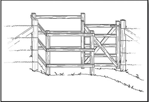
Figure 49—This timber kissing gate is one of the designs available in the Forest Service publication Accessible Gates for Trails and Roads.
Providing Comforts and Conveniences—Constructed Features
Constructed features are the site furnishings and other elements provided in picnic areas, campgrounds, and other recreation sites. The requirements for constructed features are addressed in sections 3, 4, and 5 of FSORAG. Section 3 "Recreation Sites" addresses the layout of recreation sites, including vehicle parking, camping and picnic units, viewing areas, and use of the international symbol of accessibility and other signs. Section 4 "Constructed Features in Recreation Sites" addresses individual site amenities, including picnic tables; fire rings; fire grills; fireplaces; wood stoves; tent pads and platforms; trash, recycling, and other essential containers; telescopes and periscopes; utilities; water hydrants; utility sinks; and outdoor rinsing showers. Section 5 "Buildings in Recreation Sites" addresses requirements for buildings that are not included in ABAAS, such as camp shelters and pit toilets. These subjects will be addressed in the same order in this document.
Construct, purchase, and install only elements and constructed features that comply with the accessibility guidelines, as directed by the Forest Service policy of universal design. For example, even if steep terrain or other conditions in an alteration project at a recreation site preclude complying with the slope requirements for the outdoor recreation access route to a picnic table or camping unit, all the components and furnishings still must comply with the relevant sections of FSORAG. Individuals can select the location where they want to picnic or camp without being limited by the location of accessible features of the picnic or camping unit. This requirement includes all picnic tables, pedestal grills, and other features in a picnic area or campground if they are purchased or constructed by or on behalf of the Forest Service. The few exceptions to this general rule are explained in the section for each feature.
Construction Tip
Determine if features are really accessible
Manufacturers don't necessarily understand accessibility requirements. Some manufacturers advertise their products as "accessible" or "Americans with Disabilities Act compliant," even though they aren't. Accessible means a product is in compliance with the applicable accessibility requirements. Compare the dimensions of the product to the applicable Architectural Barriers Act Accessibility Standards or Forest Service Outdoor Recreation Accessibility Guidelines requirements to make sure that a product, such as a picnic table or fire ring, is truly accessible. Ask the manufacturer for the shop drawings or for the location of a retailer or campground near you where you can examine the product.
When individual elements and constructed features wear out or are damaged and must be replaced, the Forest Service requires that the renovated or replaced elements or features be accessible. However, if the ground under the element isn't changed, this work doesn't trigger the surface and slope requirements for clear floor and ground space.
FSORAG doesn't require that any particular constructed feature be provided in a picnic area or campground. If there were no plans to provide outdoor rinsing showers, utility sinks, or utility hookups at a campground, FSORAG wouldn't require them to be installed. However, if a feature is provided, FSORAG must be met.
Construction Tip
Fix it while you’re there.
Bringing the surface and slope of the ground under an individually replaced element or constructed feature up to new construction standards isn't required. However, you may be able to save time and money over the long haul by shaping and smoothing the surface before putting in the new table. If you integrate logical improvements every time you replace a component, accessibility may be achieved without a large construction project.
Design Tip
How to design features that are not addressed in Forest Service Outdoor Recreation Accessibility Guidelines.
If you want to provide a constructed feature that isn't addressed in Forest Service Outdoor Recreation Accessibility Guidelines (FSORAG), design it using the basic building blocks of accessible design, including clear space dimension requirements for a wheelchair and reach ranges found in Architectural Barriers Act Accessibility Standards (ABAAS).
For example, lantern hooks are sometimes provided in campgrounds, but FSORAG doesn't address them. Using the information in ABAAS and the principles of universal design, design the hooks to be usable by the greatest number of campers. The hooks should be placed within the reach of a person who is seated, as well as a person who is standing.
Use a hinged device to adjust the height of the hook or install two hooks at different heights. Consider safety when designing a post with multiple or adjustable hooks. Ensure the lantern hook has appropriate clear space to allow a person in a wheelchair to approach it from the front or the side, and place the hook where it will not create an obstacle to people moving around the campsite. The clear space for the lantern hook shouldn’t overlap the outdoor recreation access route.
Clear floor or ground space is required around the usable sides of each constructed feature, but the size of the clear space varies with the feature. The differences are based on how each feature is used and whether users need to approach just one side of the feature or all sides of it. For instance, users may only need to get to the front of a pedestal grill that doesn't rotate or to the front and sides of a water hydrant, but they need to get to all sides of a picnic table or fire ring.
When several constructed features are grouped together, such as in a camp living area or picnic unit, their clear spaces may overlap. For example, the 48-inch (1,220-millimeter) clear space around a picnic table may overlap the 48-inch (1,220-millimeter) clear space around a pedestal grill. Do not allow the clear space at a constructed feature within a camp living area or picnic unit to overlap the outdoor recreation access route that connects the camp living area or picnic unit to the rest of the recreation site. Also, do not allow the clear space to overlap any outdoor recreation access route that is adjacent to the camp living area or picnic unit but leads to a common use feature, such as a water hydrant.
Ensure that individual constructed features, such as water hydrants, are connected by outdoor recreation access routes in developed recreation sites, by beach access routes on beaches, and by trails when features are located along a trail. More information about connectivity requirements is provided in the parts of the guidebook on recreation site layout and constructed features.
Within individual camp living areas or picnic units, the slope, surface, and size of the required clear spaces of individual constructed features usually provide the required connectivity and eliminate the need for separate outdoor recreation access routes. The overlapping or adjacent clear spaces function as the outdoor recreation access routes, beach access routes, or trails. Sometimes features are spread apart to limit the amount of change to the natural setting, and the clear spaces for individual features are not adjacent or overlapping. In these cases, provide the appropriate outdoor recreation access routes, beach access routes, or trails to connect the features.
Reach Ranges and Operability Requirements
In this guidebook, you will see the provision "Controls and operating mechanisms must comply with the requirements for reach ranges and operability specified in ABAAS, sections 308 and 309" whenever a site feature has buttons, knobs, handles, or other controls or operating devices. One of the basic principles of universal design and accessibility is to provide controls that most people can reach and use.
Design Tip
Understand forward reach and side reach terminology.
When the phrases "forward reach" and "side reach" are used in the context of accessibility, they don't refer to the object a person is trying to reach. They refer to the position of the person doing the reaching. A forward reach means that the person is facing the object and reaching forward toward it (figure 50). A side reach means that the person's side is closest to the object, and the person is reaching either to their right or left towards the object (figure 51). People using wheelchairs can't reach as far forward over their laps as they can reach to the side. They also need correctly sized spaces to position their wheelchairs to be able to reach objects from the front and from the side. That is why there are different height and clear floor space requirements for forward and side reaches.
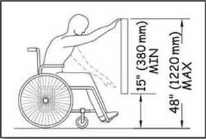
Figure 50—The requirements for unobstructed forward reach.
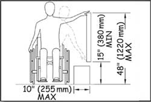
Figure 51—The requirements for unobstructed side reach.
ABAAS, section 309 requires that controls and operating mechanisms be operable with one hand without tight grasping, pinching, or wrist twisting, using a force no greater than 5 pounds (2.2 newtons). To test a control, try operating it by applying light force with one closed fist, without bending your wrist.
Section 308 of ABAAS identifies the following reach requirements:
-
Unobstructed Reaches—When a forward or side reach is unobstructed, the object to be reached must be no higher than 48 inches (1,220 millimeters) and no lower than 15 inches (380 millimeters) above the floor or ground (figures 50 and 51). For side reaches only, an object that is below the object to be reached and isn’t more than 10 inches (255 millimeters) wide doesn't count as an obstruction.
-
Obstructed Forward Reach—When an object must be reached over an obstruction, the clear floor space must extend beneath the obstruction for at least as far as the reach depth over the obstruction. The object to be reached is not allowed to be under the obstruction. If the obstruction is 20 inches (510 millimeters) deep or less, the object to be reached must be between the top of the obstruction and 48 inches (1,220 millimeters) above the floor or ground (figure 52). If the obstruction is more than 20 inches (510 millimeters) deep, the object to be reached must be between the top of the obstruction and 44 inches (1,120 millimeters) above the ground or floor (figure 53). The obstruction must not be more than 25 inches (635 millimeters) deep.
-
Obstructed Side Reach—For side reaches, obstructions must not be more than 34 inches (865 millimeters) high or 24 inches (610 millimeters) deep. The object to be reached is not allowed to be under the obstruction. If the reach depth is 10 inches (255 millimeters) or less, the object to be reached must be 48 inches (1,220 millimeters) or less above the ground or floor (figure 54). If the reach depth is between 10 and 24 inches (255 and 610 millimeters), the object to be reached must not be more than 46 inches (1,170 millimeters) above the floor or ground (figure 55).
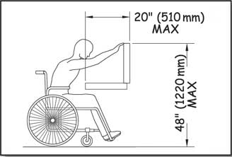
Figure 52—The requirements for obstructed high forward reach, narrower obstacles.
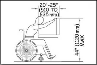
Figure 53—The requirements for obstructed high forward reach, wider obstacles.
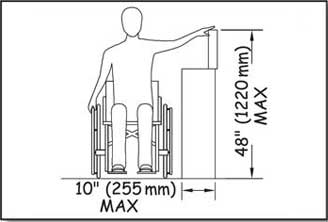
Figure 54—The requirements for obstructed high side reach, narrower obstacles.
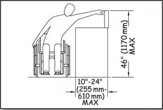
Figure 55—The requirements for obstructed high side reach, wider obstacles.
Grab Bars
Grab bars are usually provided in buildings to provide stability and allow people to use their arms to assist in movement over short distances. The most common location for grab bars is in restrooms. Grab bars must comply with the reach range requirements of ABAAS, section 308, as explained in "Reach Ranges and Operability Requirements." They must also comply with the size, strength, finish, and position requirements in ABAAS, section 609 as follows:
-
Grab bars with circular cross sections must have a diameter no less than 1¼ inches (32 millimeters) and no more than 2 inches (51 millimeters). Grab bars with noncircular cross sections must not be more than 2 inches (51 millimeters) across and must be 4 to 4.8 inches (100 to 120 millimeters) around. Figure 56 shows how this is measured.
-
Grab bars and any wall or other surfaces adjacent to grab bars must have rounded edges and are not allowed to have sharp or abrasive surfaces.
-
Grab bars must be installed so they don't rotate within their fittings.
-
Grab bars have to be strong enough to support 250 pounds (1,112 newtons) of pressure at any point on the grab bar, fastener, mounting device, and supporting structure.
-
The space between the wall and the grab bar must be 1½ inches (38 millimeters). There must also be a space of 1½ inches (38 millimeters) between the grab bar and any projecting objects below or at the ends of the grab bar. There must be at least 12 inches (305 millimeters) between the grab bar and any projecting objects above it, except multiple grab bars only have to be 1½ inches (38 millimeters) apart.
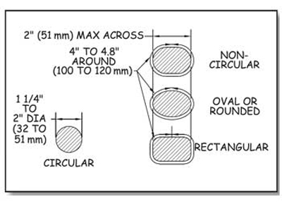
Figure 56—The requirements for the diameter and circumference of grab bars.
Recreation Site Layout
Designing an attractive and functional recreation site is an art as well as a science. Accessibility is, of course, one of the many design parameters for any recreation site.
Vehicle Parking
Within recreation areas, vehicle parking is normally either concentrated into parking lots for more than two vehicles at group areas or distributed into parking spurs designed to hold one or two vehicles or trailers at an individual picnic or camping unit. Vehicle parking lots and other parking spaces that aren't associated with an individual camping or picnic unit must comply with the same requirements as vehicle parking lots for buildings. These requirements can be found in ABAAS, sections 208 and 502. However, slip resistance is not required for parking in recreation areas because leaves and needles, dirt, ice, snow, and other surface debris and weather conditions are components of the natural environment that would be difficult, if not impossible, to avoid.
Parking spurs for one or two vehicles, recreational vehicles (RVs), or trailers at individual picnic or camping units or at parking spaces for RV dump stations must comply with the requirements in section 3.1 of FSORAG. Parking spurs have two components; driveways and parking areas. The driveway is primarily a vehicle travel way that functions as an extension of the recreation site roadway. It provides vehicular access and a transition between the recreation site road and a vehicle parking area. The vehicle parking area is the section of the parking spur where vehicles (cars, vans, recreational vehicles, trucks, trailers, and so forth) are parked. These definitions are important because the scoping and technical requirements vary based on the specific part of the parking spur being addressed. Figure 57 shows the parts of a parking spur.
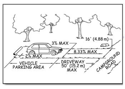
Figure 57—The components of a campground parking spur.
Because people use the parking spur to get to and from their vehicle and to get around the recreation site, ensure that the surface of the entire parking spur is firm and stable as explained in "Surfaces for Outdoor Recreation Access Routes" of this guidebook.
Ensure each vehicle parking area that is adjacent to a camp living area is at least 16 feet (4.88 meters) wide. The 16-foot (4.88-meter) width is the same as the standard width for an accessible parking stall for vans.
Sometimes, a single parking area for a double camping unit accommodates two vehicles side-by-side. In these parking areas, the space between the two vehicles can be used to access both vehicles, so you can reduce the total width of the two non-RV parking areas from 32 feet (9.76 meters) to 24 feet (7.32 meters).
Design Tip
Determine parking requirements for walk-in camping units.
For walk-in camping units, the required parking area width depends on whether the parking area is part of the camping unit or in a group parking lot. If the walk-in unit has its own parking spur, then it falls under Forest Service Outdoor Recreation Accessibility Guidelines parking spur requirements and the parking area should be 16 feet (4.88 meters) wide (as required by the vehicle parking area provision), or less if a condition for an exception applies. If the parking space is part of a group parking area such as a 10-car parking lot that is provided for eight walk-in units, the whole parking lot must meet the requirements of Architectural Barriers Act Accessibility Standards, sections F208 and 502. In such a 10-car parking lot, 9 parking spaces would be standard width and 1 would be 16 feet (4.88 meters) wide to comply with the van-accessible specifications of an 8-foot (2.44-meter) -wide parking space and an adjoining 8-foot ( 2.44-meter) -wide access aisle.
Provide enough width for full size accessible RVs and trailers in campgrounds that are designed to accommodate them (figure 58). A 16-foot (4.88-meter) -wide parking area will accommodate cars, vans, and the majority of RVs and trailers. However, a vehicle parking area that is 20 feet (6 meters) wide is required to accommodate lifts, ramps, and other assistive equipment that allow RV owners to enter, exit, and move around all sides of larger accessible RVs and trailers. The dimensions are based on an 8-foot (2.44-meter) -wide vehicle, an 8-foot (2.44-meter) -wide space on the passenger side for operation of the lift or ramp with room to maneuver and a 4-foot (1.22-meter) -wide clear space along the driver's side.
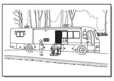
Figure 58— An accessible recreational vehicle with a wheelchair lift.
When parking areas for large accessible RVs accommodate two vehicles side-by-side in a parking area serving a double camping unit, the space between the two vehicles can be used to access both vehicles. Less width is required to provide the same access, so you can reduce the total width of the two RV parking areas from 40 feet (12 meters) to 36 feet (11 meters).
To maximize accessibility while protecting the natural environment, only a limited number of vehicle parking areas in campgrounds with RV camping units must be 20 feet (6 meters) wide. The minimum number of required 20-foot (6-meter) -wide vehicle parking areas is based on the total number of camping units provided in the RV campground (table 3).
Table 3—The number of recreational vehicle (RV) parking areas required to be accessible.
| Number of Camping Units | Minimum Number of 20-foot (6-meter) -Wide Vehicle Parking Areas Required in Campgrounds With Units Designed for Large RVs and Trailers |
|---|---|
| 1 | 1 |
| 2 to 25 | 2 |
| 26 to 50 | 3 |
| 51 to 75 | 4 |
| 76 to 100 | 5 |
| 101 to 150 | 7 |
| 151 to 200 | 8 |
| 201 and over | 8 plus 2 percent of the number more than 200 |
Basing the number of required 20-foot (6-meter) -wide RV parking areas on the number of RV camping units is similar to the approach used by ABAAS for accessible hotel rooms. The minimum required number of accessible rooms is proportional to the total number of rooms in the hotel. Similarly, the minimum number of accessible RV parking areas is proportional to the total number of RV camping units in the campground.
For example, in a 50-unit campground that accommodates large RVs and trailers, a minimum of three vehicle parking areas must be 20 feet (6 meters) wide. The vehicle parking areas for the remaining 47 camping units must be at least 16 feet (4.88 meters) wide, with the exceptions previously noted.
When designing a new campground, remember that table 3 shows minimum requirements. Larger RVs and trailers with bump-out sections are increasingly common. Areas where many recreationists use larger RVs and trailers may require providing more camping units with a 20-foot (6-meter) -wide vehicle parking area.
Some national forests have found the 20-foot (6-meter) -wide RV parking area to be an appropriate design standard for use throughout their RV campgrounds.
If there are one or more conditions for an exception that prevent constructing a full-width parking area (at least 16 feet (4.88 meters) wide or 20 feet (6 meters) wide as required by table 3), you can reduce the width to 13 feet (4 meters), the width of an accessible parking space for cars. Because new recreation site locations should be chosen carefully to ensure accessibility requirements can be met, this exception should hardly ever be taken. Even when conditions for exception are numerous and extreme, at least 20 percent of parking areas must be full width. When only one or two non-RV parking areas are provided in a recreation area, no exception is permitted. When three to 10 non-RV parking areas are provided, at least two of the vehicle parking areas must be full width.
There are separate slope requirements for vehicle parking areas and driveways because of the different functions they perform. Do not allow the slope of the vehicle parking area to exceed 1:48 (2 percent) in any direction. However, when the surface is not paved or built with boards, slopes up to 1:33 (3 percent) in any direction are allowed when needed for proper drainage.
Design Tip
Determine how long the parking area should be.
Forest Service Outdoor Recreation Accessibility Guidelines has requirements for parking area or spur width, but not length. Length of parking area spurs depends on the terrain and the type of vehicles that are expected to use the parking area. Ordinary parking lots are normally designed with 20-foot (6-meter) -long parking spaces to accommodate passenger vehicles, so parking areas should be at least 20 feet (6 meters) long. A large trailer with a towing vehicle could be up to 60 feet (18 meters) long and a bus-style recreational vehicle (RV) could be up to 45 feet (14 meters) long.
Some campgrounds include parking spurs of various lengths. This limits campsite choices for campers with larger trailers or RVs, but also minimizes hardened surfaces and ground disturbance, especially on difficult terrain. Provide information online and at the campground regarding the length of parking areas. Campers with larger trailers and RVs will appreciate it.
The running slope of a parking spur driveway may be up to 1:12 (8.33 percent) for 50 feet (15 meters). An exception for areas of steeper terrain permits the running slope to be up to 1:10 (10 percent) for 30 feet (9 meters). In alterations of existing campgrounds only, a second exception permits the running slope to be up to 1:10 (10 percent) for distances up to 50 feet (15 meters) if the first exception can't be met because of a condition for an exception. This second exception does not apply to new construction.
The cross slope of a parking spur driveway must not exceed 1:33 (3 percent). However, the cross slope of driveways may be as steep as 1:20 (5 percent) if needed for proper drainage or to provide a transition from the campground road to the vehicle parking area. For example, if a back-in parking spur is adjacent to an interior campground road that has a running slope steeper than 1:20 (5 percent), the driveway may need a steeper cross slope to make the transition from the running slope of the road to the relatively level vehicle parking area (figure 59).
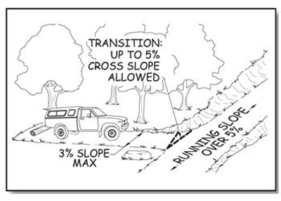
Figure 59—The transition from a parking spur driveway to a campground road.
Design Tip
Allow for pedestrians in the driveway.
Because people move around the vehicle parking areas and along the driveways, parking spurs also have to be able to function as outdoor recreation access routes.
Keep the running and cross slopes of driveways, even in alterations, as gentle as possible so that vehicles and people can easily and safely navigate into and out of the camping unit, erosion is minimized, and road design and construction standards are met.
Camping Units
A camping unit is a part of a campground that is used by an individual or group for camping separate from other parties using the recreation site. A camping unit commonly includes the camp living area, a parking spur, and a space to pitch a tent (figure 60). FSORAG doesn't require a specific number or type of camping units or constructed features, but all camping units and the site furnishings and constructed features in them must meet the applicable FSORAG requirements.
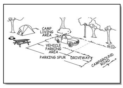
Figure 60—The components of a camping unit.
The camp living area is the space where tables, fire rings, and grills are located. This area is often adjacent to the parking spur. The minimum size of a camp living area is determined by the type and number of constructed features provided and the required clear space around each feature. Ensure the surface of camp living is firm and stable, and that the surface material used is appropriate to the setting and level of development. Do not allow the slope of the ground surface in camp living areas to exceed 1:48 (2 percent) in any direction, except when the surface is unpaved or is not built with boards. In those cases, the slope may be up to 1:33 (3 percent) for necessary drainage.
To meet outdoor recreation access route requirements, a route must connect all the features within each camping unit. Usually, the slope, surface, and size requirements for the overlapping or adjacent clear spaces of the constructed features within camp living areas eliminate the need for separate outdoor recreation access routes within the camp living area. When features are spread apart to limit the amount of change to the natural setting, provide outdoor recreation access routes to connect the features.
There must also be an outdoor recreation access route connecting each camping unit with the common use features that are provided at the campground, such as toilets, showers, water hydrants, garbage receptacles, parking spaces, and beach access. Ensure this outdoor recreation access route does not overlap the clear spaces of the camp living area so that people using the constructed features in the camp living area will not obstruct travel along the outdoor recreation access route.
There are some exceptions to the requirement that outdoor recreation access routes must connect everything.
-
When work is done to improve an existing camping or picnic facility or a trailhead and a condition for an exception prohibits full compliance with a specific technical requirement on part of an outdoor recreation access route, that part of the outdoor recreation access route only has to meet the technical requirement to the extent practicable.
-
When something is changed within an existing camping facility, but the circulation path isn't altered, the path doesn't have to be brought up to outdoor recreation access route standards.
-
As stated in "Getting From Here to There—Outdoor Recreation Access Routes" of this guidebook, if an accessible vehicle pull-up space is provided at the RV dump station, an outdoor recreation access route is not required to connect the station to the camping units.
-
In campgrounds where the roadway is the primary route from the campsites to the restrooms and so forth, a separate outdoor recreation access route to the same facilities is not required. That roadway is not required to meet the specifications for an outdoor recreation access route. However, there must be a minimum of 32 inches of clear passage through or around any constructed obstacles in the roadway, such as speed bumps.
Even when they're not required, the Forest Service commitment to universal design dictates that outdoor recreation access routes connect as many features as is practicable, given the specific natural constraints of the site, the level of development, and other considerations.
When walk-in camping is provided in a campground, ensure an outdoor recreation access route connects the camp living area to the parking spur or parking lot. If the terrain is steep (or there's another condition for an exception) and the work is an alteration to an existing site, compliance with the slope requirements for the outdoor recreation access route to those walk-in units isn't required.
When a camping unit is located near a trail (rather than in a campground accessed by vehicles), the connection between that unit and the trail and the connections between the constructed features within that camping unit must comply with FSTAG requirements for trails, not the outdoor recreation access route requirements.
Picnic Units
A picnic unit is a part of a picnic area that contains one or more constructed features used for picnics by an individual or a group. Each picnic unit may be used separately from other parties using the recreation site. All site furnishings and constructed features that are provided in a picnic unit must meet the applicable FSORAG requirements. The minimum size of a picnic unit is determined by the required clear space around each feature and the type and number of provided constructed features
Ensure all pedestrian routes that are provided in a picnic area meet outdoor recreation access route standards. Use an outdoor recreation access route to connect all features within each picnic unit. Usually, the slope, surface, and size requirements for the overlapping or adjacent clear spaces of the unit's constructed features within a picnic unit eliminate the need for separate outdoor recreation access routes within the unit. When features are spread apart to limit the amount of change to the natural setting, provide an outdoor recreation access route to connect the features.
If a picnic area only has one or two picnic units, connect all units with an outdoor recreation access route to the area's common use features, such as toilets, showers, water hydrants, garbage receptacles, parking spaces, and beach access routes. If a recreation site has more than two picnic units, use an outdoor recreation access route to connect at least 20 percent of the units (but never less than two) to the common use features at the site. For example, in a picnic area with 20 units, all site furnishings (tables, grills, etc.) must be accessible, and a minimum of four picnic units must be connected by an outdoor recreation access route to the area's other common use features.
When designing picnic areas, remember locating 20 percent of the units on an outdoor recreation access route is only a minimum requirement. Connect as many units with an outdoor recreation access route to the major features of the site as practicable, given the specific natural site constraints, the level of site development, and other considerations.
FSORAG recognizes that the natural terrain often presents a real obstacle in the outdoor recreation environment. At existing sites that are being renovated, you may not be able to provide an outdoor recreation access route for all picnic units without affecting the fundamental nature of the picnic area and the recreation opportunity. When an existing picnic area is altered or reconstructed and a condition for an exception prohibits full compliance with a specific technical requirement on part of an outdoor recreation access route, that part of the outdoor recreation access route only has to meet the technical requirement to the extent practicable. When something is changed within an existing picnic facility, but the circulation path isn't altered, the path doesn't have to be brought up to outdoor recreation access route standards. Even though it's not required, these changes almost always provide you the perfect opportunity to bring the paths up to outdoor recreation access route standards and follow the Forest Service policy of universal design.
Viewing Areas
Overlooks and viewing areas are designed and constructed to provide scenic vistas and unobstructed views of points of interest, such as a mountain range, a valley, a waterfall, or a unique geologic formation (figure 61). Because overlooks and viewing areas are destination points, they must be accessible so all visitors can enjoy the viewing opportunities. Ensure that each viewing area at an overlook and all the site furnishings, constructed features, and buildings in it, comply with applicable FSORAG and ABAAS provisions. However, when work is done to improve an existing viewing area or overlook and a condition for an exception prohibits full compliance with a specific technical requirement for a clear ground space, unobstructed view, turning space, surface, or slope, you only have to meet the requirement to the extent practicable.
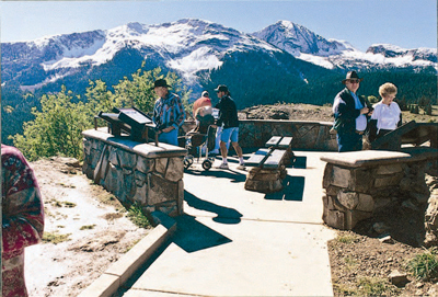
Figure 61—The overlook on the San Juan Skyway, a scenic byway in Colorado, allows all visitors to enjoy the view.
Viewing areas in recreation settings must be located along an outdoor recreation access route that connects to the other major features at the site, including the parking area. There are some exceptions to the requirement to connect everything with outdoor recreation access routes. Sometimes vistas can only be viewed from an area with difficult terrain. If a condition for an exception prohibits full compliance with a specific technical requirement for a portion of an outdoor recreation access route at a viewing area, you only must ensure that portion of the outdoor recreation access route complies with the technical requirement to the extent practicable. When something is changed within an existing overlook or viewing area, but the circulation path isn't altered, you don't have to bring the path up to outdoor recreation access route standards. Even though it's not required, renovations almost always provide you with the perfect opportunity to bring the paths up to outdoor recreation access route standards so that everyone can get to the viewing area or overlook.
Ensure each viewing area that is required to be accessible has a clear ground or floor space that is at least 36 inches (915 millimeters) by 48 inches (1,220 millimeters) and is positioned for either a forward or parallel approach to the viewing location. Each accessible viewing area must also have at least one turning space that is 60 inches (1,525 millimeters) minimum in diameter (figure 62) or is a T-shaped space with a minimum 60- by 36-inch (1,525- by 915-millimeter) arm and a minimum 36-inch (915-millimeter) -wide by 24-inch (610-millimeter) -long base (figure 63). The clear ground space and turning space may overlap. The turning space requirement is the same as ABAAS section 304.3. These spaces allow someone using a wheelchair or other assistive device to approach and move about the viewing area.
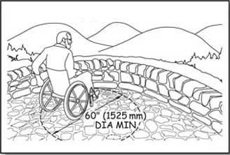
Figure 62—One way to meet the requirements for turning space at a viewing area.
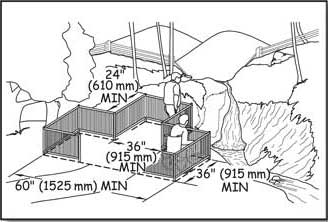
Figure 63—The requirements for a T-shaped turning space at a viewing area.
If there are several viewing areas, provide at least one accessible, unrestricted viewing opportunity for each distinct point of interest. An unrestricted viewing opportunity means a clear field of vision toward the vista or point of interest that extends at least from 32 to 51 inches (815 to 1,295 millimeters) above the entire side of the clear floor or ground space of the viewing area.
Ensure the slope of clear floor or ground spaces and turning spaces does not exceed 1:48 (2 percent) in any direction. When the surface isn't paved or built with boards, allow grades up to 1:33 (3 percent) in any direction if needed for proper drainage. Ensure the surface is firm and stable and of a material that is appropriate to the setting and level of development. Restrict openings in the surface of clear ground spaces and turning spaces to small enough that a ½-inch (13-millimeter) -diameter sphere can't get through them. Place elongated openings more than a quarter of an inch wide with the long dimension perpendicular to the primary direction of travel.
Viewing areas often are adjacent to hazardous dropoffs. When there is a dropoff of more than 30 inches (760 millimeters), provide a guardrail or barrier that complies with the height and opening requirements of the International Building Code, sections 1012.2 and 1012.3.
Barriers such as walls, guardrails, or signs installed for safety reasons could restrict views. However, neither accessibility nor safety measures should be ignored. Designers need to consider different ways of providing for safety without blocking the view. For example, narrow vertical rails, seethrough [sic] panels, or screened openings could be installed, or the designer may be able to build the overlook with a series of tiers or terraces (figure 64). The placement of interpretive signs may also help create a barrier to keep people back from the edge of the overlook without blocking the view (figure 65).
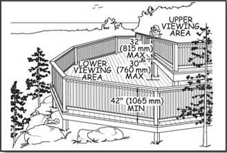
Figure 64—This overlook design has two levels so the railing can be lower at the upper viewing area.
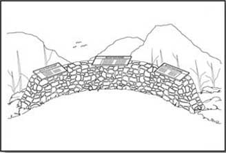
Figure 65—Signs placed to create a barrier at an overlook.
Design Tip
Design guardrails for safety and views.
Providing safety while maximizing viewing opportunities is a challenge for those designing a guardrail or structure adjacent to a dropoff. It's possible to design two viewing levels (see figure 64), where the lower level would be less than 30 inches (760 millimeters) below the upper level.
With this design, a tall guardrail isn't required for the upper level. At the upper level, where the visitors generally approach the viewpoint, a low railing or wall can permit good visibility. The lower viewing level would have a tall guardrail meeting the International Building Code requirements. This lower level provides the "catch" area for the primary level.
If the area or structure doesn't lend itself to a two-level approach, try a see-through 42-inch (1,065-millimeter) -high guardrail (figure 66). Place the vertical rails so that a 4-inch (100-millimeter) sphere can't pass through them. Visibility through this type of guardrail is excellent. The eye level of most adults seated in a wheelchair is above 42 inches (1,065 millimeters), and children sitting on the deck can enjoy the view through the rails.
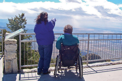
Figure 66—This railing on an overlook at Sandia Crest on the Cibola National Forest is safe, meets code requirements, and provides a great view for people of all heights.
The importance of vertical rather than horizontal rails can't be overemphasized. When children see horizontal rails, they regard them as an inviting ladder that encourages them to climb. A horizontal rail can't protect them from a fall (figure 67).

Figure 67—Caution: Railings with horizontal rails make an inviting ladder for small children.
Use of the International Symbol of Accessibility and Other Signs
Signs provide key information concerning the accessibility of programs and facilities. People often think of the International Symbol of Accessibility (ISA) (figure 68) as an all-purpose sign to be used any time an accessible feature is available, which is not necessarily true.

Figure 68—International symbol of accessibility.
In accordance with ABAAS, section 216, ISA must be posted at only six places:
-
At accessible parking spaces in parking lots with five or more designated parking spaces.
-
Sign van accessible parking spaces in these lots as such.
-
Sign RV accessible parking spaces in these lots as such.
-
Do not post ISA at parking spurs provided at camping units or other individual accessible features.
-
-
At accessible loading zones.
-
At accessible restrooms and bathing facilities.
-
At the main entrance to a building, with an arrow directing people to the closest accessible entrance, if the main entrance is not accessible.
-
On the door to an accessible area of refuge inside multistory buildings.
-
At an accessible means of egress out of a building.
Except for the requirement to post the VAN ACCESSIBLE plaque at van accessible spaces, no other descriptive words are required to be used with ISA. If words are used, use "accessible." Do not use "handicapped."
Where all constructed features and areas comply with the accessibility provisions, you may post ISA, but it is not required. Do not individually sign accessible sites with ISA because this can stigmatize and draw unwanted attention to the individuals using those sites.
When only some constructed features and areas comply with the accessibility provisions, people need to know whether they will be able to use a particular campsite or picnic area. This can be accomplished using several methods, depending on the type of campground or picnic area.
The Federal agency recreation reservation system (http://www.recreation.gov) contains accessibility information about campsites and picnic areas that are registered in the system, including which individual sites are accessible. When using this system to reserve a site, people are automatically notified if they are about to reserve an accessible site. ISA also can be used to identify individual accessible sites on the recreation site map on the Web site describing the recreation site. These are both good ways to provide accessibility information to recreationists with Internet access.
If some—but not all—campsites or picnic areas are accessible and recreationists choose their site when they arrive at the recreation area, provide accessibility information to recreationists as they enter the area. ISA can be used to identify the individual units that comply with the accessibility guidelines on the recreation site map at the entrance kiosk, fee station, bulletin board, or registration area. Post the following type of statement on the registration information sign: "Units 2, 4, 6, and 10 are accessible. If no one in your group needs an accessible site, please fill these units last." Forests that use this type of statement on the registration sign report that visitors generally have complied.
If some—but not all—campsites or picnic areas are accessible and the sites are assigned by a person onsite who can provide information about each unit, you don't have to post accessibility information. The accessible units should be assigned as requested by individuals. The accessible sites that are not assigned to persons with disabilities should be filled last, keeping them available in case they are needed. Do not ask people who request or reserve an accessible site to state or show any type of verification of their disability.
Their vehicles are also not required to display a license plate or placard indicating a disability. This site reservation and assignment process complies with the court-ordered process followed by hotels concerning their accessible rooms.
There is no legal requirement on federally managed lands for ISA signs to be blue and white, even at parking spaces. If ISA is used, post it on a vertical sign in accordance with ABAAS, section 703.7, in high-contrast colors with a nonglare finish. A cream or pale yellow ISA on a brown background complies with this requirement and blends into an outdoor setting.
If you want the local law enforcement agency to be able to issue tickets for illegal parking at accessible parking spaces in parking lots, display ISA in blue and white to comply with the Manual of Uniform Traffic Control Devices (MUTCD), section 2B.39. Although their use is optional, the only approved colors for pavement markings designating accessible parking spaces are blue and white (MUTCD, section 3B.18).
If a sign or kiosk has materials to be handled, such as maps, brochures, fee envelopes, and so forth, design the sign or kiosk so that the materials are displayed within the standard accessible reach ranges in accordance with ABAAS, section 308, as explained in "Reach Ranges and Operability Requirements" of this guidebook. Provide clear floor or ground spaces of 30 by 48 inches (760 by 1,220 millimeters) to allow a forward or parallel approach.
Post the appropriate international symbols where various modes of alternative formats, communication, or adaptive equipment are available. Large print, open captioning, sign language interpreters, and so forth are each represented by a specific symbol (figures 69 through 77).

Figure 69—International symbol for information.

Figure 75—International symbol to indicate sign language interpretation is available.

Figure 72—International symbol for video or film with closed captions.

Figure 70—International symbol for teletypewriter (also referred to as "TTY").

Figure 76—International symbol to indicate large print (18 point) material is available.

Figure 73—International symbol to indicate audio description is available.

Figure 71—International symbol for a telephone with volume control.

Figure 77—International symbol to indicate materials are available in Braille.

Figure 74—International symbol to indicate an assistive listening system is available.
If you have questions about applying any of the above information, please contact your region's recreation accessibility coordinator. Current contact information is available at http://www.fs.fed.us/eng/toolbox/acc/documents/coord.htm#leaders.
Constructed Features in Recreation Sites
All new constructed features at Forest Service recreation sites must meet accessibility requirements. Depending on the type of site, ensure all or a portion of the features are connected to the other features within the recreation site by an outdoor recreation access route as explained in "Recreation Site Layout" of this guidebook.
If constructed features are replaced, but the ground under the feature isn't changed, the surface and slope of the ground under the feature doesn't have to be brought into conformance with accessibility requirements for clear floor and ground space. Because of the Forest Service policy of universal design and the cost savings inherent in accomplishing all anticipated improvement work at an area at once, doing whatever is feasible to improve accessibility while you're working in the area is recommended.
Picnic Tables
All new picnic table installations must comply with requirements for accessible seating spaces, table clearance, slope, and surface. This is true whether the table is in a campground, picnic area, or other recreation site. "Recreation Site Layout" explains how the tables in each of these types of recreation sites must be connected to the other major constructed features at the recreation area. If the picnic tables are provided on trails, ensure the routes connecting them to any other major constructed features in the area comply with the technical requirements for trails.
The number of wheelchair seating spaces that must be provided at each table is based on the length of the picnic table (figure 78). Always ensure at least one wheelchair seating space. For larger tables, one wheelchair seating space is required for each 24 linear feet (7.32 meters) of usable space around the perimeter of the table. Practically speaking, tables up to 9 feet (2.74 meters) long usually require one space. Tables between 10 feet (3.05 meters) and 20 feet (6 meters) long usually require two wheelchair spaces, and so on for longer tables, such as four spaces for tables that are 40 feet (12 meters) long.
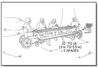
Figure 78—At least two spaces must be accessible at a 10- to 18-foot (3- to 5.5-meter) -long picnic table.
Knee space for wheelchair seating must be at least 30 inches (760 millimeters) wide, 19 inches (485 millimeters) deep, and 27 inches (685 millimeters) high, as measured from the ground or floor to the bottom of the tabletop. Toe clearance of at least 9 inches (230 millimeters) above the ground or floor must extend at least an additional 5 inches (25 millimeters) beyond the required knee clearance. Figure 79 illustrates the required knee and toe space. Toe clearance is required to ensure that someone in a wheelchair is able to sit close to the tabletop, regardless of the design of the picnic table. If the table is constructed with one solid leg on each end, as opposed to an A-shaped frame or two individual legs on each end of the table that would allow the wheelchair to fit in between, the toes of a person in a wheelchair would hit the table leg at the end of the 19-inch (485-millimeter) knee space. Without additional toe clearance, a person in a wheelchair wouldn't be able to get close enough to the tabletop to use it comfortably.
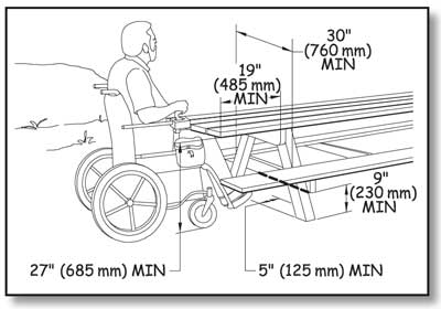
Figure 79—The requirements for knee and toe space at a picnic table.
Construction Tip
Ensure picnic tables are accessible.
Manufacturers often claim their tables are accessible even though they don't meet accessibility requirements. Check the dimensions to verify whether a table is accessible.
Provide clear floor or ground space that is 30 inches by 48 inches (760 millimeters by 1,220 millimeters) at each wheelchair seating space, positioned to accommodate a forward approach to the table (figure 80). No exceptions to the wheelchair seating space requirements are permitted.
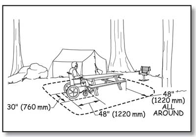
Figure 80—The requirements for clear space at a picnic table.
In addition to the clear floor or ground space for each wheelchair seating space, provide a 48-inch (1,220-millimeter) clear floor or ground space around the usable portions of the table (see figure 82). Measure table clearance from the table seat out. You may reduce the table clear space to 36 inches (915 millimeters) if there is a condition for an exception.
The slope of the required clear floor or ground space for wheelchair seating spaces and for table clearance is not allowed to exceed 1:48 (2 percent) in any direction. Slopes not steeper than 1:33 (3 percent) are permitted, however, where necessary for drainage on surfaces that are unpaved or not built with boards. The surface of the clear floor or ground space must be firm and stable. The type of surfacing used should be appropriate to the setting and level of development.
Design Tip
Design for appropriate picnic table height.
There is no height requirement in Forest Service Outdoor Recreation Accessibility Guidelines for the table top surface of a picnic table or the top of the table benches. Architectural Barriers Act Accessibility Standards require that tops of dining surfaces be 28 inches (710 millimeters) to 34 inches (865 millimeters) above the finished floor or ground. Table tops may be constructed of a number of different materials, and some of them, such as heavy timbers, may be quite thick. The knee space for wheelchair seating at a picnic table must be at least 27 inches (685 millimeters) high. User comfort is important. Generally, benches that are around 18 inches (457 millimeters) above the ground with table top surfaces that are about 32 inches (813 millimeters) above the ground are reasonably comfortable for most people, accommodate common picnic table construction materials, and meet accessibility requirements.
If a condition for exception in an alteration project at an existing site prohibits full compliance with a specific requirement for clear floor or ground space (surface, slope, size, or location), the clear floor or ground space only has to comply with requirements to the extent practicable.
Design Tip
Use different clear spaces for forward and parallel approaches.
A forward approach means that the person is facing the object (see figure 50). A parallel approach means that the person is beside the object (see figure 51). People need different-sized spaces to position their wheelchairs in front of an object and beside an object. That is why there are different clear floor or ground space requirements for forward and parallel approaches.
Design Tip
Use the picnic tables recreationists prefer.
The most popular accessible picnic tables look like ordinary 8-foot-long tables, but the legs are located slightly closer to the center of the table so that they meet wheelchair seating requirements at both ends. The benches are the same length as the tabletop (figure 81). The benches that extend the same length as the table top provide a seat at each corner beyond the table leg. The four corner seats are prized by individuals who may have difficulty stepping over the bench to be seated. At the corner seats, a person simply slides in. Figures 82, 83, and 84 show some examples of accessible tables that can be built by contractors or Forest Service crews. The tables can be locally constructed using the plans available at http://www.fs.fed.us/recreation/programs/accessibility and also available to Forest Service employees at http://fsweb.wo.fs.fed.us/eng/facilities/accrec/tables/. Use the links to view the tables or to save AutoCAD drawings of the tables.
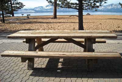
Figure 81—This picnic table at Nevada Beach day use area in the Lake Tahoe Basin Management Unit is a popular design that allows people who use wheelchairs to use either end without the appearance of "separate" space. A Forest Service shield is routed into the cross piece on each end, adding to the design appeal.
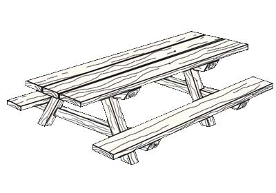
Figure 82—An accessible wood picnic table.
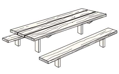
Figure 83—An accessible steel leg picnic table.
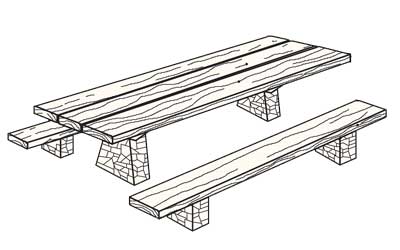
Figure 84—An accessible stone leg picnic table.
Fire Rings, Grills, Fireplaces, and Wood Stoves
An outdoor recreation access route must connect fire rings, grills, fireplaces or wood stoves that are provided in recreation sites to the other major constructed features at the recreation site. If the fire rings, grills, fireplaces, or wood stoves are provided in an area accessed by rail (rather than by vehicle), the routes connecting them to any other major constructed features provided in the area must comply with the technical requirements for trails.
Provide a clear floor or ground space around all usable sides of a fire ring, grill, fireplace, or wood stove so that someone isn't forced to get too close to the heat or fire and risk getting burned. The clear space must extend at least 48 inches (1,220 millimeters) out from the feature and be at least 48 inches (1,220 millimeters) wide. In many cases, a 48-inch (1,220-millimeter) -wide ring of clear space must be provided all around (figure 85), because all sides are usable. For instance, if a pedestal grill can rotate 360 degrees and all positions along that rotation are usable, the 48-inch (1,220-millimeter) clear space must completely surround the grill. If the grill doesn't rotate, clear space is only required on the sides from which access is needed to use the grill. Most fire rings are also usable on all sides. This space may be reduced to 36 inches (915 millimeters) minimum where a condition for exception exists.
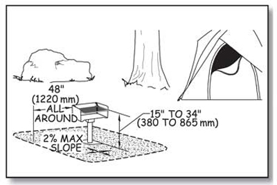
Figure 85—The requirements for height, clear space, and reach range for a pedestal grill.
The slope of the clear floor or ground space must not exceed 1:48 (2 percent) in any direction. When the surface is unpaved or not built with boards, slopes 1:33 (3 percent) and less are allowed where necessary for drainage. The surface of the clear floor or ground space must be firm and stable, and the surface material used should be appropriate to the setting and level of development. However, if a condition for exception in an alteration project at an existing site prohibits full compliance with a specific requirement for clear floor or ground space (surface, slope, size, or location), the clear floor or ground space only has to comply with requirements to the extent practicable.
Ensure the fire-building surface within a fire ring is a minimum of 9 inches (230 millimeters) above the floor or ground surface. Figures 86 and 87 show fire-building surfaces above the ground. This matches the low side reach range in ABAAS.

Figure 86—This manufactured fire ring has an internal grate that elevates the fire-building surface 9 inches (230 millimeters) above the ground. The mesh ring above the fire-building grate allows enjoyment of the fire and allows air supply to aid combustion. The cooking grate swings to the side for access to the fire. Photo credit: Jamestown Advanced Products Corporation, Jamestown, NY.
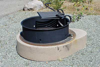
Figure 87—The Prescott National Forest uses standard manufactured steel fire rings on fire-hardened concrete bases so that the fire-building surface meets accessibility requirements for height above the ground.
Some "fire rings" are not constructed features and don't meet the criteria for applying these requirements. For example, in the Boundary Waters Canoe Area Wilderness, people sometimes assemble rings of rocks at popular campsites and build campfires in them. To reduce the risk of campfires becoming uncontrolled fires, they may sometimes be allowed to remain rather than being immediately dismantled by the agency. The accessibility requirements for fire rings do not apply to these temporary, user-built "fire rings."
Controls and operating mechanisms for fire rings, grills (figure 88), fireplaces, and wood stoves must meet the requirements for reach ranges and operability specified in ABAAS, sections 308 and 309 that are explained in "Reach Ranges and Operability Requirements" of this guidebook. Several fire ring and grill manufacturers make models that comply with the reach range and operability requirements.
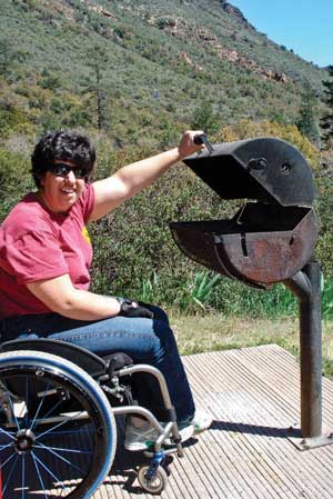
Figure 88—This pedestal grill at a campground on the Coconino National Forest works well for just about everybody.
Accessible models of some other wood-burning devices are not yet readily available. For these devices, compliance with the accessibility requirements for operating controls isn't required until models that meet the requirements are readily available from more than one source.
Ensure that each cooking surface, grill, and pedestal grill meets the requirements for cooking surface height, clear floor or ground space, slope, and surface. The height requirements are based on the height for countertops and the minimum low forward reach range in ABAAS. Ensure the height of the cooking surface is 15 inches (380 millimeters) to 34 inches (865 millimeters) above the floor or ground surface (see figure 85). Practically speaking, the lower range of the required height is associated with fire rings, not pedestal grills. Adjustable pedestal grills may be adjustable beyond the required range, but must include adjustments within the specified range. The adjustments don't have to include the entire range of acceptable heights for cooking surfaces.
Construction Tip
Install pedestal grills at appropriate heights.
Most pedestal grills have adjustable cooking heights. Make sure that the pedestal is installed at a height that allows adjustments to include cooking surfaces 34 inches above the ground or lower, but still provide a reasonable clearance between the cooking surface and the fire-building surface.
Some outdoor fireplaces and custom-built fire rings have a raised edge or wall around the fire-building area, perhaps built out of bricks or mortared stone. In addition to meeting the requirement for a fire-building surface that is at least 9 inches (230 millimeters) above the ground or floor, make sure the width of the raised edge or wall does not exceed 10 inches (255 millimeters). Figures 89, 90, and 91 illustrate the requirements for fire rings and outdoor fireplaces.
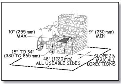
Figure 89—The height, clear space, and reach range requirements for an outdoor fireplace.
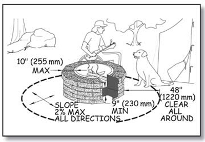
Figure 90—The height and reach requirements for custom-built fire rings.
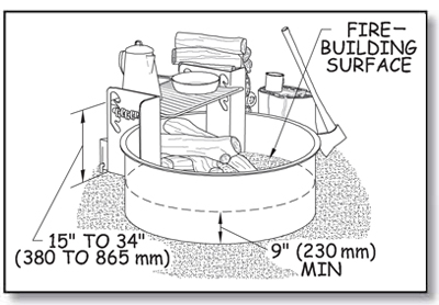
Figure 91—The height and reach requirements for manufactured steel fire rings.
Tent Pads and Tent Platforms
Ensure that tent pads and tent platforms at single camping units in a recreation area meet the following requirements and are connected to the area's other major constructed features by an outdoor recreation access route. At least 20 percent (but not less than two) of the tent pads or tent platforms in group camping units that contain more than one tent pad or tent platform must meet the following requirements and be connected to the area's other major constructed features by an outdoor recreation access route.
Provide a minimum 48-inch (1,220-millimeter) clear floor or ground space on all sides of tents on tent pads and platforms that are required to be accessible. Where there is a condition for an exception, the clear floor or ground space only has to meet the size requirement to the extent practicable.
There is no minimum tent pad size because the types of tents commonly used in recreation sites vary widely in different parts of the country and even in different parts of a single district. For example, at a campground near a wilderness access point, small tents may be used. Large family tents may be common at a more developed campground with numerous constructed features.
Local campground managers are the best source of information about the size of tents commonly used in an area. Adding the 48-inch (1,220-millimeter) or 36-inch (915-millimeter) clear space to the size of a typical tent will determine the minimum size of tent pads and platforms for that campground. Designers may want to provide a range of tent pad or platform sizes to accommodate a variety of tents.
Do not allow the slope of an accessible tent pad or platform to exceed 1:48 (2 percent) in any direction, except when the surface isn't paved or built with boards, the slope may be up to 1:33 (3 percent) if needed for proper drainage. Figure 92 shows the requirements for tent pads and platforms.
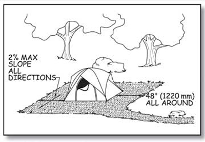
Figure 92—The requirements for a tent pad.
Ensure the surface of an accessible tent pad or platform is firm and stable, can accommodate the use of tent stakes or other devices to secure the tent, and is made of a material that is appropriate for the level of development and setting (figure 93). Where there is a condition for an exception, the surface only has to be as firm and stable as is practicable.
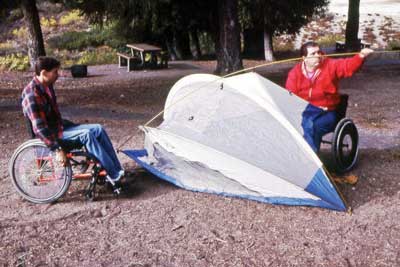
Figure 93—Campers are pitching their tent on a surface that is both accessible and appropriate for the setting.
FSORAG does not require any framed tent platforms or raised tent pads to be constructed. The decision to construct tent pads or tent platforms is a local decision that should be based on what is appropriate for the setting. If tent platforms or raised tent pads are constructed, they must comply with the previously explained clear space, slope, and surface requirements, as well as the following connection requirements.
Accessible surfaces for pitching tents may or may not be at ground level. A level connection that meets outdoor recreation access route standards should be provided to groundlevel [sic] tent floor surfaces. For above-grade platforms or raised tent pads, the outdoor recreation access route may either slope up to the same level as the tent floor surface or end at a clear space that is adjacent to and 17 to 19 inches (430 to 485 millimeters) lower than the tent floor surface. This height is suitable for transferring from a wheelchair to the tent surface.
Benches
Ensure that all benches provided along Forest Service trails or beach access routes or at Forest Service recreation sites (other than those inside a building or in an amphitheater) meet the following requirements. Connect at least 20 percent of benches at a Forest Service recreation area to the area's other major features by an outdoor recreation access route. Benches inside buildings must comply with sections F221.2.1.1, F221.2.2, and 903 of ABAAS. Benches in amphitheaters must comply with the requirements in ABAAS section F221 for assembly areas, including wheelchair spaces, companion seats, designated aisle seats, and lawn seating. Even if most benches in the amphitheater don't have back support, consider providing it at the designated aisle seats required by ABAAS, section F221.4.
Ensure that the front edge of the bench seat is 17 to 19 inches (430 to 485 millimeters) above the ground or floor space. When more than one bench is provided in a common area such as a scenic overlook, at least half of the benches must have back support that runs the full length of the bench
Provide one armrest on at least half of the benches with back support. Consider the visitors who will use a particular area when deciding where to locate an armrest. For people who have difficulty standing up from a seated position, having an armrest can be helpful. However, armrests on both ends of the bench could prevent a person using a wheelchair from being able to transfer onto the bench. A compromise design is a bench with back support and one armrest placed in the middle of the bench. Figure 94 shows a bench that meets these requirements. Another option is to place a single armrest on the end of the bench farthest from the clear floor or ground space.
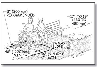
Figure 94—The requirements for benches.
All parts of the bench must be able to withstand 250 pounds (1,112 newtons) applied vertically or horizontally at any point of the seat, fastener, mounting device, or supporting structure. This requirement is the same as the ABAAS requirement for bench strength in section 903.6.
Provide a clear floor or ground space that is 36 by 48 inches (915 by 1,220 millimeters) adjacent to one end of each bench. Do not allow this clear space to overlap the outdoor recreation access route, trail, or beach access route, so that using the bench or clear space doesn't limit travel past the bench and vice versa. Locate the clear space to provide shoulder alignment between a person sitting on the bench and a person seated in a wheelchair occupying the clear space, so that transfers to the bench are convenient and conversations between people on the bench and beside it are comfortable.
Shoulder alignment generally can be achieved by positioning the back of the bench so that it is 8 inches (200 millimeters) closer to the outdoor recreation access route, trail, or beach access route than the back of the required clear floor or ground space adjacent to the end of the bench (see figure 94).
Do not allow the slope of the clear floor or ground space to exceed 1:48 (2 percent) in any direction, except if the surface isn't paved or built with boards, the slope may be up to 1:33 (3 percent) when needed for proper drainage. The surface must be firm and stable and made from a material that is appropriate to the setting and level of development.
If a condition for exception in an alteration project at an existing site prohibits full compliance with a specific requirement for clear floor or ground space (surface, slope, size, or location), the clear floor or ground space only has to comply with requirements to the extent practicable.
Trash, Recycling, and Other Essential Containers
Many recreation areas have trash and recycling containers for visitors' convenience to protect the environment or to discourage visits to the area by wild animals. Some campgrounds also provide bear-resistant food storage containers. Each container must meet the requirements that follow. If containers are provided in a recreation site, connect them to the area's other major features by an outdoor recreation access route. If containers are provided on trails, ensure that routes connecting those containers and the other major constructed features comply with technical requirements for trails rather than outdoor recreation access routes.
In a multibin [sic] container, only half the bins for each purpose must meet the accessibility requirements. For example, if a trash container has four separate compartments, only two of the compartments are required to meet the technical requirements. But all the bins of a recycling container with four separate bins to collect four different types of recyclable materials must meet the requirements. Figure 95 illustrates these requirements.
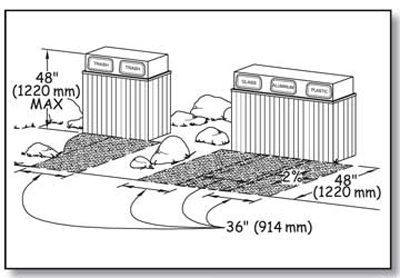
Figure 95—The requirements for trash and recycling containers.
Provide a clear floor or ground space that is either 36 inches (914 millimeters) by 48 inches (1,220 millimeters) positioned for a forward approach or 30 inches (760 millimeters) by 60 inches (1,525 millimeters) positioned for a side approach to the receptacle opening at each container. The clear space may overlap the clear space for adjacent containers. It must be adjacent to and may overlap the outdoor recreation access route. The slope of the clear space must not be steeper than 1:48 (2 percent) in any direction. When the surface is unpaved or not built with boards, slopes not steeper than 1:33 (3 percent) are allowed if necessary for drainage. Ensure the surface is firm and stable and made from a material consistent with the setting and level of development. However, if a condition for exception in an alteration project at an existing site prohibits full compliance with a specific requirement for clear floor or ground space (surface, slope, size, or location), the clear floor or ground space only has to comply with requirements to the extent practicable.
Ensure controls and operating mechanisms for containers comply with the technical requirements for reach ranges and operability specified in ABAAS, sections 308 and 309, and explained in "Reach Ranges and Operability Requirements" of this guidebook.
An exception is allowed for lids and operating controls designed to deter large animals, such as grizzly bears (figure 96). Large animals pose a threat to humans when they become accustomed to wandering through recreation sites in search of food. Most containers equipped with accessible controls and operating mechanisms can be opened by determined bears. Containers in recreation areas where bears and other large animals pose a risk to humans don't have to comply with accessibility provisions for operating controls until accessible bear-proof containers are available from more than one source. Dumpster type trash and recycling receptacles are not required to comply with the operability requirements.

Figure 96—Grizzly bears have the power and persistence to get food that is not secured properly.
Telescopes and Periscopes
Viewing areas are sometimes equipped with mounted telescopes or periscopes to provide the visitor with a better view of a point of interest. Whenever a telescope or periscope is provided, ensure that a separate telescope or periscope is available for use from a standing position (60 inches above the floor or ground surface is suggested) and from a seated position at each distinct viewing location. This allows all visitors to experience views similarly. Telescopes and periscopes that are usable from a seated position will provide the widest range of viewing opportunities for seated individuals, as well as children and people of short stature. The telescopes or periscopes at each location can be mounted separately or on the same pedestal. Telescopes or periscopes for use from a seated position must be connected to the other major constructed features at the recreation area by an outdoor recreation access route and meet the following requirements.
Ensure that controls and operating mechanisms for telescopes and periscopes usable from a seated position comply with the technical requirements for reach ranges and operability specified in ABAAS, sections 308 and 309, as explained in "Reach Ranges and Operability Requirements” of this guidebook. The eyepiece of each telescope or periscope usable from a seated position must be 43 inches (1,090 millimeters) minimum and 51 inches (1,295 millimeters) maximum above the floor or ground surface. Although not required, an adjustable scope mount is ideal for accessible viewing. Figure 97 shows one way to configure an accessible telescope area.
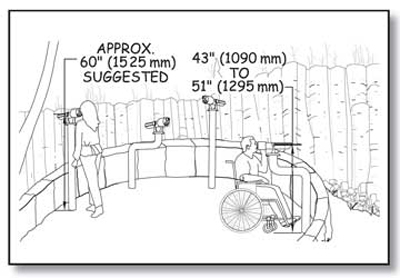
Figure 97—Requirements for viewing areas with telescopes and periscopes.
Provide a clear floor or ground space that is adjacent to (and may overlap) an outdoor recreation access route at all accessible telescopes and periscopes so that someone using a wheelchair or other assistive device can approach and move around them. This maneuvering space must be at least 36 inches by 48 inches (915 millimeters by 1,220 millimeters). Position the clear floor or ground space for a forward approach to the telescope or periscope and so that the eyepiece of the telescope or periscope is centered on the space. Provide knee and toe clearance complying with ABAAS, section 306, under the telescope or periscope (figure 98). Knee space under the telescope or periscope must be at least 30 inches (760 millimeters) wide, 19 inches (485 millimeters) deep, and 27 inches (685 millimeters) high, as measured from the ground or floor to the bottom of the structure that supports the telescope or periscope. Toe clearance of at least 9 inches (230 millimeters) above the ground or floor must extend at least an additional 6 inches (150 millimeters) beyond the required knee clearance.
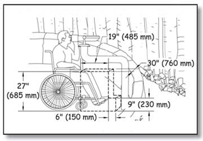
Figure 98—Requirements for knee and toe space at telescopes and periscopes.
Utilities at Recreation Sites
In general, connect electricity hookups, drinking water faucets, outdoor rinsing showers, utility sinks, sewer hookups, and other utilities that are provided in recreation sites to the other major constructed features at the recreation area by an outdoor recreation access route and ensure they meet the following requirements. However, if a condition for exception in an alteration project at an existing site prohibits full compliance with a specific requirement for clear floor or ground space (surface, slope, size, or location), the clear floor or ground space only has to comply with requirements to the extent practicable.
Ensure controls and operating mechanisms for utilities comply with the technical requirements for reach ranges and operability specified in ABAAS, sections 308 and 309, which are explained in "Reach Ranges and Operability Requirements” of this guidebook. Sewage hookups don't have to comply with the reach ranges of ABAAS, section 308 or operation requirements of section 309, but the slope and surface requirements must still be met.
Provide a clear floor or ground space of at least 30 by 60 inches (760 by 1,525 millimeters) oriented for front or parallel approach to all usable sides of utilities, except at water hydrants and outdoor rinsing showers. Hydrants and showers have their own requirements that are explained after this section. One full side of the clear floor or ground space around utilities must be adjacent to or overlap the outdoor recreation access route. The clear space also may overlap adjacent clear spaces. Figures 99 and 100 illustrate this requirement.
Figure 99—This illustration of an electrical connection shows the requirements for campground utilities.
Figure 100—The clear space for utilities can overlap at campsites.
Ensure the slope of the clear space required at utilities and water hydrants does not exceed 1:48 (2 percent) in any direction. When the surface is unpaved or not built with boards, grades up to 1:33 (3 percent) are allowed if needed for proper drainage. The surface of the clear space must be firm, stable, and made of a material that is appropriate to the level of development and setting.
Ensure openings in the surface of the clear floor or ground spaces are not big enough to allow passage of a sphere more than a half of an inch (13 millimeter) in diameter. Place elongated openings more than a quarter of an inch wide with the long dimension perpendicular to the primary direction of travel.
Water Hydrants
Water hydrants, including water faucets on posts and handpumps are the outdoor devices from which people obtain drinking water. The opening where the water discharges is called a water spout. Locate water spouts between 28 inches (710 millimeters) and 36 inches (915 millimeters) above the ground or floor surface on the edge of a clear space that is at least 72 inches (1,830 millimeters) by 48 inches (1,220 millimeters). This clear space must be located with its long side adjoining (and may overlap) an outdoor recreation access route, trail, beach access route, or another clear ground space. This permits a forward or parallel approach to the water spout and allows enough room for someone in a wheelchair to turn around and leave. Locate water spouts 11 inches (280 Applying the Forest Service Outdoor Recreation Accessibility Guidelines 68 Constructed Features in Recreation Sites millimeters) [sic] minimum and 12 inches (305 millimeters) maximum from the rear center of the long side of the clear space. The requirements for the surface and slope of the clear space are the same as for other utilities.
If the water hydrant is an unusual design with the handle and spout on different sides of the post, be sure that people can access both sides. In addition, if drainage grates are provided, ensure that the openings in the grates comply with the outdoor recreation access route provision for openings. Figure 101 illustrates these requirements.
Figure 101—The requirements for water hydrants.
Standard handpumps require a force greater than 5 pounds (2.2 newtons) and a long reach to operate. Until handpumps that meet the accessibility standard for operating controls while adequately accessing the water supply are available from more than one source, handpumps are exempt from the requirements for reach ranges and operability in ABAAS, sections 308 and 309.4.
The Forest Service's technology and development program has produced an accessible handpump that can be used when a well is 40 feet (12 meters) deep or less. This pump should be considered for new or replacement shallow well installations when the accessible pump meets the technical specifications for the water supply. A deeper well pump is under development. Information about the commercially manufactured accessible handpumps (figure 102) is available on the Forest Service's internal computer network at http://fsweb.mtdc.wo.fs.fed.us/programs/eng/handpump.htm or on the World Wide Web at http://www.fs.fed.us/recreation/programs/accessibility.
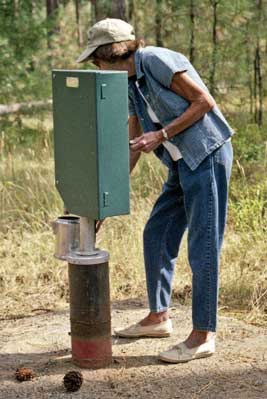
Figure 102—An accessible handpump developed by the Missoula Technology and Development Center.
Clean water tests, energy efficiency, and accessibility compliance can be achieved at most locations using solar powered pumps. The Superior National Forest in northern Minnesota (see figure 18) and the Okanogan-Wenatchee National Forest in eastern Washington (figure 103) are among the forests that have successfully used solar pump systems for a number of years in campgrounds and picnic areas of all sizes. The water spout control for solar pumps easily can be designed to require 5 pounds (2.2 newtons) of pressure or less using one closed fist (figure 104) to provide a sustainable flow of accessible water.
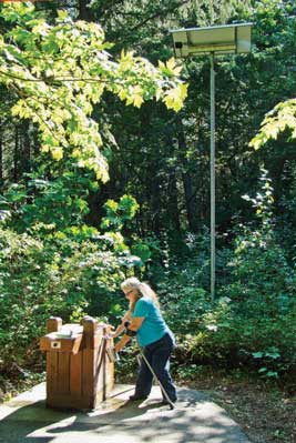
Figure 103—Solar water pumps and batteries can be housed in small pedestal enclosures and powered by solar panels on an adjacent pole.
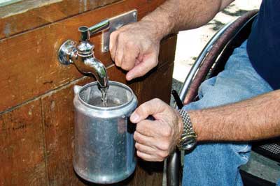
Figure 104—A solar pump provides pressure for this water spigot. A camper uses accessible controls to fill his coffee pot.
Outdoor Rinsing Showers
Outdoor showers permit people to rinse off sand, dirt, and debris. They are not intended for bathing. They generally don't offer privacy, and people usually are not permitted to disrobe when using them.
If outdoor rinsing showers are provided in a recreation site, provide at least one hand-held shower spray unit with a hose 59 inches (1,500 millimeters) long minimum. The hand-held shower spray must have at least one fixed position located 15 inches minimum (380 millimeters) and 48 inches (1,220 millimeters) maximum above the clear ground space. Because hand-held showerheads are vulnerable to vandalism and breakage, they are not a durable design choice for some recreation sites. In these cases, provide a low shower accessible to someone in a seated position and a high shower accessible to someone who is standing (figure 105). Both showers must meet the clear floor and ground space and outdoor recreation access route requirements that follow. For a low outdoor rinsing shower, mount a fixed showerhead 48 inches (1,220 millimeters) above the ground or floor. For a high outdoor rinsing shower, mount a fixed showerhead at least 72 inches (1,830 millimeters) above the ground or floor. If self-closing controls or operating mechanisms are used, the controls must remain open for at least 10 seconds.
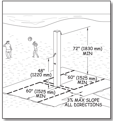
Figure 105—The requirements for outdoor rinsing showers.
Each accessible outdoor rinsing shower must have a clear floor or ground space at least 60 inches by 60 inches (1,525 millimeters by 1,525 millimeters). Locate the clear space so that the shower pedestal or wall to which the showerhead is attached is at the center back of the clear space so that the water from the showerhead is directed toward the center of the clear space. The requirements for surface, slope, and openings in the clear space are the same as for other utilities. Accessible outdoor rising showers must be connected to the area's other major features by an outdoor recreation access route.
Utility Sinks
A utility sink is deeper than a standard restroom basin or kitchen sink and can be used to clean large pots or equipment. Usually, utility sinks are provided only in highly developed recreation areas. If utility sinks are provided in a recreation facility that also contains a cook top or conventional range, at least 5 percent (but not less than 1) in each accessible room or space must comply with the following requirements. Utility sinks don't have to comply with these requirements if they're located in a space without a cook top or range.
Ensure that the height of the counter or rim surrounding the utility sink is not more than 34 inches (865 millimeters) above the ground or floor space and that the bottom of the bowl is at least 15 inches (380 millimeters) above the ground or floor space. The requirements for surface, slope, and openings in the clear space are the same as for other utilities.
If hot water is provided, wrap or shield the pipes to prevent someone from accidentally coming in contact with hot pipes. Ensure that sink controls and operating mechanisms comply with the technical requirements for reach ranges and operability specified in ABAAS, sections 308 and 309, and that water spouts are 28 inches (710 millimeters) to 36 inches (915 millimeters) above the ground or floor. Figure 106 illustrates these requirements.
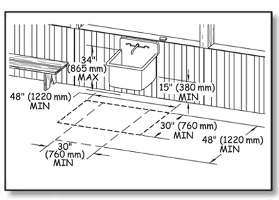
Figure 106—The requirements for utility sinks.
Buildings in Recreation Sites
Permanent buildings with walls, roof, and a door at recreation areas must meet all the applicable provisions of ABAAS, as well as those of other applicable building codes.
However, some buildings are only found in the outdoor recreation environment, such as camp shelters and pit toilets. Accessibility requirements for those buildings are explained below.
Camp Shelters
Camp shelters are small structures typically enclosed on three sides with a roof or overhang. They are often located on trails. Figure 107 shows a typical camp shelter that provides some protection from the weather. Camp shelters aren't cabins. Cabins are typically fully enclosed and must comply with ABAAS, section 806 for transient lodging.
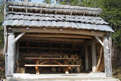
Figure 107—The entrance to the Three Lakes camp shelter at the Tongass National Forest is level with the ground.
Ensure that each camp shelter meets the following requirements, except in two circumstances. If a condition for an exception prohibits full compliance with a specific technical requirement in FSORAG, section 5.1, the camp shelter only has to comply with the specific requirement to the extent practicable. When more than two camp shelters are grouped together in a camping unit, only 20 percent of them (but never less than two) are required to meet the requirements. For example, if five camp shelters are grouped, 20 percent is one shelter. Because of the minimum number required, however, this group must include at least two shelters that meet the requirements. However, in a group of 15 shelters, 20 percent is 3 shelters. At the least, three shelters must meet the requirements. Remember that the requirements are minimums, and the Forest Service commitment to universal design dictates that as many shelters as is practicable should meet the requirements.
Connect camp shelters located on trails to the other constructed features at the site by a trail that meets the technical requirements in FSTAG. Connect camp shelters that are located in a campground and are not on a trail to other constructed features in the camping unit and to the common use features that are provided at the campground, such as toilets, showers, water hydrants, garbage receptacles, parking spaces, and beach access by an outdoor recreation access route.
Provide a clear floor or ground space at least 36 inches (915 millimeters) by 48 inches (1,220 millimeters) at the entrance to the camp shelter. The long side of the clear floor or ground space must be parallel to the camp shelter entrance. One full, unobstructed side of the clear ground space must adjoin or overlap the trail or outdoor recreation access route (as applicable) or another clear ground space. When a condition for an exception prohibits full compliance with the clear ground requirement, the clear ground space only has to comply to the extent practicable.
Ensure that the surface of the clear floor or ground space at the open entrance side of the shelter and the floor of the shelter is firm, stable, and does not slope more than 2 percent (1:48) in any direction. However, when the surface is unpaved or not built with boards, slopes 5 percent (1:20) or less are allowed if necessary for drainage.
When the floor at the entrance to the camp shelter is raised above the ground, ensure that the floor is 17 inches (430 millimeters) minimum to 19 inches (485 millimeters) maximum, higher than the adjoining clear space at the open entrance side (figure 108). This height must be maintained for a length of at least 48 inches (1,220 millimeters) beside the clear space so that someone using a wheelchair or other assistive device can transfer to the floor of the shelter.
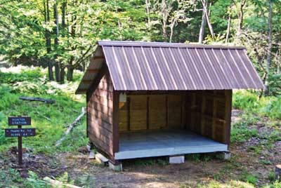
Figure 108—The entrance to the Hunter Station camp shelter at the Allegheny National Forest is raised above the ground.
If the camp shelter has a level entry, provide a turning space that is 60 inches (1,525 millimeters) minimum in diameter (see figure 62) or is T-shaped with a minimum 60- by 36-inch (1,525- by 915-millimeter) arm and a minimum 36-inch (915-millimeter) -wide by 24-inch (610-millimeter) -long base (see figure 63) inside the camp shelter. This requirement is the same as ABAAS, section 304.3. The clear space and turning space allows someone using a wheelchair or other assistive device to approach and move about the camp shelter.
The floor surface within the camp shelter must be firm and stable and must not slope more than 2 percent (1:48) in any direction. If amenities such as tables or wood stoves are provided in camp shelters, they must meet the requirements of FSORAG, section 5.
Toilet Buildings and Pit Toilets
Toilet buildings are provided for visitor convenience and comfort in recreation sites that meet the criteria for level 3 or higher on the recreation site development scale. Vault toilets, flush toilets, or composting toilets are typical at these sites. Regardless of the waste disposal system or design of the building, make sure they meet the requirements of ABAAS. Specifically, toilet buildings at developed recreation sites with only one riser must comply with the requirements for toilet room size and clearances in section 603 of ABAAS and with the requirements for toilet seats, grab bars, controls, and dispensers in sections 604.4, 604.5, 604.6, and 604.7 of ABAAS. Toilet buildings with multiple risers must comply with all of section 604 of ABAAS. If washing sinks, showers, or other amenities are provided in toilet buildings, or separate changing or shower buildings, they must also comply with the appropriate sections of ABAAS. When designing toilet buildings, be careful not to confuse the requirements for toilet stalls with those for single riser toilet rooms.
Pit toilets are located in remote areas. They are provided primarily for resource protection, rather than for visitor convenience and comfort. Pit toilets are primitive outhouses that may consist simply of a hole dug in the ground covered by a toilet riser (figure 109). The pit toilet riser may or may not be surrounded by walls and may or may not have a roof. Pit toilets may be permanent installations or they may be moved from one location to another as the hole is filled or the area has become overused. Waste disposal in pit toilets may be directly into the ground (pit) or may include moldering or composting processes.
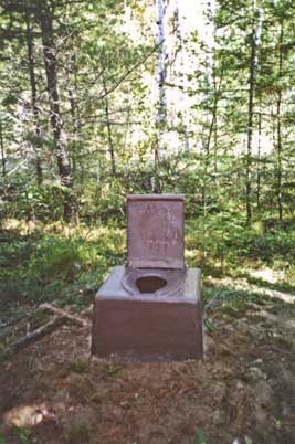
Figure 109—A fiberglass riser for a pit toilet in the Boundary Waters Canoe Area.
Do not confuse pit toilets with toilet buildings. Pit toilets are only provided in low development areas where it has been determined that they are necessary for resource or environmental protection. Pit toilets are never appropriate in a Forest Service recreation site with a development scale level of 3 or higher.
Ensure each pit toilet meets the following requirements and is connected to the area's other major constructed features by an outdoor recreation access route. Connect pit toilets that are provided on trails to the area's other major constructed features by a route that complies with the trail specifications rather than an outdoor recreation access route.
The design of pit toilets varies widely depending on the setting, the amount of expected use, and the system used to manage the waste. If an accessible pit toilet has walls, a floor, a door, or a roof, these components must comply with the appropriate provisions of ABAAS as follows.
If the pit toilet has a riser and toilet seat, ensure that the total height of that seat and the riser it rests on is 17 to 19 inches (430 to 485 millimeters) above the ground or floor.
If the pit toilet has lightweight privacy screens or has no walls, ensure that the riser has vertical or nearly vertical sides and a flat area on each side of the seat that is about 3 inches (75 millimeters) wide.
For pit toilets with lightweight privacy screens or no walls, provide a clear floor or ground space that is at least 60 inches (1,525 millimeters) wide and 56 inches (1,420 millimeters) deep. Of the required width of clear floor space, ensure that only 16 to 18 inches (405 to 455 millimeters) is on one side of the centerline of the riser; the rest must be on the other side. The depth of the clear space is measured from the back of the riser and extends in front of the riser (figure 110). If these clear space requirements can't be met due to a condition for an exemption, then the clear space must meet the technical requirements to the extent practicable.
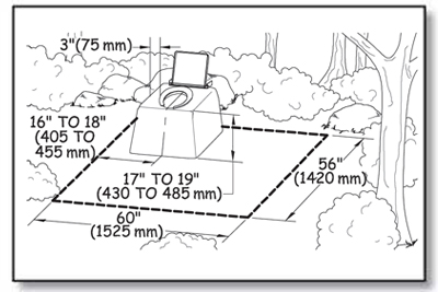
Figure 110—The requirements for clear space at an unenclosed toilet.
If there are sturdy walls around the pit toilet riser, standard riser dimensions, placement, and grab bars are required as shown in ABAAS, sections 603, 604, and 609. Grab bar size, strength, finish, and position requirements are explained in "Grab Bars" of this guidebook.
Grab bars must comply with the reach ranges required in ABAAS, section 308, and explained in "Reach Ranges and Operability Requirements" of this guidebook. As required in ABAAS, section 604.5, grab bars for toilets must be installed in a horizontal position, 33 to 36 inches (840 to 915 millimeters) above the finished floor, measured to the top of the gripping surface.
Ensure the grab bar beside the riser is at least 42 inches (1,065 millimeters) long, is located no more than 12 inches (305 millimeters) from the wall behind the toilet, and extends at least 54 inches (1,370 millimeters) from the rear wall. The grab bar behind the riser must be at least 36 inches (915 millimeters) long and extend from the centerline of the water closet at least 12 inches (305 millimeters) on the side closest to the side wall grab bar and at least 24 inches (610 millimeters) on the other side (figure 111).
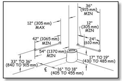
Figure 111—The grab bar placement requirements for pit toilets enclosed by walls.
For pit toilets enclosed by walls, make sure the back of the riser is against the wall behind the riser. Provide a clear floor space that is at least 60 inches (1,525 millimeters) wide and 56 inches (1,420 millimeters) deep around the toilet.
Of the required width of clear floor space, ensure that only 16 to 18 inches (405 to 455 millimeters) on one side of the centerline of the riser, and the rest is on the other side. Provide turning space of at least 60 inches (1,525 millimeters) in diameter or T-shaped with a minimum 60- by 36-inch (1,525- by 915-millimeter) arm and a minimum 36-inch (915-millimeter) -wide by 24-inch (610-millimeter) -long base. This requirement is the same as ABAAS, section 304.3. Portions of the turning space may overlap the toilet clear floor space (figure 112).
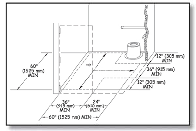
Figure 112—The requirements for a T-shaped turning space for a pit toilet enclosed by walls.
When there are walls, ensure doorways or wall openings that provide entrance to the toilet have a minimum clear width of 32 inches (815 millimeters), in compliance with ABAAS, section 404.2.3. Door swings must not obstruct the clear floor space inside the pit toilet. Doors that open out or slide use space efficiently to provide the required interior clear space, but they are not allowed to block the access route to the building. Ensure door hardware, such as handles, pulls, latches, and locks, complies with the technical requirements for reach ranges and operability specified in ABAAS sections, 308 and 309 and explained in "Reach Ranges and Operability Requirements."
Construction Tip
Do not use grab bars with privacy screens.
Lightweight privacy screens are sometimes provided for pit toilets in remote general forest areas. Screens may be provided in areas where vegetation or terrain doesn't provide enough privacy but where walls or sturdier enclosures would significantly change the recreational setting or adversely impact significant natural features or where it is difficult and expensive to pack in conventional construction materials. These screens may be made from tent fabric or other lightweight materials and have only enough structural strength to stay upright.
Never attach grab bars to privacy screens. Screens do not have enough strength to support a 250-pound (1,112-newton) load on the grab bars. Instead, position the screens outside the clear area required around the toilet to allow unobstructed access to the toilet area.
Design Tip
Edge protection may be used for inclines in outdoor recreation environments.
Edge protection is a raised curb, wall, railing, or other structure that defines the edge of a travel surface and helps keep people on the travel surface. Edge protection is not required for accessibility, and it is not usually desirable in outdoor environments. However, edge protection may be desirable for safety or other reasons; it should be a little higher in an outdoor environment than in an urban environment. It isn't as easy to see or detect objects near the ground in an outdoor environment, so edge protection curbs should be at least 3 inches (76 millimeters) high (see figure 46).
Whether the pit toilet has walls or not, make sure the slope of the turning space and the clear floor or ground space does not exceed 1:48 (2 percent) in any direction. When the surface is unpaved or not built with boards, grades 1:33 (3 percent) or less in any direction are allowed if required for proper drainage. Provide a surface that is firm, stable, and made from material appropriate to the setting and level of development. When there is a condition for an exception that prohibits full compliance with the slope or surface requirements, they only have to be met to the extent practicable.
Locate the entrance to each pit toilet at ground level wherever possible. For instance, composting and moldering toilets have a "basement" area where waste is processed. The need to service the area under the riser may make it difficult to provide a ground level entrance to the toilet. In other areas, surface bedrock, permafrost, or other ground conditions make it difficult to dig a pit. In situations where the pit toilet is elevated above the ground surface, make sure any inclined access from the connecting outdoor recreation access route or trail to the entrance of the toilet structure is firm and stable, at least 36 inches (915 millimeters) wide, and not more than a 1:12 (8.33 percent) slope to the extent practicable. If an inclined connection meeting these requirements isn't practicable because of a condition for exception, steps are permitted—but only as a last resort. Provide a landing at least 60 inches by 60 inches (1,220 millimeters by 1,220 millimeters) outside the entrance door to the toilet structure. Because it is an outdoor recreation environment, make sure the inclined surface is firm and stable. It doesn't have to be slip-resistant, and handrails aren't required.
Getting to the Water—Beach Access Routes
Beach access routes allow pedestrians to get across the beach so they can play, swim, or participate in other beachrelated [sic] activities. A beach access route is a continuous unobstructed path that crosses the surface of the beach and provides pedestrian access to the water. Section 6 of FSORAG explains the requirements for beach access routes. Because beach access routes and outdoor recreation access routes perform similar functions, the requirements are similar.
Beaches are grouped into three general types:
-
Tidal beaches (figure 113)
-
River beaches (figure 114)
-
Lake, pond, and reservoir beaches (figure 115)

Figure 113—The high tide level at a coastal beach.
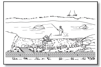
Figure 114—The mean high water level at a river.

Figure 115—The normal recreation water level at a lake.
Beach access routes must extend from an outdoor recreation access route or other beach entry point to the high tide level at tidal beaches, mean high water level at river beaches, and the normal recreation water level at lake, pond, and reservoir beaches.
Beach access routes are required when dune crossings, stairways, or ramps leading from boardwalks to the beach are constructed or altered; when parking facilities, pedestrian routes, toilet facilities or bathing facilities that serve the beach are constructed or altered; or when a beach nourishment project is undertaken. They must coincide with or be located in the same area as other pedestrian access to the beach. Employ universal design wherever possible so that all visitors use the same route to get to the water (figure 116).
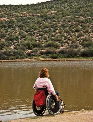
Figure 116—Everybody ought to be able to get to the beach.
When beach access routes are required, provide them for each half mile of managed shoreline. However, the number of beach access routes doesn't have to exceed the number of pedestrian beach access points that are provided. Beach access routes are not required where pedestrian access to the beach is not allowed. Beach access routes associated with beach nourishment projects are only required up to an expenditure of 20 percent of the costs of the beach nourishment project.
Removable beach access routes can be moved to a protected storage area during storms and other periods when the routes are subject to damage. Removable beach access routes are not required to comply with the slope and resting interval technical requirements. Use temporary beach access route surfaces as necessary where restrictive permits are required in coastal and shoreline areas where seasonal tides or high flows would remove a permanent structure, or in areas where the beach erodes or builds up each season, quickly turning a permanent beach access route into a hazard. Vehicular access or access provided by an assistive device isn't an acceptable temporary beach access route.
Design Tip
Extend beach access routes to a reasonable point on the beach.
Access to the water at tidal beaches will vary considerably depending on geographic locations because the difference between low and high tides will vary from place to place. For example, a beach in Alaska may experience tidal differences of up to 30 feet (9 meters); beaches in Florida will have much smaller differences between the tides. The high tide mark is a reasonable location to stop constructed features; they are much more likely to wash out below this point. The same general guidance applies to mean high water level at rivers and the normal recreation water level at lakes.
In some locations, it may make sense to continue the beach access route below the mean high water level or normal recreation water level. In locations with significant variations in water level through the recreation season, visitors appreciate extended access routes where they can be constructed (figure 117).
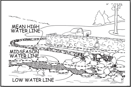
Figure 117—Some beach access routes are partly inundated every year.
Exceptions to the Guidelines That Apply to Beach Access Routes
When a condition for an exception prohibits full compliance with a specific technical requirement on a portion of a beach access route, that portion of the beach access route must still comply with the requirement to the extent practicable. (See "Using the Conditions for an Exception in FSORAG.") Document the reason that full compliance wasn't achieved and file it with the project records for the construction or alteration project.
Notifying the U.S. Access Board About Exemptions
Infrequently, an entire beach access route must be exempted from the technical requirements because extreme or numerous conditions for exemptions make it impractical to provide a route that meets the requirements. In these cases, document the reason for the exemption, the date of the decision, and the names of the individuals who made the decision. Retain documentation with the records for the construction or alteration project. Notify the U.S. Access Board of the determination and the reason for that decision. Contact information for the U.S. Access Board is available at http://www.access-board.gov/
The U.S. Access Board has drafted a form that may be used to document and submit an exemption decision. The form will be available at http://www.access-board.gov/guidelines-and-standards/recreation-facilities/outdoor-developed-areas when the U.S. Access Board final guidelines are published.
Surface and Clear Tread Width on Beach Access Routes
A beach access route must have a firm, stable surface, and have a clear tread width of 60 inches (1,525 millimeters) minimum.
Slopes and Resting Intervals for Beach Access Routes
Running slope, also referred to as "grade," is the lengthwise slope of a beach access route, parallel to the direction of travel. Sections of beach access route of any length are allowed to have a running slope ratio of up to 1:20 (5 percent grade) (see figure 37). Steeper terrain may make this slope difficult to achieve. Many visitors can negotiate steeper slopes for short distances, so running slopes up to 1:12 (8.33 percent) are permitted for up to 50 feet (15 meters), and running slopes of up to 1:10 (10 percent) are permitted for up to 30 feet (9 meters). To ensure that the beach access route isn't designed as a series of steep segments, no more than 15 percent of the total length of the beach access route may exceed a slope of 1:12 (8.33 percent), as shown in table 4.
Table 4—Beach access route running slope and segment length.
| Running Slopes on Beach Access Routes | Maximum Length of Segment Between Resting Intervals | |
|---|---|---|
| Steeper than | But not Steeper than | |
| 1:20 (5 percent) | 1:12 (8.33 percent) | 50 feet (15 meters) |
| 1:12 (8.33 percent) | 1:10 (10 percent) | 30 feet (9 meters) |
Cross slopes—the side-to-side slope of a beach access route—are not allowed to exceed 1:33 (3 percent, see figure 37). When the surface is paved or is built with boards, the cross slope is not allowed to be steeper than 1:48 (2 percent).
Resting intervals are relatively level areas that provide an opportunity for people to catch their breath before continuing along the beach access route. These intervals are required between each segment of the beach access route any time the running slope exceeds 1:20 (5 percent). A resting interval must be at least 60 inches (1,525 millimeters) by 60 inches (1,525 millimeters).
The slopes of a resting interval are not allowed to exceed 1:33 (3 percent) in any direction. When the surface is paved or is built with boards, the slope is not allowed to be steeper than 1:48 (2 percent) in any direction.
Tread Obstacles on Beach Access Routes
Tread obstacles on a beach access route must not be more than 1 inch (25 millimeters) high. When the surface of the beach access route is paved or is built with boards, tread obstacles must not be more than a half of an inch (13 millimeters) high. Where possible, ensure obstacles on beach access routes are separated by at least 48 inches (1,220 millimeters) so people who use wheelchairs can maneuver around the obstacles.
Openings in Beach Access Routes
Openings are gaps in the surface of a beach access route. Gaps include spaces between the planks on a boardwalk and drainage holes in temporary or permanent surfaces. Openings that are big enough to allow wheels, cane or crutch tips, or shoe heels to drop through or get stuck are hazards that shouldn't exist in pedestrian routes. Openings up to a half of an inch (13 millimeters) wide are permitted. Place elongated openings more than a quarter of an inch wide with the long dimension perpendicular or diagonal to the primary direction of travel (see figure 44).
Protruding Objects on Beach Access Routes
Outdoor accessibility guidelines define protruding objects as constructed features such as signs that extend into the clear width area of a beach access route or resting interval and are between 27 inches (685 millimeters) and 80 inches (2,030 millimeters) above the travel surface. Do not allow constructed features to extend more than 4 inches (100 millimeters) into the clear width area (see figure 45). Constructed features that extend into the travel way of a beach access route from the side or from overhead can be hazardous to people who are paying more attention to their companions than the travel route, as well as to people who are blind or have low vision.
Accessibility guidelines do not consider natural elements such as tree branches and rock formations to be protruding objects. Provide and maintain clearance from natural elements around beach access routes in accordance with your unit's standards; keep in mind overhanging hazards to people who are blind or have low vision or are not focused on the route ahead.
Elevated Dune Crossings
An dune crossing that is elevated or has a slope that exceeds 1:20 (5 percent) that is part of a beach access route must have handrails and edge protection (figure 118). Locate handrails continuously along both sides of the dune crossing at a height of 34 inches (865 millimeters) to 38 inches (965 millimeters) above the walking surface. Ensure the handrails are easy to grip and comply with all the other requirements in ABAAS, section 505. Provide a curb or barrier directly under the handrail that would prevent a 2-inch (50-millimeter) sphere on, or up to 2 inches (50 millimeters) above, the dune crossing surface from rolling under the handrail. The clear width of elevated dune crossings may be narrower than the rest of the beach access route, but must be at least 48 inches (1,220 millimeters). Resting intervals are not required on elevated dune crossings. Consider including resting intervals similar to those for outdoor recreation access routes if the elevated crossing is steeper than 1:20 (5 percent).
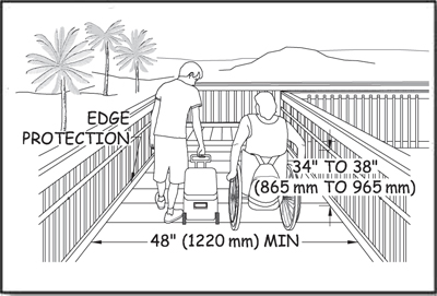
Figure 118—The requirements for width, handrails, and edge protection onan elevated beach access route.
Gates and Barriers on Beach Access Routes
If gates or barriers are constructed to control access to beach access routes, include openings wide enough to allow hiker passage. Refer to the FSORAG for the technical provisions for gates and barriers. These requirements are also explained in "Getting From Here to There—Outdoor Recreation Access Routes" of this guidebook.
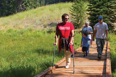
Applying the Forest Service Trails Accessibility Guidelines
The first step in applying the Forest Service Trails Accessibility Guidelines (FSTAG) is to know when and where compliance is required. Section 7.0 "Application" states that FSTAG applies to trails in the National Forest System that meet all three of the following criteria:
-
The trail is new or altered.
-
The trail has a "Designed Use" of "Hiker/Pedestrian" as defined in the Federal Trail Data Standards.
-
The trail connects either directly to a trailhead or to a trail that meets most of the accessibility requirements.
FSTAG doesn't apply to existing trails unless there is a change in the purpose, intent, or function of the trail—an alteration, in other words. It doesn't apply to trails designed for all-terrain vehicle (ATV), equestrian, or any other nonpedestrian use. FSTAG only applies to trails that have been designed for "Hiker/Pedestrian" use in accordance with the Federal Trail Data Standards (FTDS). Information about FTDS is available at http://www.nps.gov/gis/trails/.
FSTAG doesn't prescribe different "levels of accessibility" based on trail class or any other grouping criteria. FSTAG provides guidance for maximizing accessibility, while recognizing and protecting the unique characteristics of the natural setting, level of development, and purpose of each trail.
Cost is not a valid reason for failing to make a trail accessible. (See BUDGET TIP—Extra cost is not an excuse., page 31.) FSTAG won't apply to most portions of existing primitive, long-distance trails. It may, however, apply to new segments that pass through developed areas. FSTAG recognizes, however, that there is no real benefit in making a newly constructed or altered trail in the backcountry accessible if the only way to get to it is by using an existing trail that isn't accessible and probably can't be made accessible.
By applying FSTAG, you will ensure that the full range of trail opportunities continues to be provided. Hiking opportunities to highly developed interpretive trails, popular scenic overlooks, and more remote areas will be options for everyone (figure 119).
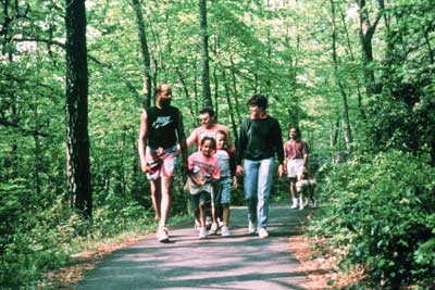
Figure 119—Compliance with the trail accessibility guidelines allows everyone to enjoy hiking.
Trails Are Not Outdoor Recreation Access Routes
An outdoor recreation access route is a continuous, unobstructed path designated for pedestrian use that connects pedestrian elements within a recreation site, such as a picnic area, camping area, or trailhead. In contrast, a trail is defined for purposes of Forest Service Outdoor Recreation Accessibility Guidelines (FSORAG) and FSTAG as a route that is designed, constructed, or designated for recreational pedestrian use or provided as a pedestrian alternative to vehicular routes within a transportation system. A trail is not an outdoor recreation access route and is not subject to the requirements for outdoor recreation access routes found in section 2.0 of FSORAG. This guidebook explains the accessibility requirements for trails designed for hiker and pedestrian use.
Trail Terminology
Although this guidebook explains requirements in plain language, some phrases and words are important to understanding how FSTAG is applied. The following terminology isn't organized alphabetically; the phrases and words are grouped so that the distinctions between similar terminology are easy to understand.
Federal Trail Data Standards (FTDS) enable national-, regional-, State-, and trail-level managers, and the public, to use mutually understood terminology for recording, retrieving, and applying spatial and tabular information. FTDS make it easier for trail information to be accessed, exchanged, and used by more than one individual, agency, or group. The data standards are available at http://www.nps.gov/gis/trails/Doc2/Federal_Trail_Data_Standards_Final_20111108.pdf.
Designed Use is the "Managed Use" of a trail that requires the most demanding design, construction, and maintenance parameters. In conjunction with the applicable "Trail Class," designed use determines which design parameters will apply to a trail. It is an FTDS term for the intended use that controls the geometric design of a trail and determines the level to which it should be maintained. There is only one "Designed Use" per trail or trail segment. Although the trail may be actively managed for more than one use, the designed use determines the technical specifications for the trail. For example, pack and saddle stock require higher and wider clearances than do hikers, so a trail managed for both foot travel and horse use would have a designed use of "Pack and Saddle" rather than "Hiker/Pedestrian." More information about trail design parameters for the different designed uses is in Forest Service Trail Design Parameters, available at http://www.fs.fed.us/recreation/programs/trail-management/trail-fundamentals/ or available to Forest Service employees at http://fsweb.wo.fs.fed.us/rhwr/ibsc/docs/trails/national_design_parameters_2008-10-16.doc.
Managed Use is an FTDS term for the mode(s) of travel for which a trail is actively managed. Managed Uses are the specific types of trail use that are allowed by management decision or intent on a specific trail or portion of a trail. Each trail or trail segment may have more than one "Managed Use." For example, a trail may be managed for both equestrian and hiker/pedestrian use in the summer and for cross-country skiing in the winter.
Constructed Features are commonly found along trails or as part of trails.
-
Associated Constructed Feature—A constructed element associated with a trail that provides support for trail users but is not a part of the trail tread. Examples include camp shelters, pit toilets, fire rings, picnic tables, and tent pads. Refer to FSORAG for the technical provisions for associated constructed features.
Trail Constructed Feature—A constructed feature that functions as part of the trail tread. Examples include puncheon, trail bridges, boardwalks, waterbars, and switchbacks. For a listing of trail constructed features, refer to the trail documentation available at http://www.fs.fed.us/recreation/programs/trail-management/index.shtml or available to Forest Service and Bureau of Land Management employees at http://fsweb.wo.fs.fed.us/rhwribsc/tr-cost.shtml.
A trailhead (for purposes of FSORAG and FSTAG) is a site designed and developed by the Forest Service or other Government agency, a trail association, trail maintaining club, trail partner, or other cooperators to provide a staging area for a trail.
For purposes of FSTAG, trailheads are not:
-
Junctions between trails where there is no other access
-
Intersections where a trail crosses a road or where users have developed an access point, but no improvements are provided by the Forest Service, trail associations, trail maintaining clubs, trail partners, or other cooperators beyond minimal markers or modifications for health and safety
Trail Classes broadly organize trails by desired management characteristics and the level of development. They are based on forest plan direction and represent intended design and management standards. Trail classes take into account user preferences, the setting, protection of sensitive resources, and management activities. Trail classifications range from Trail Class 1 trails that appear little different from animal paths and may disappear intermittently, to Trail Class 5 trails that are usually wide, paved paths associated with highly developed environments. FSTAG does not change Forest Service trail classes. More information about trail classes is available at http://www.fs.fed.us/recreation/programs/trail-management/trail-fundamentals/.
Setting is the word used to describe the nature of the surroundings of a trail. On public lands outside rural and urban settings, the natural surroundings are usually the primary attraction for visitors. Improvements, such as trails, should not adversely affect the setting. For example, the design for a trail crossing a glacial boulder field must protect the geologic features. Accessibility is incorporated to the extent possible without fundamentally altering the natural environment. On the other hand, a trail designed for a wide open, relatively level area should follow the requirements of FSTAG to the highest degree possible.
The following words describe construction and maintenance work:
-
Construction is building a new trail or segment of trail where there was no trail before.
-
An alteration is work done to change the purpose, intent, or function of the trail.
-
Maintenance is the routine or periodic repair of existing trails or trail segments to restore them to the standards or conditions to which they were originally designed and built. Maintenance does not change the original purpose, intent, or function for which the trail was designed. Trail maintenance work isn't covered by the FSTAG. Maintenance includes:
-
Removing debris and vegetation, such as fallen trees or broken branches on the trails, clearing the trail of encroaching brush or grasses, and removing rock slides
-
Maintaining trail tread, such as filling ruts, reshaping a trail bed, repairing a trail surface or washouts, installing riprap to retain cut and fill slopes, and constructing retaining walls or cribbing to support trail tread
-
Performing erosion control and drainage work, such as replacing or installing drainage dips or culverts, and realigning sections of trail to prevent erosion or to avoid boggy areas
-
Repairing or replacing deteriorated, damaged, or vandalized trail or trailhead structures or parts of structures, including sections of bridges, boardwalks, information kiosks, fencing, and railings; painting; and removing graffiti
-
While FSTAG doesn't apply to maintenance, Forest Service policy is to improve accessibility wherever the opportunity arises, including during trail maintenance and repair activities. Every time a trail is maintained, there is an opportunity to improve access.
The word "reconstruction" is not used in Federal accessibility guidelines or FSTAG, even though the term is used frequently by the trails community. For the purposes of FSTAG, actions are categorized as construction, alteration, or maintenance.
Terminology Tip
What do you call a reroute?
If trail work is grouped into only three categories— construction, alteration, and maintenance—what category do things like rerouting, reconstruction, and extensions of existing trails fall into? The key to answering this question is to concentrate first on the definition of alterations. Does the new work change the purpose, intent, or function of the trail? In other words, will the trail serve a new destination? Will the trail's designed use change from horses to hikers, for example, after you're done? Are you significantly changing the overall trail grade, width, or surface, or adding bridges where the trail used to ford streams or rivers? If the work doesn't fit the definition of alteration, it's either construction (if there was no trail there before) or maintenance.
Trail Construction Techniques
Information that is already available to Forest Service employees is not repeated in this guidebook. The "Trail Construction and Maintenance Notebook" includes practical techniques used to construct and maintain trails. Written for trail crew workers, it is intended to be taken along on work projects. Numerous illustrations help explain the main points. The notebook is at http://www.fhwa.dot.gov/environment/fspubs/07232806/index.htm.
ETA Editor's Note
The above referenced "Trail Construction and Maintenance Notebook" is now located here: https://www.fhwa.dot.gov/environment/recreational_trails/publications/fs_publications/07232806/index.cfm
The publication "Wetland Trail Design and Construction" describes materials and techniques used to construct trails in wetlands. Written primarily for workers who are inexperienced in wetland trail construction, it may also be helpful for experienced workers. Techniques suitable for wilderness settings and for more developed settings are included as well as numerous drawings to illustrate important points. The publication is available at http://www.fs.fed.us/eng/pubs/htmlpubs/htm07232804/index.htm or http://www.fhwa.dot.gov/environment/fspubs/07232804/index.htm.
ETA Editor's Note
The above referenced "Wetland Trail Design and Construction" is now located here: https://www.fhwa.dot.gov/environment/recreational_trails/publications/fs_publications/01232833/
Standard Forest Service trail specifications are available at http://www.fs.fed.us/database/acad/dev/trails/trails.htm.
Conditions for an Exception in FSTAG
FSTAG is based on the realities of the outdoor environment and recognizes that complying with accessibility provisions is not always practicable because the natural terrain, existing vegetation, or other constraints impose limitations in some locations. To ensure that the unique characteristics of the outdoor environment and trail recreation opportunities aren't compromised or fundamentally altered, exceptions and deviations from some technical requirements are permitted when certain circumstances, called conditions for an exception, apply.
The following paragraphs explain the four conditions for an exception identified in section 7.1 of the FSTAG. Circumstances under which deviations from the technical requirements are allowed based on the conditions for an exception differ depending on the setting. The four conditions for an exception are the basis for permitting deviations from specific technical requirements when allowed by General Exception 1 or General Exception 2, as explained in "General Exceptions in FSTAG."
Conditions for an exception are not blanket exemptions from all of the technical requirements for an entire trail. If a condition for an exception occurs only on part of the trail or trail component, the technical requirement applies everywhere else. All technical requirements not affected by the condition for an exception also apply. This requirement is explained in "General Exceptions in FSTAG."
The conditions for an exception cover all the important elements of a long-distance trail and the aspects that are considered when locating trail segments, but they shouldn't be used as an excuse or loophole for failing to make trails accessible. Rather, they are to be used when all other design options have been thoroughly explored and a determination has been made that full compliance with the technical requirements would unacceptably alter the nature of the experience the visitor is seeking or unacceptably impact features that are protected by law.
The wording of each exception is brief. General examples for each exception are provided to help explain the intent of the conditions so that designers understand how to apply them according to the site-specific constraints and opportunities of their projects.
Condition for an Exception 1. Where compliance with the technical requirement is not practicable due to terrain (figure 120).
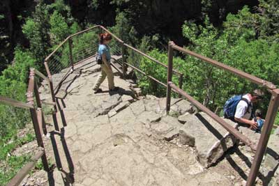
Figure 120—Compliance with the technical requirements on the trail to Hanging Lake at the White River National Forest is not practicable due to the extreme slope of the terrain.
The phrase "is not practicable" in this condition for an exception refers to something that isn't reasonable, rather than to something that is technically impractical. The intent of this condition is that the effort and resources required to comply shouldn't be disproportionately high relative to the level of access established.
Condition for an Exception 2. Where compliance with the technical requirements would fundamentally alter the function or purpose of the facility or the setting.
Public lands provide a wide variety of recreational experiences, from highly developed areas that offer plenty of conveniences and opportunities to relax with family and friends, to wilderness areas that appear unchanged from primeval times and provide opportunities for individuals to experience primitive and challenging conditions. FSTAG recognizes the value of the full range of recreation opportunities by allowing deviations from the technical requirements where compliance would unacceptably change the nature of the recreation opportunities or conflict with the land and the resource management plan for the area.
People using primitive trails, for example, experience the outdoor environment in a nearly natural state, with limited or no development. In these settings, people generally desire challenge and risk so they can use their outdoor skills. Use of manufactured building materials or engineered construction techniques to comply with accessibility provisions could destroy the natural or undeveloped nature of the setting and change the visitor's experience. FSTAG does not require that obstacles be blasted or trails paved to be more accessible if such activity would unacceptably change the character of the setting and the recreation opportunity.
Terminology Tip
What's practicable?
Using heavy construction equipment, it may be possible to provide a trail with a maximum 1:20 (5 percent) grade up a 1,500-foot (460-meter) mountain (figure 121). However, the trail would be about three times as long as under a traditional back-country layout (figure 122). The length of the trail could cause inappropriate environmental and visual impacts and more than triple the amount of ground disturbed. It wouldn't be practicable to construct a trail in compliance with technical accessibility requirements.
Figure 121—A trail with a 5-percent grade on a steep hill.
Figure 122—A traditional trail layout for a steep hill.
Consider a trail intended to provide a rugged experience, such as a cross-country training trail with a steep grade or a fitness challenge course with abrupt and severe changes in elevation. If these trails were flattened out or otherwise constructed to comply with the technical accessibility requirements, they wouldn't provide the desired challenge for users. Trails that traverse boulders and rock outcroppings are another example. The purpose of these trails is to provide users with the opportunity to climb the rocks. To remove the obstacles along the way or reroute the trail around the rocks would destroy the purpose of the trail. The nature of the setting also may be compromised by actions such as widening a trail for an imported surface or removing vegetation from fragile or erosive soils.
Condition for an Exception 3. Where compliance with the technical requirements cannot be accomplished with the prevailing construction practices.
This condition for an exception may apply when the construction methods needed to comply with a technical requirement would require the use of equipment or methods other than those typically used in that setting. For instance, in an area where small equipment is normally used to minimize impact on a sensitive adjacent stream, blasting might be necessary for rock removal to meet the technical width requirement for a trail. Because blasting typically would not be used in this situation, this condition for an exception would apply. If the work could be done using small equipment, this condition for an exception wouldn't apply.
This condition for an exception is not intended to exempt the trail from the technical requirements of FSTAG simply because a trail builder's favorite construction practice (such as the use of a large mechanical roller rather than a smaller vibrating plate or "whacker" type compactor) is inappropriate or impractical. A contractor's or designer's preference for different equipment is not a prevailing construction practices issue. A deviation from a specific technical requirement only can be allowed if the equipment is essential to complete the construction in that location.
Condition for an Exception 4. Where compliance is precluded because the cultural, historic, or significant natural features are protected or are eligible for protection under Federal, State, or local law by:
-
Endangered Species Act (16 U.S.C. 1531 et seq.)
-
National Environmental Policy Act (42 U.S.C. 4321 et seq.)
-
National Historic Preservation Act (16 U.S.C. 470 et seq.)
-
Wilderness Act (16 U.S.C. 1131 et seq.)
-
Other Federal, State, or local law (the purpose of which is to preserve threatened or endangered species; the environment; or archaeological, cultural, historical, or other significant natural features)
Cultural features include archeological sites, burial grounds and cemeteries, traditional cultural properties, tribal protected sites, and other properties considered sacred by an organized religion. Historical features are properties listed or eligible for listing on the National Register of Historic Places or other places of recognized historic value. Significant natural features are objects that are regarded as distinctive or important locally, regionally, or nationally and, therefore, have been placed under legal protection, such as a large boulder or rocky outcrop, body of water, or unique tree or vegetation such as a giant sequoia grove (figure 123). Areas that are legally protected include wilderness areas designated by Congress and areas protected under Federal or State laws, such as habitat for threatened or endangered species or designated wetlands.
Figure 123—The Long Meadow grove of giant sequoias is an example of a significant natural feature.
Situations when this condition for an exception may apply include these examples:
-
Where use of mechanized equipment is prohibited by law, such as in wilderness areas designated by Congress, and work necessary to comply with a technical accessibility provision can't be accomplished using handtools
-
Where imported materials, such as soil stabilizers, are prohibited to maintain the integrity of a natural ecosystem or historic resources
-
Where construction methods and materials are strictly limited to protect designated wetlands or coastal areas
-
Where the physically undisturbed condition of the land is an important part of a sacred observance, such as at tribal sacred sites
-
Where water crossings are restricted to safeguard aquatic features or species protected under Federal or State laws
The Federal laws specified in Condition 4 prescribe certain activities or require certain analyses or procedures to be followed when planning projects that may impact features protected under those laws. This condition for an exception applies when it is determined that the actions, required analyses, or other impacts necessary to meet the technical requirements would directly or indirectly substantially harm the protected feature.
Design Tip
Determine the extent of impact.
Only consider the additional impact of increasing the width, reducing the trail grade or cross slope, or other change required for accessibility. For example, consider a trail project that crosses a hill where a population of wildflowers of an uncommon species is growing. The surrounding river drainage and a nearby town are named for the plants. The trail construction will destroy most of the flowers, as well as the seep-dampened hanging meadow that provides their habitat. Condition 4 wouldn't apply if 323 square feet (30 square meters) would be disturbed to construct a trail that is not accessible and only an additional 75 square feet (7 square meters) would be disturbed to construct a trail that meets the technical accessibility requirements. The majority of the proposed damage to the wildflowers is not attributable to compliance with accessibility requirements. In this case, an alternate location should be selected for the trail.
General Exceptions in FSTAG
Some public lands are reasonably well suited for pedestrian travel. Other public lands are rocky, soggy, excessively steep, or otherwise less well suited to casual foot traffic. Two general exceptions are provided in FSTAG, section 7.2 to ensure that accessibility is provided to the extent appropriate to the setting where it will have the most benefit, be practicable, and provide a meaningful hiking opportunity.
Document the basis for the determination that either of the general exceptions applies to a trail or a portion of a trail and maintain the documentation with the records of the construction or alteration project. In addition, if General Exception 2 applies, send notification to the U.S. Access Board. Documentation and notification requirements are explained in "Documenting Exceptions and Notifying the U.S. Access Board about Exemptions" of this guidebook.
General Exception 1 allows deviations from the technical requirements if a condition for an exception prohibits full compliance. It's not a complete exemption from the provision, because it requires that the technical requirement must still be met to the extent practicable.
For instance, if Condition for an Exception 3 prohibits importing several tons of stabilization material to ensure that the surface of a trail in a nonmotorized area will be firm and stable during the primary season(s) of use under normally occurring weather conditions, you must still make sure the surface is as firm and stable as is practicable. For instance, if relocating a section of trail a few feet laterally will achieve firmness and stability with native soils during the dry portion of the season or even during part of the wetter season, you must relocate that section. Such measures are practicable and should be utilized. General Exception 1 only applies to the portion of the trail where the condition for an exception exists. On all other sections of the trail, ensure that technical requirements are met. All of the unaffected technical requirements must be met for the full length of the trail, including the section where the condition for an exception prohibits full compliance with the particular technical requirement. Practicable means reasonable rather than technically possible. (See TERMINOLOGY TIP—What's practicable?, page 32.)
Another example of the use of General Exception 1 is when construction of a trail appears to fall under Condition for an Exception 4, where compliance is not possible because the cultural, historic, or significant natural features are protected or are eligible for protection under Federal, State, or local law. For instance, consider a situation where a trail is needed between a stream with endangered aquatic species and a cliff with petroglyphs on it and you can't get the required trail width without either filling part of the stream or destroying some petroglyphs. A narrower trail would be allowed past the petroglyphs. However, the other technical requirements still apply to that stretch of trail and the technical requirement for width still applies to all the rest of the trail.
Design Tip
Compliance is required on both sides of a deviation from the technical requirements.
Although accessible design is based on wheelchair dimensions, clear space, maneuvering room, and reach ranges, only 4 percent of people with disabilities use wheelchairs. The majority of people who have mobility limitations don't use a wheelchair. They either use no assistive devices or rely on crutches, canes, walkers, or braces. They may be able to get around or over an obstacle without too much difficulty. Although steep terrain may be difficult, it may be manageable for limited distances.
Likewise, a person using a wheelchair might need assistance to make it up a steep grade (figure 124) or to get over an obstacle, but after that challenge, the individual can continue on the trail independently if the rest of the trail complies with the accessibility guidelines.
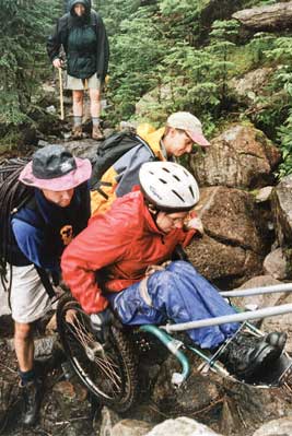
Figure 124—Members of the Northeast Passage hiking team assist their teammate up a steep part of the Galehead Trail. She only needs assistance for a short distance. Photo credit: Northeast Passage, Durham, NH
General Exception 2 addresses extreme environmental barriers that are effectively impassable and trails with numerous environmental barriers that can't be eliminated. These barriers can make the rest of the trail unreachable for many people with mobility limitations. General Exception 2 may be considered only after applying General Exception 1 so that the trail sections where full compliance with the technical requirements can't be achieved are identified. Then evaluate the entire trail comparing the trail sections that can and can't meet the full technical requirements to determine whether it would be impracticable for the entire trail to comply with the accessibility requirements.
The following condition criteria have been accepted by the U.S. Access Board for identifying when extreme environmental barriers may exempt an entire trail from technical accessibility requirements:
-
A combination of running slope and cross slope exceeds 1:2.5 (40 percent) for more than 20 feet (6 meters) (figure 125).
-
An obstacle 30 inches (760 millimeters) high or more crosses the full tread width of the trail (figure 126).
-
The surface of the trail is neither firm nor stable for a distance of 45 feet (14 meters) or more.
-
The tread width of the trail is 12 inches (305 millimeters) or less for a distance of 20 feet (6 meters) or more.
-
15 percent or more of the trail does not fully comply with the technical requirements.
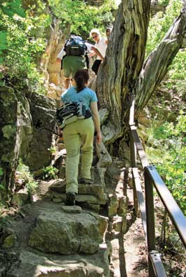
Figure 125—The combination of running slope and cross slope on the trail to Hanging Lake is so severe for such an extended distance that the entire trail was exempted from the technical requirements.
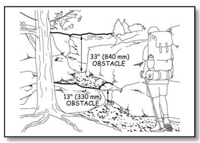
Figure 126—The 33-inch (840-millimeter) rock face is an example of an extreme environmental barrier.
Some long-distance trails, such as the Continental Divide, Pacific Crest, Appalachian, and Florida National Scenic Trails and the Nee-Me-Poo National Historic Trail, span many districts or forests. For these trails, only the length of trail planned for construction or alteration within the current planning period is considered when figuring the 15 percent, not the entire length of the trail. This principle applies even if the planning period is several years long. Consider connected sections of trail that will be constructed or altered over several years, together. Do not consider unconnected segments of trail that are covered by the same planning process together, unless there is a special circumstance where several segments function together to access one attraction or serve one purpose.
Short Hikes and Interesting Features
Sometimes it makes sense to provide a short section of trail meeting the technical requirements for accessibility on a trail that would otherwise be totally exempted from the technical requirements under General Exception 2. Even if visitors can't hike the entire trail, a short hike may be enjoyable (figure 127). If there are no uncorrectable environmental barriers and few or no significant conditions requiring exceptions between the trailhead and the first extreme environmental barrier, and that trail segment is at least 500 feet (152 meters) long, consider constructing that section of trail to meet the technical requirements even though the rest of the trail is not accessible.
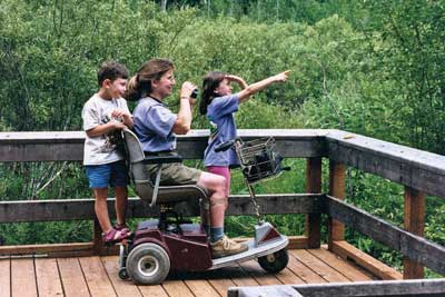
A short section of trail is especially enjoyable if an interesting natural, cultural, or historic feature is located between the trailhead and the first extreme environmental barrier. The feature might be the focal point, main attraction, or destination of the trail or it may simply be an interesting secondary feature, such as a boulder outcrop, a waterfall, a grouping of old or unique trees, a cultural or historic structure, a wildflower meadow, an area popular for wildlife viewing, or a vista. In such cases, hikers would appreciate you constructing the section of the trail leading to the prominent feature in compliance with the technical accessibility requirements.
Here's an example of how the guidance on General Exception 2 can be used. Consider the design for a new 1-mile (1,600-meter) -long trail with a waterfall (an interesting feature) about 300 feet (91 meters) from the trailhead. Fifteen percent of 1 mile (1,600 meters) is 792 feet (240 meters). Add together all the lengths of trail where technical requirements can't be met because of conditions for an exception. If the total length is more than 792 feet (240 meters), the trail would be eligible for a total exemption from the technical requirements of FSTAG. However, if there are no uncorrectable environmental barriers and few or no significant conditions requiring exceptions between the trailhead and the waterfall, that section of trail should, in most cases, comply with the technical requirements even though the rest of the trail does not.
Documenting Exceptions and Notifying the U.S. Access Board About Exemptions
U.S. Access Board About Exemptions When a condition for an exception prohibits full compliance with a specific technical requirement on a section of trail as allowed in General Exception 1, document the reason that full compliance wasn't achieved and file it with the project records for the trail construction or alteration project. Include which condition for an exception applies to the trail or segment of trail, the reason that it applies, the date the decision that the exception applies was made, and the names of the individuals who made the decision.
Infrequently, extreme or numerous conditions for exemptions make it impracticable to provide a route that meets the requirements, so General Exception 2 allows exempting the entire trail from the technical requirements. In these cases, document the explanation of the conditions that make it impracticable for the entire trail to comply. Retain the documentation with the records for that construction or alteration project. Notify the U.S. Access Board of the determination to exempt the entire trail. Contact information for the U.S. Access Board is available at http://www.access-board.gov/. The U.S. Access Board has drafted a form that may be used to document and submit an exemption decision. The form will be available at http://www.access-board.gov/guidelines-and-standards/recreation-facilities/outdoor-developed-areas when the U.S. Access Board final guidelines are published.
Technical Requirements for Accessible Hiker/Pedestrian Trails
Section 7.4 of FSTAG explains the accessibility requirements for trails, including trail surfacing, clear tread width, grade and cross slope, resting intervals, passing spaces, tread obstacles, protruding objects, openings, and signs. All of these requirements are minimums. In the spirit and intent of universal design, designers are encouraged to meet the highest standards wherever it is practicable, given the specific natural constraints of the environment, the level of development, and other managerial considerations. Trail puncheons and trail bridges are included in the Forest Service definition of trail structures, so they must be constructed to meet the same requirements as the rest of the trail tread. In the following text, the word "trail" includes trail puncheons and trail bridges.
Wheelchair dimensions, clear space, maneuvering room, and reach ranges found in Architectural Barriers Act Accessibility Standards (ABAAS) are the basis for trail designs that maximize accessibility and are appropriate to the setting. The dimensions, multiple moving surface contact points, and wheels of a wheelchair are usually the most difficult to accommodate. If a person who uses a wheelchair can use a trail, a majority of other people can, too.
The rest of this part of the guidebook explains the technical accessibility requirements for trails and provides an overview of the FSTAG implementation process and a flowchart of the FSTAG implementation process. The flowchart is designed to be used while laying out the flag line for a trail.
Surfaces of Trails
Trail surfaces must be firm and stable. The first general exception allows achieving firmness and stability to the extent practicable if a condition for an exception prohibits full compliance with surface requirements.
Paving with concrete or asphalt is appropriate for highly developed areas. For less developed settings, crushed gravel, fine crusher rejects, packed soil, and other natural materials may provide a firm and stable surface (figure 128). Natural materials also can be combined with synthetic bonding materials that provide stability and firmness. These materials may not be suitable for every trail, which is why the deviation due to the presence of a condition for an exception is permitted.
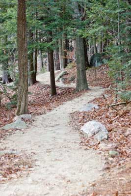
Figure 128—Natural materials were used to build a firm and stable surface for the Crotched Mountain Trail in New Hampshire.
Slip resistance is not required for trails. Tree and shrub leaves and needles, dirt, ice, snow, other surface debris, and weather conditions are part of the natural environment and would be difficult, if not impossible, to avoid.
FSTAG defines a firm surface as one that resists deformations by indentations. (See DESIGN TIP—Use a rule of thumb to estimate firmness and stability., page 37.) Natural soils should be evaluated for their ability to be compacted into a firm and stable surface under normally occurring weather conditions during the primary season of use. When evaluating surface material suitability, keep in mind that FSTAG defines a stable surface as a trail surface that is not permanently affected by normal weather conditions and that is able to sustain wear and tear produced by normal use between planned maintenance cycles. Local trail managers are a good source of information because they know the local surfaces and how they wear throughout the primary seasons for which the trail is managed.
Clear Tread Width of Trails
Clear tread width is the width of traveled surface between obstacles on the ground and above the ground (figure 129). Provide at least 36 inches (915 millimeters) of clear tread width. An exception permits the width to be reduced to 32 inches (815 millimeters) minimum if a condition for an exception prevents the wider tread. If even the reduced width of 32 inches can't be met due a condition for an exception, the first general exception allows achieving the width requirement to the extent practicable.
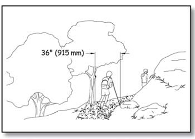
Figure 129—The requirements for clear tread width on a trail.
Trail Slopes
Trail slopes must meet the requirements that follow. Steeper terrain makes it difficult to achieve flat grades everywhere. Many people are able to handle steeper slopes for short distances. Short sections of steeper trail are allowed so that trails can be constructed in varying terrain. The first general exception allows achieving trail slopes to the extent practicable if a condition for an exception prohibits full compliance with slope requirements
Running slope is the lengthwise slope of a trail, parallel to the direction of travel. In this guidebook, the terms running slope and grade often are used interchangeably. Trails or trail segments of any length may be constructed with a running slope ratio of up to 1:20 (a 5-percent grade). To accommodate steep terrain, trails may be designed with shorter segments that have a running slope (grade) and length as shown in table 5.
Table 5—Trail running slope and segment length.
| Running Slope of Trail Segments | Maximum Length of Segment Between Resting Intervals | |
|---|---|---|
| Steeper than | But no Steeper than | |
| 1:20 (5 percent) ) | 1:12 (8.33 percent) | 200 feet (61 meters |
| 1:12 (8.33 percent) | 1:10 (10 percent) | 30 feet (9 meters) |
| 1:10 (10 percent) | 1:8 (12 percent) | 10 feet (3.05 meters) |
Provide a resting interval between each of these steeper slope segments. To ensure that the trail is not designed as a series of steep segments, do not exceed a grade of 1:12 (8.33 percent) for more than 30 percent of the total length of the trail. The running slope (grade) must never exceed 1:8 (12 percent).
Construction Tip
Slope and grade terminology.
Slopes are often described as a ratio of vertical distance to horizontal distance, or rise to run (figure 130). For instance, a slope ratio of 1:20 means that for every foot of vertical rise, there are 20 feet of horizontal distance (or for every meter of vertical rise, there are 20 meters of horizontal distance).
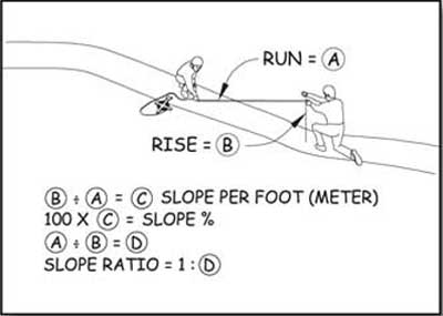
Figure 130—Determining the slope ratio.
Cross slopes—the side-to-side slope of a trail tread (figure 131)—provide drainage to keep water from ponding and damaging the trail, especially on unpaved surfaces. Cross slopes that are too steep can be difficult to traverse, but trails with too little cross slope tend to become streams. Water running down or ponding on trails destroys them. Cross slopes are an important part of trail design and construction.
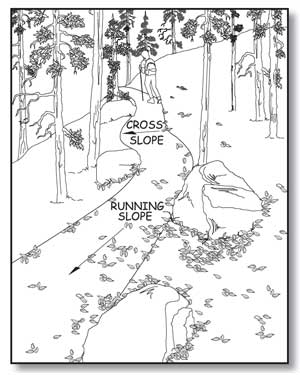
Figure 131—The running slope is measured along a trail's length; the cross slope is measured across its width.
Ensure that cross slopes do not exceed 1:20 (5 percent). If the trail surface is paved or built with boards, however, do not allow the cross slope to be steeper than 1:48 (2 percent).
Resting Intervals on Trails
Resting intervals are relatively level areas that provide an opportunity for people to stop and catch their breath. Provide resting intervals between each trail segment any time the running slope exceeds 1:20 (5 percent) as shown in table 5. Ensure that the resting interval is at least 60 inches (1,525 millimeters) long and at least as wide as the widest segment of the trail tread leading into it, if the resting interval is within the trail (figure 132). If the resting interval is beside the trail, ensure that it is at least 60 inches (1,525 millimeters) long and at least 36 inches (915 millimeters) wide. If the resting interval is adjacent to the trail tread, provide a turning space complying with ABAAS section 304.3.2. This doesn't mean that another space must be provided for turning around or as a passing space in addition to the resting space. The resting space itself may also serve as the turning and passing space if it is at least 60 inches (1,525 millimeters) in diameter or is T-shaped with a minimum 60- by 36-inch (1,525-by 915-millimeter) arm and a minimum 36-inch (915-millimeter) -wide by 24-inch (610-millimeter) -long base (figure 133).
Design Tip
The cross slope requirement depends on what material is used.
Those who use a manually operated wheelchair or a walker know that as cross slope increases, travel becomes more difficult. This is because working against the sideways pull of the cross slope can double the effort needed to make forward progress. However, in an outdoor environment, the cross slope has to be steep enough that water won’t accumulate on the travel surface. While slope and drainage can be precisely controlled on surfaces that are paved (asphalt, concrete, paving blocks, and so forth) or built with boards (wood planks, heavy timber, concrete, fiberglass, or other manufactured material), it’s more difficult to ensure drainage on natural or gravel surfaces. When water accumulates on natural or gravel surfaces, they often become muddy and impassible. That’s why the cross slope is allowed to be steeper on natural or gravel surfaces than on surfaces that are paved or built with boards.
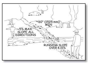
Figure 132—The requirements for resting intervals.
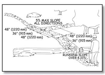
Figure 133—The requirements for a resting interval at a T-intersection.
The slopes of a resting interval must not exceed 1:20 (5 percent) in any direction. However, when the surface is paved or is built with boards, the slope is not allowed to be steeper than 1:48 (2 percent) in any direction. No significant difference in vertical alignment between the trail tread, turning space, and resting interval is allowed where they meet. The first general exception allows achieving resting interval requirements to the extent practicable if a condition for an exception prohibits full compliance with the requirements.
Passing Spaces on Trails
A 60-inch (1,525-millimeter) clear tread width is required for two wheelchairs to pass safely and comfortably on a trail. However, this width is not always appropriate in all settings and for all trail classes. Where the clear tread width of a trail is less than 60 inches (1,525 millimeters), provide passing spaces at least every 1,000 feet (300 meters) and at the end of any segment of trail that meets the technical requirements, if the full length of the trail does not. Passing spaces must be at least 60 inches (1,525 millimeters) wide (including the trail width) by 60 inches (1,525 millimeters) long (figure 134). A T-intersection of two trails or other walking surfaces also may be used as a passing space if the arms and stem of the T-shaped space extend at least 48 inches (1,220 millimeters) beyond the intersection (figure 135). Either configuration would provide enough room for someone to move to the side. If a condition for an exception prevents achieving full compliance with the passing space requirements, the first general exception allows achieving passing space requirements to the extent practicable.
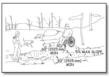
Figure 134—The requirements for passing spaces.
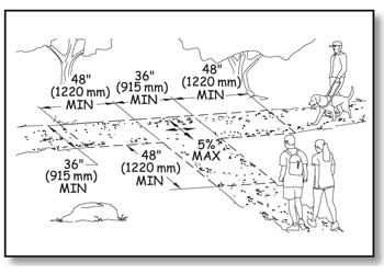
Figure 135—The requirements for passing spaces at T-intersections.
Tread Obstacles on Trails
A tread obstacle is anything that interrupts the evenness of the tread surface. On trails, tread obstacles often occur as a result of ruts, roots, and rocks in the tread surface. Ensure tread obstacles are not more than 2 inches (50 millimeters) high. Where the surface is paved or is built with boards, ensure tread obstacles do not exceed one-half inch (13 millimeters) in height. Height of tread obstacles must be measured vertically from the trail tread surface to the highest point of the obstacle. If a condition for an exception prevents achieving full compliance with the obstacle height requirements, the first general exception allows achieving the requirements to the extent practicable.
Protruding Objects and Trails
Objects that extend into the travel way of a trail from the side or from overhead can be hazardous to people who are paying more attention to their companions than the travel route (figure 136), as well as to people who are blind or have low vision. Protruding objects are defined as constructed features such as signs that extend into the clear width area of a trail, resting interval, or passing space between 27 inches (685 millimeters) and 80 inches (2,030 millimeters) above the travel surface. Do not allow protruding objects to extend into the clear width area more than 4 inches (100 millimeters).
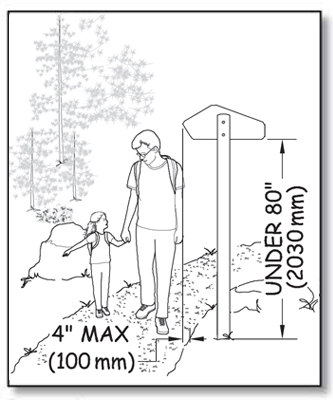
Figure 136—Constructed objects must not extend over the trail more than 4 inches (100 millimeters) if they are between 27 inches (685 millimeters) and 80 inches (2,030 millimeters) above the travel surface.
Accessibility guidelines do not consider natural elements such as tree branches and rock formations to be protruding objects. However, you should follow the specific Trail Management Objectives for each trail that address protrusions, obstacles, and clearing widths and heights. For instance, trails should generally not be routed too close to rock overhangs. Clearing limits for trail construction and maintenance usually require that brush, limbs, trees, and logs be cut back a foot or more from the edge of the trail. However, the trail maintenance cycle may be several years for some trails, and vegetation may encroach on the trail during the interim. The protruding object requirement recognizes that it may not always be practicable to control vegetation, but it is always practicable to place constructed features where they won't interfere with hikers. It also recognizes situations where rock ledges are unavoidable or where trails pass through caves (figure 137).
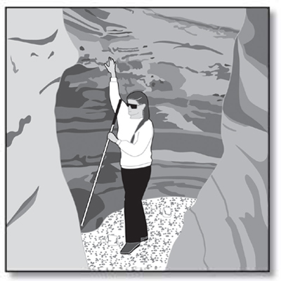
Figure 137—Protruding object requirements do not apply to natural features, such as caves in undeveloped areas.
Openings in Trail Surfaces
Openings are gaps in the surface of a trail. Gaps include slots in a drainage grate and spaces between the planks on a puncheon, bridge, or boardwalk. Openings that are big enough to allow wheels, cane or crutch tips, or shoe heels to drop through or get stuck are hazards that shouldn't exist in pedestrian routes. Openings up to a half of an inch (13 millimeters) across are permitted in trail surfaces. Place elongated openings more than a quarter of an inch wide with the long dimension perpendicular or diagonal to the primary direction of travel (figure 138).
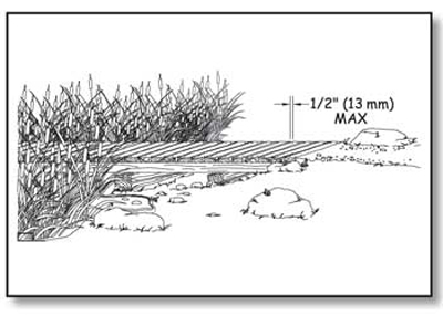
Figure 138—The requirements for openings that are perpendicular to the direction of travel on trail surfaces, such as boardwalk decking.
If there is a condition for an exception, openings less than three-fourths of an inch (19 millimeters) across are allowed. This deviation allows the use of boardwalk decking that needs more than ½-inch (13-millimeter) -wide spacing between the planks to permit expansion and to allow water to drain. If even the three-fourths of an inch deviation is not enough, General Exception 1 allows achieving trail surface opening requirements to the extent practicable if a condition for an exception is present.
Trail Facilities
To comply with the Architectural Barriers Act of 1968 (ABA) and Section 504 of the Rehabilitation Act of 1973, trail facilities such as tent pads and platforms, camp shelters, pit toilets, viewing areas, and similar structures for trail users that are provided along trails—even trails that are not accessible— must be designed to comply with the applicable provisions in FSORAG, except that slopes not steeper than 1:20 (5 percent) are allowed if necessary for drainage of unpaved surfaces that aren’t elevated above the natural ground.
The path of travel between trail facilities, as well as the path connecting them to a trail, must comply with FSTAG. These paths are not outdoor recreation access routes and are not required to meet the technical requirements for an outdoor recreation access route.
Trail facilities must be designed appropriately for the setting and in compliance with the applicable provisions in FSORAG to ensure that the facility can be used for its primary purpose by all hikers, including hikers with disabilities. For example, if a camp shelter is provided along a trail and its floor is above the ground, all hikers must be able to get inside the shelter. As explained in "Camp Shelters" of this guidebook, this can be accomplished by ensuring the camp shelter floor is 17 inches (430 millimeters) minimum to 19 inches (485 millimeters) maximum higher than the camp shelter space at the shelter entrance. This height allows someone using a wheelchair or other assistive device to transfer onto the floor of the shelter.
Requirements for all recreation facilities, including those that are commonly associated with trails, are contained in FSORAG and explained in "Applying the Forest Service Outdoor Recreation Accessibility Guidelines" of this guidebook.
Gates and Barriers on Trails
If gates or barriers are constructed to control access to trails, include openings wide enough to allow hiker passage. Refer to the FSTAG for the technical provisions for gates and barriers. These requirements are also explained in "Getting From Here to There—Outdoor Recreation Access Routes" of this guidebook.
Trailheads
To comply with the ABA and Section 504 of the Rehabilitation Act of 1973, ensure that each constructed feature provided at a trailhead complies with the applicable provisions of FSORAG and ABAAS. Requirements for trailhead features, such as parking spaces, toilets, water spouts, and campsites, are explained in "Applying the Forest Service Outdoor Recreation Accessibility Guidelines" of this guidebook.
Because trailheads are usually accessed by vehicle rather than only by hiking, at least one outdoor recreation access route must connect the following places at trailheads:
-
Accessible parking spaces or other arrival point
-
Starting point of the trail
-
Accessible outdoor constructed features, elements, spaces, and facilities within the trailhead
In alterations to existing trailheads, where there is a condition for an exception, the technical requirements for the outdoor recreation access route that are affected by the condition for an exception must be achieved only to the extent practicable. If elements, spaces, or outdoor constructed features are altered at trailheads but the path of travel isn't changed, an outdoor recreation access route isn't required.
Design Tip
New trail facilities must be accessible even if the trail doesn't comply with Forest Service Trail Accessibility Guidelines.
The Architectural Barriers Act of 1968 (ABA) requires that buildings comply with the applicable accessibility guidelines. This issue was clarified for Federal agencies when a complaint was filed with the U.S. Access Board against the U.S. Department of the Interior, National Park Service for installing an inaccessible toilet at 10,000 feet (3,048 meters) on Mt. Rainer. The petitioner was a paraplegic who was climbing the mountain with a sit-ski and ropes. He was not able to use the toilet that the rest of his party could use because it wasn't accessible. The U.S. Access Board found that the National Park Service was not in compliance with ABA that requires all new construction funded by Federal Executive agencies to be accessible. The National Park Service settled the complaint by replacing the toilet with an accessible model.
The Forest Service was cited by the U.S. Access Board after a complaint was filed about a pit toilet serving the trail at North Doublehead in New Hampshire. The toilet was constructed in 1972 after the 1968 passage of the ABA, but the toilet was not accessible. The Forest Service replaced the toilet with an accessible model.
It's really in the best interests of all organizations to ensure that all facilities—regardless of where they are located—are appropriate to the setting and are accessible. When accessibility is integrated into the design from the beginning, there's not much difference in cost. If the design of a facility that's already under construction must be changed to provide for accessibility, or if an inaccessible facility has to be replaced with an accessible facility at a later date, costs will be substantial.
To quote a hiker with a Northeast Passage hiking team that includes a diverse group of people (figure 139): "Hiking a trail is a challenge by choice; using a toilet is not a choice so it shouldn't be a challenge."
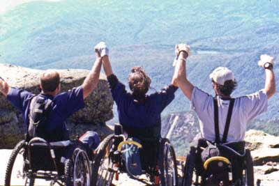
Figure 139—Three members of the Northeast Passage hiking team celebrate their conquest of Mount Lafayette in New Hampshire. Photo credit: Northeast Passage, Durham, NH
Trailhead Signs
People have made it clear that they want information about trails, including length, grade, and so forth, so that they can make their own decisions about which trail is appropriate for the amount of time they have available, the people in their group, and the type of hike they are interested in pursuing. Therefore, when new information signs are provided at trailheads for newly constructed or altered trails, include at minimum the following information:
-
Trail name
-
Length of the trail
-
Type of surface on the trail
-
Typical and minimum trail tread width
-
Typical and maximum trail grade
-
Typical and maximum trail cross slope
-
Height of any major obstacles, such as boulders, in the trail tread
-
A statement that posted information reflects the condition of the trail when it was constructed or assessed, including the construction or assessment date
The requirement for posting the construction and trail assessment date is because tree blowdowns, flooding, or other events can make trails designed and constructed to FSTAG standards temporarily inaccessible until maintenance crews can clear the obstruction. If the date is posted, people will be able to evaluate the likelihood that the trail remains in the posted condition. For instance, people may know that a major storm has occurred since the conditions were posted or may estimate the likelihood that vegetation may have overgrown the trail since the condition was evaluated.
Where more extensive trail information such as an aerial map of the trail and related facilities is provided, identify the location of specific trail features and obstacles that do not comply with FSTAG's technical requirements and include a profile of the trail grade.
If materials, such as maps, brochures, fee envelopes, and so forth, need to be obtained from or filled out at a sign or kiosk, design the sign or kiosk to display the materials within the standard reach ranges of a person in a wheelchair in accordance with ABAAS, section 308, as explained in "Reach Ranges and Operability Requirements" of this guidebook.
Locate trailhead information signs centered at the back of a 30- by 48-inch (760- by 1,220-millimeter) -minimum clear floor or ground space. Do not allow the clear space to overlap the trail width but it may overlap a resting space or passing space. The slope of the clear space is not allowed to be more than 1:20 (5 percent) in any direction.
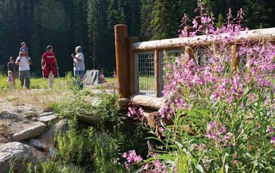
Overview of FSTAG Implementation Process
Now that you have learned about the extent of application, general exceptions, and the technical requirements, you may wonder how the whole process ties together. Use the following four easy steps and the handy process flowchart in the appendix to implement FSTAG on your trail design projects. Following this process will help you verify that the trail design complies with the technical requirements to the extent practicable, help you document how and where the technical requirements can, or cannot, be applied, and confirm that the character, trail class, and experience of the setting will not be changed. It also can be used as a field guide when locating or rerouting a trail.
Step 1: Determine the Applicability of FSTAG
After a decision has been made to design or alter a trail, three questions must be asked:
1. Does the work meet the definitions for new construction or alteration? Definitions are in "Understanding Trail Terminology" of this guidebook.
-
If yes,
2. Is the Designed Use "Hiker/Pedestrian"?
-
If yes,
3. Does the proposed trail connect to a trailhead or to a trail that substantially complies with FSTAG? (Trailhead is defined in "Understanding Trail Terminology.")
If the answer to any of these questions is no, FSTAG does not apply and no further analysis is required. The finding and reasons that FSTAG does not apply should be briefly documented and put in the project file. Figure 140 shows step 1. Even if compliance with FSTAG is not required, you should try to incorporate accessibility where opportunities exist and to the extent you can without changing the character of the setting and, therefore, the hiking experience.
If the answer to all three questions is yes, the designer moves to step 2.
Figure 140—Step 1 of the Forest Service Trail Accessibility Guidelines implementation process. (For a larger image please click here.)
Design Tip
Evaluate your trail design for Forest Service Trail Accessibility Guidelines (FSTAG) compliance using on-the-ground layout.
In order to work through steps 2, 3, and 4 of the implementation process, lay out a proposed trail alignment on the ground and conduct the evaluation as you walk the flag line. Base the review and analysis required in these steps on actual field conditions, rather than relying only on topographic maps.
Step 2: Identify the Presence of Limiting Factors
This step addresses the condition criteria accepted by the U.S. Access Board for identifying when extreme environmental barriers allow the use of General Exception 2. These barriers are defined in the first four limiting factors in FSTAG, section 7.2.2.1 "Determining Impracticability" and are explained in "General Exceptions in FSTAG" of this guidebook. The sequence for identifying the limiting factors may vary and does not need to be done in the order illustrated in the process flowchart.
Work your way through the process flowchart by asking four questions, each related to one of the limiting factors. The first question will be explained in detail to serve as an example for the other three.
Does the combined trail running slope (grade) and cross slope exceed 1:2.5 (40 percent) for a continuous distance of 20 feet (6 meters) or more?
Construction Tip
Choose a method to measure the running slope.
There are a number of ways you can measure running slope. You can perform an informal survey between obvious trail slope breaks with a hand level, survey rod, and measuring chain (figure 141). You can use a digital level (figure 142). You can also perform a more detailed trail assessment such as the universal trail assessment process developed by Beneficial Designs (http://www.beneficialdesigns.com/).
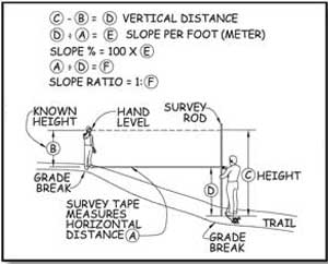
Figure 141—Surveying trail grade with a hand level.
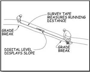
Figure 142—Surveying trail grade with a digital level.
If not, FSTAG may still apply, so you should consider Design Tip the next limiting factor. A continuous distance means a sustained running slope (grade) without rest areas or more moderate slopes. If the alignment can be relocated to get a more moderate slope, this limiting factor doesn't apply.
If the combined slope exceeds 1:2.5 (40 percent) for a continuous distance of 20 feet (6 meters) or more, document the length of trail that exceeds the technical requirements for slopes, the location of the area, and your data source (field survey, clinometer, and so forth). Keep this information for use in step 4.
Next, determine whether a condition for an exception exists that permits a deviation from the technical requirements for slope. If there is no condition for an exception, FSTAG may still apply, so you should proceed to the next limiting factor.
If a condition for an exception does exist, document the length of trail affected by the condition for an exception, what exception applies, and the location of the area.
Next, consider whether the combined trail running slope (grade) and cross slope is so excessive that it is impracticable for the entire trail to comply with the technical requirements. If so, FSTAG does not apply to this trail at all and no further review or analysis is required. Document the reason for the determination, retain it in the project file, and notify the U.S. Access Board, as explained in "Documenting Exceptions and Notifying the U.S. Access Board About Exemptions" of this guidebook.
Finally, consider the end section of trail between the limiting factor and the trailhead or another trail that substantially complies with FSTAG. Is there a prominent feature between the end of the trail and the limiting factor? If so, consider constructing the section of trail between the end of the trail and the prominent feature in compliance with the technical accessibility requirements. Doing so is not required, but it is often good management and good customer service.
Design Tip
Use a rule of thumb to estimate firmness and stability.
What sort of surface is firm and stable? If the answer to both of the following questions is yes, the surface is probably firm and stable.
-
Could a person ride a narrow-tired bicycle across the surface easily without making imprints? (Bicycle tires are similar to the large rear wheels of a wheelchair.)
-
Could a folding stroller with small, narrow plastic wheels containing a 3-year-old be pushed easily across the surface without making imprints? (The stroller's wheels are similar to the front wheels of a wheelchair.)
While this method for determining firmness and stability isn't scientifically accurate, it has proven to be effective.
Work your way through the other three limiting factors the same way. The design tips may help you.
Is the surface neither firm nor stable for 45 feet (14 meters) or more?
Is the trail tread width 12 inches (227 millimeters) or less for a distance of at least 20 feet (6 meters)?
Is there an obstacle at least 30 inches (760 millimeters) high extending across the full width of the trail?
Design Tip
Determine when trail width is a limiting factor.
Measuring the existing trail width is easy—just use a measuring tape to get the side-to-side distance of the narrowest stretch of trail. Figuring out whether that width can be changed may be a little more difficult. The trail may be less than 12 inches (227 millimeters) wide, but if you can widen it in its current location or move the trail alignment to an area where it can be wider, the limiting factor doesn't apply.
If you find a limiting factor where a condition for an exception applies, there's no reason to evaluate the trail beyond that point for successive limiting factors unless the rest of the trail connects to a trailhead or a trail that substantially complies with FSTAG. Just look at the section of trail between the limiting factor or prominent feature and the trailhead or connecting trail. Figure 143 shows step 2.
If there are no limiting factors that would prevent compliance with FSTAG, proceed to step 3.
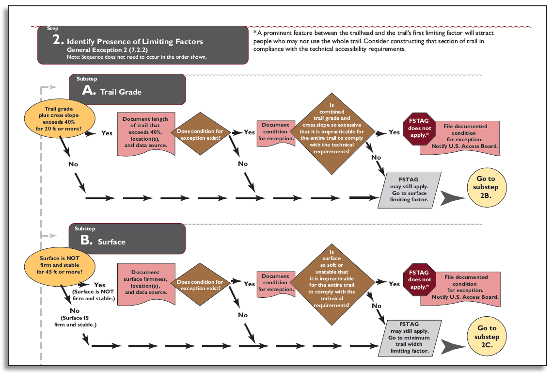
Figure 143—Step 2 of the Forest Service Trail Accessibility Guidelines implementation process. (For a larger image please click here.)
Step 3: Apply the Accessibility Provisions
This step involves looking at FSTAG, sections 7.4.1 through 7.4.8, which contain the technical requirements for trail grade, cross slope, resting interval, surface, clear tread width, passing space, tread obstacles, protruding objects, and openings.
This summary and the process flowchart don't contain everything you need to know about trail design requirements. Refer to FSTAG for detailed instructions, definitions, conditions for an exception, accessibility provisions, and allowable deviations.
A series of questions with yes or no answers is asked for each of the technical requirements, similar to step 2. Use the trail running slope (grade) as an example.
First, look at the existing conditions on the ground and determine whether the trail alignment complies with the required running slopes of a maximum of 1:20 (5 percent) for any distance, 1:12 (8.33 percent) for up to 200 feet (61 meters), 1:10 (10 percent) for up to 30 feet (9 meters), and so forth. Could a change in trail alignment facilitate meeting the requirement? If not, does one of the conditions for an exception prevent compliance? If the trail alignment complies with the required slope or there is no condition for an exception, compliance with the technical requirement for trail grade is required. If the grade requirement can't be met because of a condition for an exception, measure and record the length of trail that will deviate from the technical requirement. Then consider how the running slope could be adjusted to get as close as practicable to the requirement. Record what the slope will be on that section of the trail and proceed to the next technical requirement.
Each technical requirement is addressed in a similar manner. Make a determination for every technical requirement: either compliance is required or deviations are permitted. Be sure to measure and record the length of the trail on which each deviation from a particular technical requirement will occur. Figure 144 shows step 3. After you work through all the technical requirements, proceed to the last step.
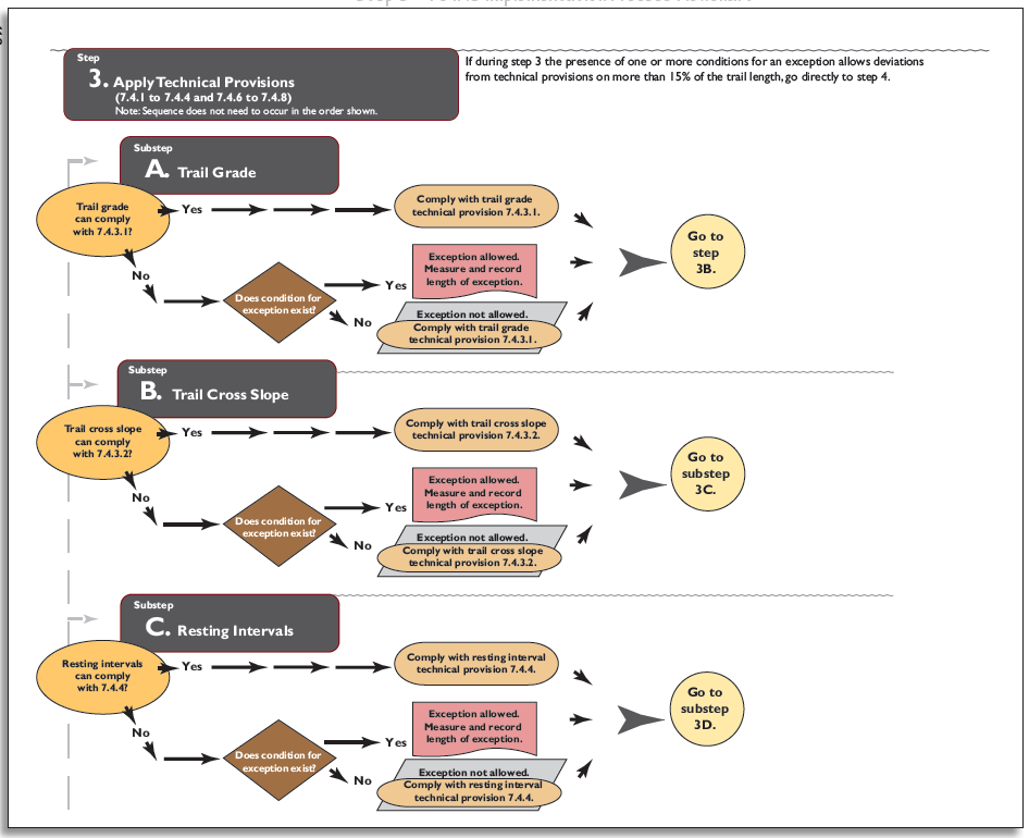
Figure 144—Step 3 of the Forest Service Trail Accessibility Guidelines implementation process. (For a larger image please click here.)
If at any point during step 3 you find that the recorded length of the trail that contains deviations adds up to 15 percent or more of the total trail length, proceed directly to step 4.
Step 4: Calculate Cumulative Deviation Percentage
This final step addresses the suggested objective criteria for identifying when extreme or numerous environmental barriers allow the use of General Exception 2. These barriers are defined in the five limiting factors in FSTAG, section 7.2.2.1.
Design Tip
Apply the process.
Figure 145 helps illustrate how to apply the process by calculating cumulative deviations and considering a prominent feature. The drawing shows that:
-
Deviations occur on more than 15 percent of the trail because 15 percent of 950 feet equals 142.5 feet (15 percent of 290 meters equals 43.5 meters), but the deviations total 216 feet (66 meters).
-
The trail does not have to comply with the guidelines.
-
The first point of deviation occurs 400 feet (122 meters) from the trailhead and the vista is only 250 feet (76 meters) from the trailhead. It may be appropriate to construct the trail in compliance with the guidelines from the trailhead to the vista.
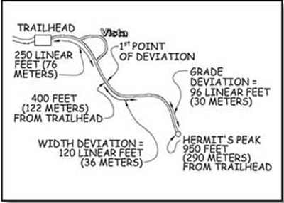
Figure 145—This trail schematic illustrates how to determine where the trail must comply with Forest Service Trail Accessibility Guidelines.
Add the measurements of permitted deviations from step 3. If these deviations occur on 15 percent or more of the total trail length, FSTAG doesn't apply to the trail. Figure 146 shows step 4.
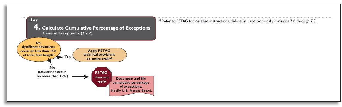
Figure 146—Step 4 of the Forest Service Trail Accessibility Guidelines implementation process. (For a larger image please click here.)
The FSTAG Implementation Process Flowchart
FSTAG must be applied before initiating new construction or altering any National Forest System trail with a "Designed Use" of "Hiker/Pedestrian." Figure 147 distills the implementation process into a quick reference that provides easy reference as you work through the process. A detailed FSTAG implementation process flowchart is available in the appendix.
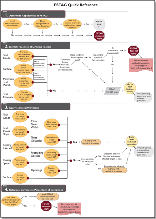
Figure 147—Quick reference for the Forest Service Trail Accessibility Guidelines implementation process. (For a larger image please click here.)
Before applying FSTAG, you'll need to:
-
Analyze existing conditions, including potential opportunities and constraints (National Environmental Policy Act analysis).
-
Identify and verify the desired Trail Class for the trail or trail segment.
-
Identify and verify the "Designed Use" of the trail or trail segment.
If you have questions about applying any of the above information, please contact your region's recreation accessibility coordinator. Current contact information is available at http://www.fs.fed.us/eng/toolbox/acc/documents/coord.htm#leader.
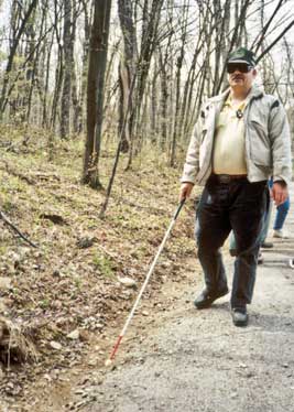
Acronyms
ABA—Architectural Barriers Act
ABAAS—Architectural Barriers Act Accessibility Standards
Access Board—Architectural and Transportation Barriers Compliance Board
ADA—Americans with Disabilities Act
ADASAD—Americans with Disabilities Act Standards for Accessible Design
ANSI—American National Standards Institute
ATV—All-terrain vehicle
BEIG—Built Environment Image Guide
CFR—Code of Federal Regulations
DOD—U.S. Department of Defense
FHWA—U.S. Department of Transportation, Federal Highway Administration
FSORAG—Forest Service Outdoor Recreation Accessibility Guidelines
FSTAG—Forest Service Trail Accessibility Guidelines
GSA—U.S. General Services Administration
HUD—U.S. Department of Housing and Urban Development
IBC—International Building Code
ISA—International Symbol of Accessibility
FTDS— Federal Trail Data Standards
MUTCD—Manual of Uniform Traffic Control Devices
OHV—Off-highway vehicle
ORAR—Outdoor Recreation Access Route
RHRIBS—Recreation and Heritage Resources Integrated Business Systems
ROS—Recreation Opportunity Spectrum
RRAC—Regional Recreation Accessibility Coordinator
RV—Recreational Vehicle
TTY—Teletypewriter
USDA—U.S. Department of Agriculture
Accessibility Evaluation Survey—An activity comparing each portion of a structure to the accessibility standards and recording compliance and deficiencies.
Accessible—A facility or other constructed feature that is in compliance with the accessibility guidelines that were in effect at the time it was built or altered.
Accessible Facilities—Facilities that comply with the accessibility guidelines.
Alteration of a Trail—A change in the purpose, intent, or function of the trail.
Alteration of a recreation site, building, or facility—A change to a portion of a recreation site, building, or facility that is addressed by the accessibility guidelines and that affects the usability of the site, building, or facility.
Beach Access Point—A site at which pedestrian access (such as dune crossings, stairways, walkways, or ramps leading from boardwalks or outdoor recreation access routes) to the beach or parking facilities are provided so that people can access the water.
Beach Nourishment—Sometimes called beach restoration or sand replenishment—a process by which sediment (usually sand) lost through longshore drift or erosion is replaced from sources outside of the eroding beach.
Camp Shelter—A small structure typically enclosed on three sides with a roof or overhang to provide campers and hikers cover from weather. Camp shelters do not contain plumbing fixtures, kitchen appliances, or other amenities usually found in transient facilities or residential dwelling units.
Conditions for an Exception—Specific circumstances found in natural environments that may make it difficult to comply with the accessibility guidelines.
Construction—The process of building a new trail, recreation site, or facility where there was none before.
Cross Slope—The percentage of rise to length when measuring the trail tread from edge to edge perpendicular to the direction of travel. In other words, cross slope is the difference in elevation from the inner edge to the outer edge of a trail, outdoor recreation access route, or beach access route. This may be expressed as the percentage of change in elevation or as a ratio of vertical distance to horizontal distance.
Disability—A medically definable condition that causes a limitation in one or more major life activities, such as walking, seeing, hearing, speaking, breathing, thinking, and so forth.
Federal Trail Data Standards—Standards that are published by the Federal Geographic Data Committee. They are a core set of standardized data attributes and corresponding definitions for tabular and spatial data that are applicable to all federally managed trails, including national scenic and national historic trails. These standards also are used by many other agencies and organizations.
Grab Bar—A bar attached to a wall to provide a handgrip for steadying oneself or to assist in transferring across short distances.
Grade—The difference in elevation of a section of an outdoor recreation access route, trail, or beach access route measured parallel to the predominant direction of travel. This may be expressed as the percentage of change in elevation (grade) or as a ratio of vertical distance to horizontal distance (running slope).
Guardrail—A railing designed to protect people from accidentally falling off an edge where the immediate dropoff is more than 30 inches.
Handrail—A narrow railing to be grasped with the hand for support.
Impracticable—In this guidebook, impracticable means work that cannot be completed within the limits of the applicable conditions for an exception.
Limiting Factor—An extreme, uncorrectable environmental barrier that makes the trail beyond the barrier unreachable for people with mobility limitations.
Maintenance—Routine or periodic repair of existing trails, recreation sites, or facilities. Maintenance doesn’t change the original purpose, intent, or function for which the facility was designed.
Pit Toilet—A primitive outhouse consisting of a toilet riser over a hole dug into the ground or receptacle to receive and naturally decompose human waste. Pit toilets are provided primarily for resource protection and only are constructed at recreation sites with a Recreation Site Development Scale level of 2 of less. A pit toilet riser may or may not be surrounded by walls and may or may not have a roof. A pit toilet may be permanently installed or may be moved from one location to another as the pit is filled or the area becomes severely impacted from use. Waste may be disposed of directly into the pit or may be composted.
Practicable—In this guidebook, practicable means work that can be completed within the limits of the applicable conditions for exceptions and results in a useful improvement for all. (See "Using the Conditions for an Exception in FSORAG" and "Conditions for an Exception in FSTAG" of this guidebook for more information.)
Program Accessibility—The principle of providing all people who meet the criteria, including people who have disabilities, the opportunity to participate in a program (an activity in which someone may participate or the reason someone visits an area).
Provision—A technical requirement.
Reconstruction—This word is not used in Federal accessibility guidelines or FSORAG and FSTAG, even though it is used frequently by people who work in recreation and trails. For the purposes of FSORAG and FSTAG, actions are categorized as construction, alteration, or maintenance.
Recreation Site—A discrete area on a national forest that provides recreation opportunities, receives use, and requires a management investment to operate and/or maintain to standard.
Recreation Site Development Scale—An area that is improved, developed, or otherwise identified for recreation and that has a development scale of 0, 1, 2, 3, 4, or 5. (See Forest Service Manual Chapter 2330, exhibit 01.)
Running Slope—The ascent or descent of a trail segment expressed as a percentage of its length. In other words, the slope is the difference in elevation from the beginning to the end of a part of a trail, outdoor recreation access route, or beach access route, measured in the direction of travel. This may be expressed as the percentage of change in elevation (grade) or as a ratio of vertical distance to horizontal distance (running slope). The percentage (grade) is shown in parentheses in these accessibility guidelines.
Scoping—Specifications of where, when, and how much of constructed features detailed in the technical requirements must be met in order to be in compliance with the guidelines.
Setting—The term used to describe the natural surroundings of a trail or recreation area.
Slope Ratio—A ratio of vertical distance to horizontal distance or rise to run.
Surface—The top layer of ground on a recreation site, outdoor recreation access route, trail, or beach access route
-
Firm. A surface that resists deformation by indentations. During the planning process, firmness must be evaluated for noticeable distortion or compression during the seasons for which the surface is managed, under normally occurring weather conditions.
-
Stable. A surface that is not permanently affected by expected weather conditions and can sustain normal wear and tear from the expected use(s) of the area between planned maintenance.
Technical Requirements—Specific numbers, conditions, and measurements that are required to be achieved (percent that must comply, dimensions, reach ranges, grades, trail width, etc.).
Trail Class—The prescribed scale of development for a trail, representing its intended design and management standards. (See the Federal Trail Data Standards.)
Trail Designed Use—The managed use of a trail that requires the most demanding design, construction, and maintenance parameters and that, in conjunction with the applicable trail class, determines which design parameters will apply to a trail. There is only one designed use of a trail. (See the Federal Trail Data Standards.)
Trail Managed Use—Any mode of travel that is actively managed and appropriate for a specific trail or area, based on its design and management. There may be multiple managed uses of a trail. (See the Federal Trail Data Standards.)
Trailhead—A site designed and developed by the Forest Service or other Government agency, a trail association, trail maintaining club, or other cooperators to provide a staging area for trail use.
Tread—The portion of a trail, outdoor recreation access route, or beach access route where traffic moves (for pedestrian routes, this is the walking surface).
Transition Plan—A plan that identifies the changes needed to make a facility accessible and the timeline for completing the changes.
Universal Design—The principle that programs and facilities must be designed to be usable by all people, to the greatest extent possible, without separate or segregated access for people with disabilities.
Links
Note: "fsweb" addresses are available only to Forest Service and U.S. Department of the Interior, Bureau of Land Management employees on the Forest Service internal network.
Title 7 of the Code of Federal Regulations, Part 15 is the 1994 U.S. Department of Agriculture implementation guideline for Section 504 that prescribes the requirements for ensuring access to programs.
-
Subpart 15b (covers programs operating with Federal agency funding under special use permits or other agreements) http://www.access.gpo.gov/nara/cfr/waisidx_03/7cfr15b_03.html
-
Subpart 15e (covers programs conducted by the Forest Service) http://www.access.gpo.gov/nara/cfr/waisidx_03/7cfr15e_03.html
-
Section 150d (transition plan development and contents) http://www.access.gpo.gov/nara/cfr/waisidx_03/7cfr15d_03.html
Access Board
http://www.access-board.gov/
Accessibility Guidebook for Outfitters/Guides Operating on Public Lands
http://www.fs.fed.us/recreation/programs/accessibility/
Accessibility Guidebook for Ski Areas Operating on Public Lands
http://www.fs.fed.us/recreation/programs/accessibility/
Accessible Exterior Surfaces Technical Article
http://www.access-board.gov/research/completed-research/accessible-exterior-surfaces
Accessible Gates for Trails and Roads
http://www.fs.fed.us/recreation/programs/accessibility/
Accessible Handpump
http://www.fs.fed.us/recreation/programs/accessibility
ADAAG Accessibility Checklist for Buildings and Facilities
http://www.ada.gov/racheck.pdf
American Trails
http://www.americantrails.org
Americans with Disabilities Act
http://www.access-board.gov/the-board/laws/americans-with-disabilities-act-intro
Americans with Disabilities Act/Architectural Barriers Act Accessibility Guidelines
http://www.access-board.gov/guidelines-and-standards/buildings-and-sites/about-the-ada-standards/background/ada-aba-accessibility-guidelines-2004
Architectural Barriers Act
http://www.access-board.gov/the-board/laws/architectural-barriers-act-aba
Architectural Barriers Act Accessibility Standard
http://www.access-board.gov/guidelines-and-standards/buildings-and-sites/about-the-ada-standards/background/ada-aba-accessibility-guidelines-2004
Backcountry Sanitation Manual
http://www.appalachiantrail.org/protect/steward/sanman.html
Beneficial Designs
http://www.beneficialdesigns.com/
Built Environment Image Guide
http://www.fs.fed.us/recreation/programs/beig/
Designing Sidewalks and Trails for Access
-
Part 1, Review of Existing Guidelines and Practices
http://www.fhwa.dot.gov/environment/sidewalks/index.htm -
Part 2, Best Practices Design Guide
http://www.fhwa.dot.gov/environment/sidewalk2/index.htm
Facilities Toolbox
http://www.fs.fed.us/eng/toolbox/
Federal Highway Administration and Forest Service recreational trail publications and videos
http://www.fhwa.dot.gov/environment/fspubs/index.htm
Paper copies
http://www.fhwa.dot.gov/environment/rectrails/trailpub.htm
Federal Trail Data Standards
http://www.nps.gov/gis/trails/
Forest Service Exhibit Accessibility Checklist
http://www.fs.fed.us/recreation/programs/accessibility/
Forest Service Recreation Opportunities
http://www.fs.fed.us/recreation/
Forest Service National Trail Specifications
http://www.fs.fed.us/database/acad/dev/trails/trails.htm
Forest Service Outdoor Recreation Accessibility Guidelines
http://www.fs.fed.us/recreation/programs/accessibility/
Forest Service Trail Accessibility Guidelines
http://www.fs.fed.us/recreation/programs/accessibility/
Forest Service Trail Design Parameters
http://www.fs.fed.us/r3/measures/Inventory/trails%20files/National_Design_Parameters_1_31_2005.doc
International Building Code
http://www.iccsafe.org/
Natural Resource Manager (formerly Infra, available only to Forest Service employees)
http://basenet.fs.fed.us/
Public Rights-of-Way Accessibility Guidelines
http://www.access-board.gov/guidelines-and-standards/streets-sidewalks/public-rights-of-way
Recreation and Heritage Resources Integrated Business Systems (formerly Meaningful Measures)
http://fsweb.wo.fs.fed.us/rhwr/ibsc/index.shtml
Recreation Opportunity Spectrum
http://fsweb.wo.fs.fed.us/eng/facilities/recopp.htm
Regional Recreation Accessibility Coordinators
http://fsweb.mtdc.wo.fs.fed.us/toolbox/acc/documents/coord.htm
Region/Station Facilities Program Leaders
http://fsweb.wo.fs.fed.us/eng/documents/fac_leaders.htm
Rehabilitation Act Section 504
http://www.dol.gov/oasam/regs/statutes/sec504.htm
Soil Stabilizers on Universally Accessible Trails
http://www.fs.fed.us/eng/pubs/pdf/00231202.pdf and http://www.fhwa.dot.gov/environment/recreational_trails/publications/fs_publications/00231202/
Shared Use Path Accessibility Guidelines
http://www.access-board.gov/guidelines-and-standards/streets-sidewalks/shared-use-paths/about-this-rulemaking
Trail Construction and Maintenance Notebook http://www.fhwa.dot.gov/environment/recreational_trails/publications/fs_publications/07232806/
Uniform Federal Accessibility Standards Accessibility Checklist
http://www.access-board.gov/guidelines-and-standards/buildings-and-sites/about-the-aba-standards/background/ufas
Universal Design Forest Service Policy, Forest Service Manual Section 2330.5
http://www.fs.fed.us/cgi-bin/Directives/get_dirs/fsm?2300!..
Universal Trail Assessment Process
http://www.beneficialdesigns.com/trails/utap.html#overview%20background
Wetland Trail Design and Construction
http://www.fs.fed.us/eng/php/library_card.php?p_num=0723%20..0002804P and http://www.fhwa.dot.gov/environment/fspubs/07232804/
Wilderness Access Decision Tool
http://carhart.wilderness.net/docs/wild_access_decision_tool.pdf
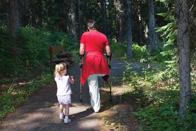
About the Authors
Janet Zeller is the national accessibility program manager for the Forest Service and is based in Washington, DC. She began her Forest Service career in 1991 and has worked in the field of accessibility for more than two decades. She is the team leader for the Forest Service accessibility program and for the development and implementation of the program and accessibility policies. She also teaches accessibility and universal design for programs and facilities at a wide range of training sessions nationally. She holds a bachelor's degree in education from the University of New Hampshire and a master's degree from the University of Rhode Island.
Ruth Doyle is the recreation, engineering, archeology, lands, and minerals staff officer at the Cibola National Forest. She was the Forest Service's representative on the U.S. Access Board's Outdoor Developed Areas Regulatory Negotiation Committee. This committee developed the preliminary accessibility guidelines for picnic areas, campgrounds, beach access routes, and trails on which the Outdoor Developed Areas Accessibility Guidelines are based. She has a master's degree in landscape architecture from the University of Massachusetts, Amherst, and is a registered landscape architect in New Mexico.
Kathleen Snodgrass came to the Missoula Technology and Development Center (MTDC) as a project leader in 2001 She began her career with the Forest Service at the Nez Perce National Forest, working in facilities, landscape architecture, land line, and general engineering before serving as the facilities architect for about 7 years. She also spent about 10 years working in highway design and construction with the Idaho Division of Highways after graduating from Washington State University in 1974 with a bachelor's degree in architectural studies.
Additional single copies of this publication may be ordered from:
USDA Forest Service
Missoula Technology and Development Center
5785 Hwy. 10 West
Missoula, MT 59808–9361
Phone: 406–329–3978
Fax: 406–329–3719
Email: wo_mtdc_pubs@fs.fed.us
Electronic copies of MTDC's documents, CDs, DVDs, and videos are available on the Internet at:
http://www.fs.fed.us/eng/pubs
Forest Service and Bureau of Land Management employees can search MTDC's documents, CDs, DVDs, and videos on their internal computer networks at:
http://fsweb.mtdc.wo.fs.fed.us/search/
For additional technical information, contact MTDC
Phone: 406–329–3900
Fax: 406–329–3719
User Comments/Questions
Add Comment/Question