Applying the Forest Service Trails Accessibility Guidelines
The first step in applying the Forest Service Trails Accessibility Guidelines (FSTAG) is to know when and where compliance is required. Section 7.0 "Application" states that FSTAG applies to trails in the National Forest System that meet all three of the following criteria:
-
The trail is new or altered.
-
The trail has a "Designed Use" of "Hiker/Pedestrian" as defined in the Federal Trail Data Standards.
-
The trail connects either directly to a trailhead or to a trail that meets most of the accessibility requirements.
FSTAG doesn't apply to existing trails unless there is a change in the purpose, intent, or function of the trail—an alteration, in other words. It doesn't apply to trails designed for all-terrain vehicle (ATV), equestrian, or any other nonpedestrian use. FSTAG only applies to trails that have been designed for "Hiker/Pedestrian" use in accordance with the Federal Trail Data Standards (FTDS). Information about FTDS is available at http://www.nps.gov/gis/trails/.
FSTAG doesn't prescribe different "levels of accessibility" based on trail class or any other grouping criteria. FSTAG provides guidance for maximizing accessibility, while recognizing and protecting the unique characteristics of the natural setting, level of development, and purpose of each trail.
Cost is not a valid reason for failing to make a trail accessible. (See BUDGET TIP—Extra cost is not an excuse., page 31.) FSTAG won't apply to most portions of existing primitive, long-distance trails. It may, however, apply to new segments that pass through developed areas. FSTAG recognizes, however, that there is no real benefit in making a newly constructed or altered trail in the backcountry accessible if the only way to get to it is by using an existing trail that isn't accessible and probably can't be made accessible.
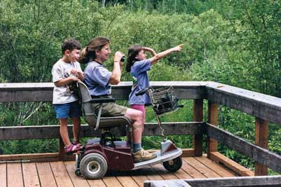
By applying FSTAG, you will ensure that the full range of trail opportunities continues to be provided. Hiking opportunities to highly developed interpretive trails, popular scenic overlooks, and more remote areas will be options for everyone (figure 119).
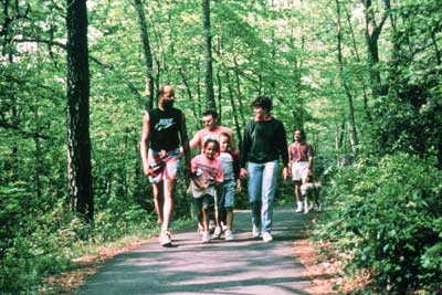
Figure 119—Compliance with the trail accessibility guidelines allows everyone to enjoy hiking.
Trails Are Not Outdoor Recreation Access Routes
An outdoor recreation access route is a continuous, unobstructed path designated for pedestrian use that connects pedestrian elements within a recreation site, such as a picnic area, camping area, or trailhead. In contrast, a trail is defined for purposes of Forest Service Outdoor Recreation Accessibility Guidelines (FSORAG) and FSTAG as a route that is designed, constructed, or designated for recreational pedestrian use or provided as a pedestrian alternative to vehicular routes within a transportation system. A trail is not an outdoor recreation access route and is not subject to the requirements for outdoor recreation access routes found in section 2.0 of FSORAG. This guidebook explains the accessibility requirements for trails designed for hiker and pedestrian use.
Trail Terminology
Although this guidebook explains requirements in plain language, some phrases and words are important to understanding how FSTAG is applied. The following terminology isn't organized alphabetically; the phrases and words are grouped so that the distinctions between similar terminology are easy to understand.
Federal Trail Data Standards (FTDS) enable national-, regional-, State-, and trail-level managers, and the public, to use mutually understood terminology for recording, retrieving, and applying spatial and tabular information. FTDS make it easier for trail information to be accessed, exchanged, and used by more than one individual, agency, or group. The data standards are available at http://www.nps.gov/gis/trails/Doc2/Federal_Trail_Data_Standards_Final_20111108.pdf.
Designed Use is the "Managed Use" of a trail that requires the most demanding design, construction, and maintenance parameters. In conjunction with the applicable "Trail Class," designed use determines which design parameters will apply to a trail. It is an FTDS term for the intended use that controls the geometric design of a trail and determines the level to which it should be maintained. There is only one "Designed Use" per trail or trail segment. Although the trail may be actively managed for more than one use, the designed use determines the technical specifications for the trail. For example, pack and saddle stock require higher and wider clearances than do hikers, so a trail managed for both foot travel and horse use would have a designed use of "Pack and Saddle" rather than "Hiker/Pedestrian." More information about trail design parameters for the different designed uses is in Forest Service Trail Design Parameters, available at http://www.fs.fed.us/recreation/programs/trail-management/trail-fundamentals/ or available to Forest Service employees at http://fsweb.wo.fs.fed.us/rhwr/ibsc/docs/trails/national_design_parameters_2008-10-16.doc.
Managed Use is an FTDS term for the mode(s) of travel for which a trail is actively managed. Managed Uses are the specific types of trail use that are allowed by management decision or intent on a specific trail or portion of a trail. Each trail or trail segment may have more than one "Managed Use." For example, a trail may be managed for both equestrian and hiker/pedestrian use in the summer and for cross-country skiing in the winter.
Constructed Features are commonly found along trails or as part of trails.
-
Associated Constructed Feature—A constructed element associated with a trail that provides support for trail users but is not a part of the trail tread. Examples include camp shelters, pit toilets, fire rings, picnic tables, and tent pads. Refer to FSORAG for the technical provisions for associated constructed features.
Trail Constructed Feature—A constructed feature that functions as part of the trail tread. Examples include puncheon, trail bridges, boardwalks, waterbars, and switchbacks. For a listing of trail constructed features, refer to the trail documentation available at http://www.fs.fed.us/recreation/programs/trail-management/index.shtml or available to Forest Service and Bureau of Land Management employees at http://fsweb.wo.fs.fed.us/rhwribsc/tr-cost.shtml.
A trailhead (for purposes of FSORAG and FSTAG) is a site designed and developed by the Forest Service or other Government agency, a trail association, trail maintaining club, trail partner, or other cooperators to provide a staging area for a trail.
For purposes of FSTAG, trailheads are not:
-
Junctions between trails where there is no other access
-
Intersections where a trail crosses a road or where users have developed an access point, but no improvements are provided by the Forest Service, trail associations, trail maintaining clubs, trail partners, or other cooperators beyond minimal markers or modifications for health and safety
Trail Classes broadly organize trails by desired management characteristics and the level of development. They are based on forest plan direction and represent intended design and management standards. Trail classes take into account user preferences, the setting, protection of sensitive resources, and management activities. Trail classifications range from Trail Class 1 trails that appear little different from animal paths and may disappear intermittently, to Trail Class 5 trails that are usually wide, paved paths associated with highly developed environments. FSTAG does not change Forest Service trail classes. More information about trail classes is available at http://www.fs.fed.us/recreation/programs/trail-management/trail-fundamentals/.
Setting is the word used to describe the nature of the surroundings of a trail. On public lands outside rural and urban settings, the natural surroundings are usually the primary attraction for visitors. Improvements, such as trails, should not adversely affect the setting. For example, the design for a trail crossing a glacial boulder field must protect the geologic features. Accessibility is incorporated to the extent possible without fundamentally altering the natural environment. On the other hand, a trail designed for a wide open, relatively level area should follow the requirements of FSTAG to the highest degree possible.
The following words describe construction and maintenance work:
-
Construction is building a new trail or segment of trail where there was no trail before.
-
An alteration is work done to change the purpose, intent, or function of the trail.
-
Maintenance is the routine or periodic repair of existing trails or trail segments to restore them to the standards or conditions to which they were originally designed and built. Maintenance does not change the original purpose, intent, or function for which the trail was designed. Trail maintenance work isn't covered by the FSTAG. Maintenance includes:
-
Removing debris and vegetation, such as fallen trees or broken branches on the trails, clearing the trail of encroaching brush or grasses, and removing rock slides
-
Maintaining trail tread, such as filling ruts, reshaping a trail bed, repairing a trail surface or washouts, installing riprap to retain cut and fill slopes, and constructing retaining walls or cribbing to support trail tread
-
Performing erosion control and drainage work, such as replacing or installing drainage dips or culverts, and realigning sections of trail to prevent erosion or to avoid boggy areas
-
Repairing or replacing deteriorated, damaged, or vandalized trail or trailhead structures or parts of structures, including sections of bridges, boardwalks, information kiosks, fencing, and railings; painting; and removing graffiti
-
While FSTAG doesn't apply to maintenance, Forest Service policy is to improve accessibility wherever the opportunity arises, including during trail maintenance and repair activities. Every time a trail is maintained, there is an opportunity to improve access.
The word "reconstruction" is not used in Federal accessibility guidelines or FSTAG, even though the term is used frequently by the trails community. For the purposes of FSTAG, actions are categorized as construction, alteration, or maintenance.
Terminology Tip
What do you call a reroute?
If trail work is grouped into only three categories— construction, alteration, and maintenance—what category do things like rerouting, reconstruction, and extensions of existing trails fall into? The key to answering this question is to concentrate first on the definition of alterations. Does the new work change the purpose, intent, or function of the trail? In other words, will the trail serve a new destination? Will the trail's designed use change from horses to hikers, for example, after you're done? Are you significantly changing the overall trail grade, width, or surface, or adding bridges where the trail used to ford streams or rivers? If the work doesn't fit the definition of alteration, it's either construction (if there was no trail there before) or maintenance.
Trail Construction Techniques
Information that is already available to Forest Service employees is not repeated in this guidebook. The "Trail Construction and Maintenance Notebook" includes practical techniques used to construct and maintain trails. Written for trail crew workers, it is intended to be taken along on work projects. Numerous illustrations help explain the main points. The notebook is at http://www.fhwa.dot.gov/environment/fspubs/07232806/index.htm.
ETA Editor's Note
The above referenced "Trail Construction and Maintenance Notebook" is now located here: https://www.fhwa.dot.gov/environment/recreational_trails/publications/fs_publications/07232806/index.cfm
The publication "Wetland Trail Design and Construction" describes materials and techniques used to construct trails in wetlands. Written primarily for workers who are inexperienced in wetland trail construction, it may also be helpful for experienced workers. Techniques suitable for wilderness settings and for more developed settings are included as well as numerous drawings to illustrate important points. The publication is available at http://www.fs.fed.us/eng/pubs/htmlpubs/htm07232804/index.htm or http://www.fhwa.dot.gov/environment/fspubs/07232804/index.htm.
ETA Editor's Note
The above referenced "Wetland Trail Design and Construction" is now located here: https://www.fhwa.dot.gov/environment/recreational_trails/publications/fs_publications/01232833/
Standard Forest Service trail specifications are available at http://www.fs.fed.us/database/acad/dev/trails/trails.htm.
Conditions for an Exception in FSTAG
FSTAG is based on the realities of the outdoor environment and recognizes that complying with accessibility provisions is not always practicable because the natural terrain, existing vegetation, or other constraints impose limitations in some locations. To ensure that the unique characteristics of the outdoor environment and trail recreation opportunities aren't compromised or fundamentally altered, exceptions and deviations from some technical requirements are permitted when certain circumstances, called conditions for an exception, apply.
The following paragraphs explain the four conditions for an exception identified in section 7.1 of the FSTAG. Circumstances under which deviations from the technical requirements are allowed based on the conditions for an exception differ depending on the setting. The four conditions for an exception are the basis for permitting deviations from specific technical requirements when allowed by General Exception 1 or General Exception 2, as explained in "General Exceptions in FSTAG."
Conditions for an exception are not blanket exemptions from all of the technical requirements for an entire trail. If a condition for an exception occurs only on part of the trail or trail component, the technical requirement applies everywhere else. All technical requirements not affected by the condition for an exception also apply. This requirement is explained in "General Exceptions in FSTAG."
The conditions for an exception cover all the important elements of a long-distance trail and the aspects that are considered when locating trail segments, but they shouldn't be used as an excuse or loophole for failing to make trails accessible. Rather, they are to be used when all other design options have been thoroughly explored and a determination has been made that full compliance with the technical requirements would unacceptably alter the nature of the experience the visitor is seeking or unacceptably impact features that are protected by law.
The wording of each exception is brief. General examples for each exception are provided to help explain the intent of the conditions so that designers understand how to apply them according to the site-specific constraints and opportunities of their projects.
Condition for an Exception 1. Where compliance with the technical requirement is not practicable due to terrain (figure 120).
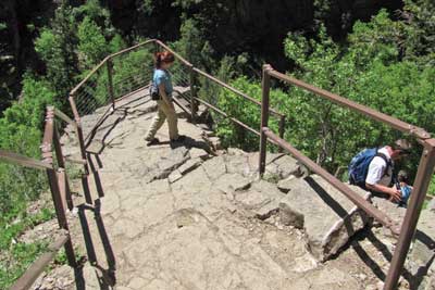
Figure 120—Compliance with the technical requirements on the trail to Hanging Lake at the White River National Forest is not practicable due to the extreme slope of the terrain.
The phrase "is not practicable" in this condition for an exception refers to something that isn't reasonable, rather than to something that is technically impractical. The intent of this condition is that the effort and resources required to comply shouldn't be disproportionately high relative to the level of access established.
Condition for an Exception 2. Where compliance with the technical requirements would fundamentally alter the function or purpose of the facility or the setting.
Public lands provide a wide variety of recreational experiences, from highly developed areas that offer plenty of conveniences and opportunities to relax with family and friends, to wilderness areas that appear unchanged from primeval times and provide opportunities for individuals to experience primitive and challenging conditions. FSTAG recognizes the value of the full range of recreation opportunities by allowing deviations from the technical requirements where compliance would unacceptably change the nature of the recreation opportunities or conflict with the land and the resource management plan for the area.
People using primitive trails, for example, experience the outdoor environment in a nearly natural state, with limited or no development. In these settings, people generally desire challenge and risk so they can use their outdoor skills. Use of manufactured building materials or engineered construction techniques to comply with accessibility provisions could destroy the natural or undeveloped nature of the setting and change the visitor's experience. FSTAG does not require that obstacles be blasted or trails paved to be more accessible if such activity would unacceptably change the character of the setting and the recreation opportunity.
Terminology Tip
What's practicable?
Using heavy construction equipment, it may be possible to provide a trail with a maximum 1:20 (5 percent) grade up a 1,500-foot (460-meter) mountain (figure 121). However, the trail would be about three times as long as under a traditional back-country layout (figure 122). The length of the trail could cause inappropriate environmental and visual impacts and more than triple the amount of ground disturbed. It wouldn't be practicable to construct a trail in compliance with technical accessibility requirements.
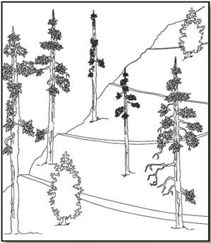
Figure 121—A trail with a 5-percent grade on a steep hill.
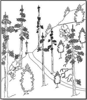
Figure 122—A traditional trail layout for a steep hill.
Consider a trail intended to provide a rugged experience, such as a cross-country training trail with a steep grade or a fitness challenge course with abrupt and severe changes in elevation. If these trails were flattened out or otherwise constructed to comply with the technical accessibility requirements, they wouldn't provide the desired challenge for users. Trails that traverse boulders and rock outcroppings are another example. The purpose of these trails is to provide users with the opportunity to climb the rocks. To remove the obstacles along the way or reroute the trail around the rocks would destroy the purpose of the trail. The nature of the setting also may be compromised by actions such as widening a trail for an imported surface or removing vegetation from fragile or erosive soils.
Condition for an Exception 3. Where compliance with the technical requirements cannot be accomplished with the prevailing construction practices.
This condition for an exception may apply when the construction methods needed to comply with a technical requirement would require the use of equipment or methods other than those typically used in that setting. For instance, in an area where small equipment is normally used to minimize impact on a sensitive adjacent stream, blasting might be necessary for rock removal to meet the technical width requirement for a trail. Because blasting typically would not be used in this situation, this condition for an exception would apply. If the work could be done using small equipment, this condition for an exception wouldn't apply.
This condition for an exception is not intended to exempt the trail from the technical requirements of FSTAG simply because a trail builder's favorite construction practice (such as the use of a large mechanical roller rather than a smaller vibrating plate or "whacker" type compactor) is inappropriate or impractical. A contractor's or designer's preference for different equipment is not a prevailing construction practices issue. A deviation from a specific technical requirement only can be allowed if the equipment is essential to complete the construction in that location.
Condition for an Exception 4. Where compliance is precluded because the cultural, historic, or significant natural features are protected or are eligible for protection under Federal, State, or local law by:
-
Endangered Species Act (16 U.S.C. 1531 et seq.)
-
National Environmental Policy Act (42 U.S.C. 4321 et seq.)
-
National Historic Preservation Act (16 U.S.C. 470 et seq.)
-
Wilderness Act (16 U.S.C. 1131 et seq.)
-
Other Federal, State, or local law (the purpose of which is to preserve threatened or endangered species; the environment; or archaeological, cultural, historical, or other significant natural features)
Cultural features include archeological sites, burial grounds and cemeteries, traditional cultural properties, tribal protected sites, and other properties considered sacred by an organized religion. Historical features are properties listed or eligible for listing on the National Register of Historic Places or other places of recognized historic value. Significant natural features are objects that are regarded as distinctive or important locally, regionally, or nationally and, therefore, have been placed under legal protection, such as a large boulder or rocky outcrop, body of water, or unique tree or vegetation such as a giant sequoia grove (figure 123). Areas that are legally protected include wilderness areas designated by Congress and areas protected under Federal or State laws, such as habitat for threatened or endangered species or designated wetlands.
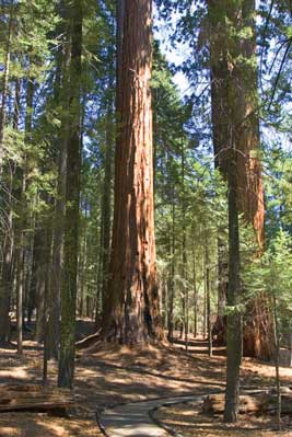
Figure 123—The Long Meadow grove of giant sequoias is an example of a significant natural feature.
Situations when this condition for an exception may apply include these examples:
-
Where use of mechanized equipment is prohibited by law, such as in wilderness areas designated by Congress, and work necessary to comply with a technical accessibility provision can't be accomplished using handtools
-
Where imported materials, such as soil stabilizers, are prohibited to maintain the integrity of a natural ecosystem or historic resources
-
Where construction methods and materials are strictly limited to protect designated wetlands or coastal areas
-
Where the physically undisturbed condition of the land is an important part of a sacred observance, such as at tribal sacred sites
-
Where water crossings are restricted to safeguard aquatic features or species protected under Federal or State laws
The Federal laws specified in Condition 4 prescribe certain activities or require certain analyses or procedures to be followed when planning projects that may impact features protected under those laws. This condition for an exception applies when it is determined that the actions, required analyses, or other impacts necessary to meet the technical requirements would directly or indirectly substantially harm the protected feature.
Design Tip
Determine the extent of impact.
Only consider the additional impact of increasing the width, reducing the trail grade or cross slope, or other change required for accessibility. For example, consider a trail project that crosses a hill where a population of wildflowers of an uncommon species is growing. The surrounding river drainage and a nearby town are named for the plants. The trail construction will destroy most of the flowers, as well as the seep-dampened hanging meadow that provides their habitat. Condition 4 wouldn't apply if 323 square feet (30 square meters) would be disturbed to construct a trail that is not accessible and only an additional 75 square feet (7 square meters) would be disturbed to construct a trail that meets the technical accessibility requirements. The majority of the proposed damage to the wildflowers is not attributable to compliance with accessibility requirements. In this case, an alternate location should be selected for the trail.
General Exceptions in FSTAG
Some public lands are reasonably well suited for pedestrian travel. Other public lands are rocky, soggy, excessively steep, or otherwise less well suited to casual foot traffic. Two general exceptions are provided in FSTAG, section 7.2 to ensure that accessibility is provided to the extent appropriate to the setting where it will have the most benefit, be practicable, and provide a meaningful hiking opportunity.
Document the basis for the determination that either of the general exceptions applies to a trail or a portion of a trail and maintain the documentation with the records of the construction or alteration project. In addition, if General Exception 2 applies, send notification to the U.S. Access Board. Documentation and notification requirements are explained in "Documenting Exceptions and Notifying the U.S. Access Board about Exemptions" of this guidebook.
General Exception 1 allows deviations from the technical requirements if a condition for an exception prohibits full compliance. It's not a complete exemption from the provision, because it requires that the technical requirement must still be met to the extent practicable.
For instance, if Condition for an Exception 3 prohibits importing several tons of stabilization material to ensure that the surface of a trail in a nonmotorized area will be firm and stable during the primary season(s) of use under normally occurring weather conditions, you must still make sure the surface is as firm and stable as is practicable. For instance, if relocating a section of trail a few feet laterally will achieve firmness and stability with native soils during the dry portion of the season or even during part of the wetter season, you must relocate that section. Such measures are practicable and should be utilized. General Exception 1 only applies to the portion of the trail where the condition for an exception exists. On all other sections of the trail, ensure that technical requirements are met. All of the unaffected technical requirements must be met for the full length of the trail, including the section where the condition for an exception prohibits full compliance with the particular technical requirement. Practicable means reasonable rather than technically possible. (See TERMINOLOGY TIP—What's practicable?, page 32.)
Another example of the use of General Exception 1 is when construction of a trail appears to fall under Condition for an Exception 4, where compliance is not possible because the cultural, historic, or significant natural features are protected or are eligible for protection under Federal, State, or local law. For instance, consider a situation where a trail is needed between a stream with endangered aquatic species and a cliff with petroglyphs on it and you can't get the required trail width without either filling part of the stream or destroying some petroglyphs. A narrower trail would be allowed past the petroglyphs. However, the other technical requirements still apply to that stretch of trail and the technical requirement for width still applies to all the rest of the trail.
Design Tip
Compliance is required on both sides of a deviation from the technical requirements.
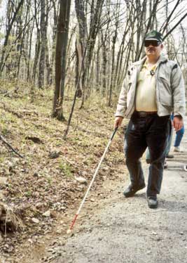
Although accessible design is based on wheelchair dimensions, clear space, maneuvering room, and reach ranges, only 4 percent of people with disabilities use wheelchairs. The majority of people who have mobility limitations don't use a wheelchair. They either use no assistive devices or rely on crutches, canes, walkers, or braces. They may be able to get around or over an obstacle without too much difficulty. Although steep terrain may be difficult, it may be manageable for limited distances.
Likewise, a person using a wheelchair might need assistance to make it up a steep grade (figure 124) or to get over an obstacle, but after that challenge, the individual can continue on the trail independently if the rest of the trail complies with the accessibility guidelines.
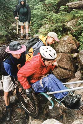
Figure 124—Members of the Northeast Passage hiking team assist their teammate up a steep part of the Galehead Trail. She only needs assistance for a short distance. Photo credit: Northeast Passage, Durham, NH
General Exception 2 addresses extreme environmental barriers that are effectively impassable and trails with numerous environmental barriers that can't be eliminated. These barriers can make the rest of the trail unreachable for many people with mobility limitations. General Exception 2 may be considered only after applying General Exception 1 so that the trail sections where full compliance with the technical requirements can't be achieved are identified. Then evaluate the entire trail comparing the trail sections that can and can't meet the full technical requirements to determine whether it would be impracticable for the entire trail to comply with the accessibility requirements.
The following condition criteria have been accepted by the U.S. Access Board for identifying when extreme environmental barriers may exempt an entire trail from technical accessibility requirements:
-
A combination of running slope and cross slope exceeds 1:2.5 (40 percent) for more than 20 feet (6 meters) (figure 125).
-
An obstacle 30 inches (760 millimeters) high or more crosses the full tread width of the trail (figure 126).
-
The surface of the trail is neither firm nor stable for a distance of 45 feet (14 meters) or more.
-
The tread width of the trail is 12 inches (305 millimeters) or less for a distance of 20 feet (6 meters) or more.
-
15 percent or more of the trail does not fully comply with the technical requirements.
Figure 125—The combination of running slope and cross slope on the trail to Hanging Lake is so severe for such an extended distance that the entire trail was exempted from the technical requirements.
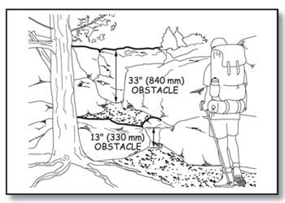
Figure 126—The 33-inch (840-millimeter) rock face is an example of an extreme environmental barrier.
Some long-distance trails, such as the Continental Divide, Pacific Crest, Appalachian, and Florida National Scenic Trails and the Nee-Me-Poo National Historic Trail, span many districts or forests. For these trails, only the length of trail planned for construction or alteration within the current planning period is considered when figuring the 15 percent, not the entire length of the trail. This principle applies even if the planning period is several years long. Consider connected sections of trail that will be constructed or altered over several years, together. Do not consider unconnected segments of trail that are covered by the same planning process together, unless there is a special circumstance where several segments function together to access one attraction or serve one purpose.
Short Hikes and Interesting Features
Sometimes it makes sense to provide a short section of trail meeting the technical requirements for accessibility on a trail that would otherwise be totally exempted from the technical requirements under General Exception 2. Even if visitors can't hike the entire trail, a short hike may be enjoyable (figure 127). If there are no uncorrectable environmental barriers and few or no significant conditions requiring exceptions between the trailhead and the first extreme environmental barrier, and that trail segment is at least 500 feet (152 meters) long, consider constructing that section of trail to meet the technical requirements even though the rest of the trail is not accessible.
A short section of trail is especially enjoyable if an interesting natural, cultural, or historic feature is located between the trailhead and the first extreme environmental barrier. The feature might be the focal point, main attraction, or destination of the trail or it may simply be an interesting secondary feature, such as a boulder outcrop, a waterfall, a grouping of old or unique trees, a cultural or historic structure, a wildflower meadow, an area popular for wildlife viewing, or a vista. In such cases, hikers would appreciate you constructing the section of the trail leading to the prominent feature in compliance with the technical accessibility requirements.
Here's an example of how the guidance on General Exception 2 can be used. Consider the design for a new 1-mile (1,600-meter) -long trail with a waterfall (an interesting feature) about 300 feet (91 meters) from the trailhead. Fifteen percent of 1 mile (1,600 meters) is 792 feet (240 meters). Add together all the lengths of trail where technical requirements can't be met because of conditions for an exception. If the total length is more than 792 feet (240 meters), the trail would be eligible for a total exemption from the technical requirements of FSTAG. However, if there are no uncorrectable environmental barriers and few or no significant conditions requiring exceptions between the trailhead and the waterfall, that section of trail should, in most cases, comply with the technical requirements even though the rest of the trail does not.
Documenting Exceptions and Notifying the U.S. Access Board About Exemptions
U.S. Access Board About Exemptions When a condition for an exception prohibits full compliance with a specific technical requirement on a section of trail as allowed in General Exception 1, document the reason that full compliance wasn't achieved and file it with the project records for the trail construction or alteration project. Include which condition for an exception applies to the trail or segment of trail, the reason that it applies, the date the decision that the exception applies was made, and the names of the individuals who made the decision.
Infrequently, extreme or numerous conditions for exemptions make it impracticable to provide a route that meets the requirements, so General Exception 2 allows exempting the entire trail from the technical requirements. In these cases, document the explanation of the conditions that make it impracticable for the entire trail to comply. Retain the documentation with the records for that construction or alteration project. Notify the U.S. Access Board of the determination to exempt the entire trail. Contact information for the U.S. Access Board is available at http://www.access-board.gov/. The U.S. Access Board has drafted a form that may be used to document and submit an exemption decision. The form will be available at http://www.access-board.gov/guidelines-and-standards/recreation-facilities/outdoor-developed-areas when the U.S. Access Board final guidelines are published.
Technical Requirements for Accessible Hiker/Pedestrian Trails
Section 7.4 of FSTAG explains the accessibility requirements for trails, including trail surfacing, clear tread width, grade and cross slope, resting intervals, passing spaces, tread obstacles, protruding objects, openings, and signs. All of these requirements are minimums. In the spirit and intent of universal design, designers are encouraged to meet the highest standards wherever it is practicable, given the specific natural constraints of the environment, the level of development, and other managerial considerations. Trail puncheons and trail bridges are included in the Forest Service definition of trail structures, so they must be constructed to meet the same requirements as the rest of the trail tread. In the following text, the word "trail" includes trail puncheons and trail bridges.
Wheelchair dimensions, clear space, maneuvering room, and reach ranges found in Architectural Barriers Act Accessibility Standards (ABAAS) are the basis for trail designs that maximize accessibility and are appropriate to the setting. The dimensions, multiple moving surface contact points, and wheels of a wheelchair are usually the most difficult to accommodate. If a person who uses a wheelchair can use a trail, a majority of other people can, too.
The rest of this part of the guidebook explains the technical accessibility requirements for trails and provides an overview of the FSTAG implementation process and a flowchart of the FSTAG implementation process. The flowchart is designed to be used while laying out the flag line for a trail.
Surfaces of Trails
Trail surfaces must be firm and stable. The first general exception allows achieving firmness and stability to the extent practicable if a condition for an exception prohibits full compliance with surface requirements.
Paving with concrete or asphalt is appropriate for highly developed areas. For less developed settings, crushed gravel, fine crusher rejects, packed soil, and other natural materials may provide a firm and stable surface (figure 128). Natural materials also can be combined with synthetic bonding materials that provide stability and firmness. These materials may not be suitable for every trail, which is why the deviation due to the presence of a condition for an exception is permitted.
Figure 128—Natural materials were used to build a firm and stable surface for the Crotched Mountain Trail in New Hampshire.
Slip resistance is not required for trails. Tree and shrub leaves and needles, dirt, ice, snow, other surface debris, and weather conditions are part of the natural environment and would be difficult, if not impossible, to avoid.
FSTAG defines a firm surface as one that resists deformations by indentations. (See DESIGN TIP—Use a rule of thumb to estimate firmness and stability., page 37.) Natural soils should be evaluated for their ability to be compacted into a firm and stable surface under normally occurring weather conditions during the primary season of use. When evaluating surface material suitability, keep in mind that FSTAG defines a stable surface as a trail surface that is not permanently affected by normal weather conditions and that is able to sustain wear and tear produced by normal use between planned maintenance cycles. Local trail managers are a good source of information because they know the local surfaces and how they wear throughout the primary seasons for which the trail is managed.
Clear Tread Width of Trails
Clear tread width is the width of traveled surface between obstacles on the ground and above the ground (figure 129). Provide at least 36 inches (915 millimeters) of clear tread width. An exception permits the width to be reduced to 32 inches (815 millimeters) minimum if a condition for an exception prevents the wider tread. If even the reduced width of 32 inches can't be met due a condition for an exception, the first general exception allows achieving the width requirement to the extent practicable.
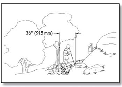
Figure 129—The requirements for clear tread width on a trail.
Trail Slopes
Trail slopes must meet the requirements that follow. Steeper terrain makes it difficult to achieve flat grades everywhere. Many people are able to handle steeper slopes for short distances. Short sections of steeper trail are allowed so that trails can be constructed in varying terrain. The first general exception allows achieving trail slopes to the extent practicable if a condition for an exception prohibits full compliance with slope requirements
Running slope is the lengthwise slope of a trail, parallel to the direction of travel. In this guidebook, the terms running slope and grade often are used interchangeably. Trails or trail segments of any length may be constructed with a running slope ratio of up to 1:20 (a 5-percent grade). To accommodate steep terrain, trails may be designed with shorter segments that have a running slope (grade) and length as shown in table 5.
Table 5—Trail running slope and segment length.
| Running Slope of Trail Segments | Maximum Length of Segment Between Resting Intervals | |
|---|---|---|
| Steeper than | But no Steeper than | |
| 1:20 (5 percent) ) | 1:12 (8.33 percent) | 200 feet (61 meters |
| 1:12 (8.33 percent) | 1:10 (10 percent) | 30 feet (9 meters) |
| 1:10 (10 percent) | 1:8 (12 percent) | 10 feet (3.05 meters) |
Provide a resting interval between each of these steeper slope segments. To ensure that the trail is not designed as a series of steep segments, do not exceed a grade of 1:12 (8.33 percent) for more than 30 percent of the total length of the trail. The running slope (grade) must never exceed 1:8 (12 percent).
Construction Tip
Slope and grade terminology.
Slopes are often described as a ratio of vertical distance to horizontal distance, or rise to run (figure 130). For instance, a slope ratio of 1:20 means that for every foot of vertical rise, there are 20 feet of horizontal distance (or for every meter of vertical rise, there are 20 meters of horizontal distance).
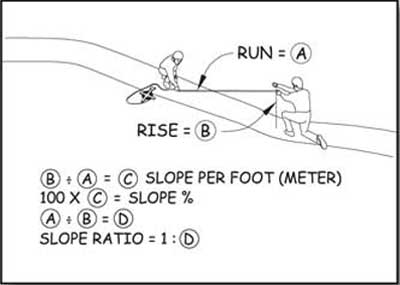
Figure 130—Determining the slope ratio.
Cross slopes—the side-to-side slope of a trail tread (figure 131)—provide drainage to keep water from ponding and damaging the trail, especially on unpaved surfaces. Cross slopes that are too steep can be difficult to traverse, but trails with too little cross slope tend to become streams. Water running down or ponding on trails destroys them. Cross slopes are an important part of trail design and construction.
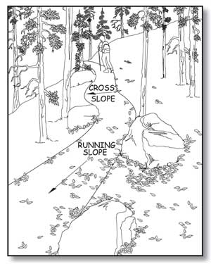
Figure 131—The running slope is measured along a trail's length; the cross slope is measured across its width.
Ensure that cross slopes do not exceed 1:20 (5 percent). If the trail surface is paved or built with boards, however, do not allow the cross slope to be steeper than 1:48 (2 percent).
Resting Intervals on Trails
Resting intervals are relatively level areas that provide an opportunity for people to stop and catch their breath. Provide resting intervals between each trail segment any time the running slope exceeds 1:20 (5 percent) as shown in table 5. Ensure that the resting interval is at least 60 inches (1,525 millimeters) long and at least as wide as the widest segment of the trail tread leading into it, if the resting interval is within the trail (figure 132). If the resting interval is beside the trail, ensure that it is at least 60 inches (1,525 millimeters) long and at least 36 inches (915 millimeters) wide. If the resting interval is adjacent to the trail tread, provide a turning space complying with ABAAS section 304.3.2. This doesn't mean that another space must be provided for turning around or as a passing space in addition to the resting space. The resting space itself may also serve as the turning and passing space if it is at least 60 inches (1,525 millimeters) in diameter or is T-shaped with a minimum 60- by 36-inch (1,525-by 915-millimeter) arm and a minimum 36-inch (915-millimeter) -wide by 24-inch (610-millimeter) -long base (figure 133).
Design Tip
The cross slope requirement depends on what material is used.
Those who use a manually operated wheelchair or a walker know that as cross slope increases, travel becomes more difficult. This is because working against the sideways pull of the cross slope can double the effort needed to make forward progress. However, in an outdoor environment, the cross slope has to be steep enough that water won’t accumulate on the travel surface. While slope and drainage can be precisely controlled on surfaces that are paved (asphalt, concrete, paving blocks, and so forth) or built with boards (wood planks, heavy timber, concrete, fiberglass, or other manufactured material), it’s more difficult to ensure drainage on natural or gravel surfaces. When water accumulates on natural or gravel surfaces, they often become muddy and impassible. That’s why the cross slope is allowed to be steeper on natural or gravel surfaces than on surfaces that are paved or built with boards.
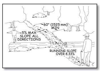
Figure 132—The requirements for resting intervals.
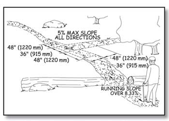
Figure 133—The requirements for a resting interval at a T-intersection.
The slopes of a resting interval must not exceed 1:20 (5 percent) in any direction. However, when the surface is paved or is built with boards, the slope is not allowed to be steeper than 1:48 (2 percent) in any direction. No significant difference in vertical alignment between the trail tread, turning space, and resting interval is allowed where they meet. The first general exception allows achieving resting interval requirements to the extent practicable if a condition for an exception prohibits full compliance with the requirements.
Passing Spaces on Trails
A 60-inch (1,525-millimeter) clear tread width is required for two wheelchairs to pass safely and comfortably on a trail. However, this width is not always appropriate in all settings and for all trail classes. Where the clear tread width of a trail is less than 60 inches (1,525 millimeters), provide passing spaces at least every 1,000 feet (300 meters) and at the end of any segment of trail that meets the technical requirements, if the full length of the trail does not. Passing spaces must be at least 60 inches (1,525 millimeters) wide (including the trail width) by 60 inches (1,525 millimeters) long (figure 134). A T-intersection of two trails or other walking surfaces also may be used as a passing space if the arms and stem of the T-shaped space extend at least 48 inches (1,220 millimeters) beyond the intersection (figure 135). Either configuration would provide enough room for someone to move to the side. If a condition for an exception prevents achieving full compliance with the passing space requirements, the first general exception allows achieving passing space requirements to the extent practicable.
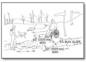
Figure 134—The requirements for passing spaces.
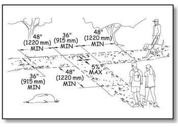
Figure 135—The requirements for passing spaces at T-intersections.
Tread Obstacles on Trails
A tread obstacle is anything that interrupts the evenness of the tread surface. On trails, tread obstacles often occur as a result of ruts, roots, and rocks in the tread surface. Ensure tread obstacles are not more than 2 inches (50 millimeters) high. Where the surface is paved or is built with boards, ensure tread obstacles do not exceed one-half inch (13 millimeters) in height. Height of tread obstacles must be measured vertically from the trail tread surface to the highest point of the obstacle. If a condition for an exception prevents achieving full compliance with the obstacle height requirements, the first general exception allows achieving the requirements to the extent practicable.
Protruding Objects and Trails
Objects that extend into the travel way of a trail from the side or from overhead can be hazardous to people who are paying more attention to their companions than the travel route (figure 136), as well as to people who are blind or have low vision. Protruding objects are defined as constructed features such as signs that extend into the clear width area of a trail, resting interval, or passing space between 27 inches (685 millimeters) and 80 inches (2,030 millimeters) above the travel surface. Do not allow protruding objects to extend into the clear width area more than 4 inches (100 millimeters).
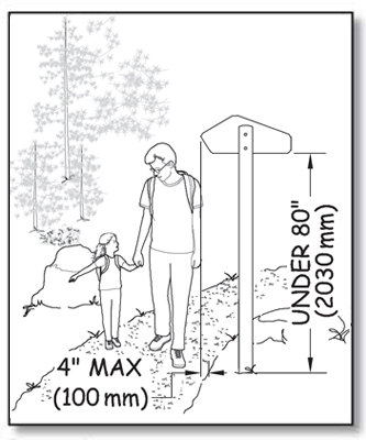
Figure 136—Constructed objects must not extend over the trail more than 4 inches (100 millimeters) if they are between 27 inches (685 millimeters) and 80 inches (2,030 millimeters) above the travel surface.
Accessibility guidelines do not consider natural elements such as tree branches and rock formations to be protruding objects. However, you should follow the specific Trail Management Objectives for each trail that address protrusions, obstacles, and clearing widths and heights. For instance, trails should generally not be routed too close to rock overhangs. Clearing limits for trail construction and maintenance usually require that brush, limbs, trees, and logs be cut back a foot or more from the edge of the trail. However, the trail maintenance cycle may be several years for some trails, and vegetation may encroach on the trail during the interim. The protruding object requirement recognizes that it may not always be practicable to control vegetation, but it is always practicable to place constructed features where they won't interfere with hikers. It also recognizes situations where rock ledges are unavoidable or where trails pass through caves (figure 137).
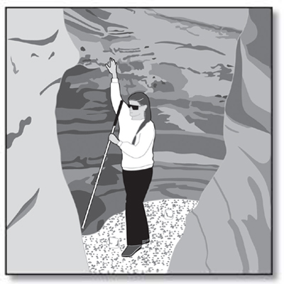
Figure 137—Protruding object requirements do not apply to natural features, such as caves in undeveloped areas.
Openings in Trail Surfaces
Openings are gaps in the surface of a trail. Gaps include slots in a drainage grate and spaces between the planks on a puncheon, bridge, or boardwalk. Openings that are big enough to allow wheels, cane or crutch tips, or shoe heels to drop through or get stuck are hazards that shouldn't exist in pedestrian routes. Openings up to a half of an inch (13 millimeters) across are permitted in trail surfaces. Place elongated openings more than a quarter of an inch wide with the long dimension perpendicular or diagonal to the primary direction of travel (figure 138).
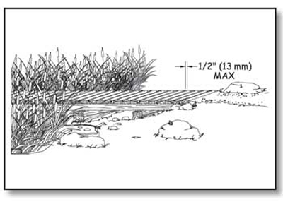
Figure 138—The requirements for openings that are perpendicular to the direction of travel on trail surfaces, such as boardwalk decking.
If there is a condition for an exception, openings less than three-fourths of an inch (19 millimeters) across are allowed. This deviation allows the use of boardwalk decking that needs more than ½-inch (13-millimeter) -wide spacing between the planks to permit expansion and to allow water to drain. If even the three-fourths of an inch deviation is not enough, General Exception 1 allows achieving trail surface opening requirements to the extent practicable if a condition for an exception is present.
Trail Facilities
To comply with the Architectural Barriers Act of 1968 (ABA) and Section 504 of the Rehabilitation Act of 1973, trail facilities such as tent pads and platforms, camp shelters, pit toilets, viewing areas, and similar structures for trail users that are provided along trails—even trails that are not accessible— must be designed to comply with the applicable provisions in FSORAG, except that slopes not steeper than 1:20 (5 percent) are allowed if necessary for drainage of unpaved surfaces that aren’t elevated above the natural ground.
The path of travel between trail facilities, as well as the path connecting them to a trail, must comply with FSTAG. These paths are not outdoor recreation access routes and are not required to meet the technical requirements for an outdoor recreation access route.
Trail facilities must be designed appropriately for the setting and in compliance with the applicable provisions in FSORAG to ensure that the facility can be used for its primary purpose by all hikers, including hikers with disabilities. For example, if a camp shelter is provided along a trail and its floor is above the ground, all hikers must be able to get inside the shelter. As explained in "Camp Shelters" of this guidebook, this can be accomplished by ensuring the camp shelter floor is 17 inches (430 millimeters) minimum to 19 inches (485 millimeters) maximum higher than the camp shelter space at the shelter entrance. This height allows someone using a wheelchair or other assistive device to transfer onto the floor of the shelter.
Requirements for all recreation facilities, including those that are commonly associated with trails, are contained in FSORAG and explained in "Applying the Forest Service Outdoor Recreation Accessibility Guidelines" of this guidebook.
Gates and Barriers on Trails
If gates or barriers are constructed to control access to trails, include openings wide enough to allow hiker passage. Refer to the FSTAG for the technical provisions for gates and barriers. These requirements are also explained in "Getting From Here to There—Outdoor Recreation Access Routes" of this guidebook.
Trailheads
To comply with the ABA and Section 504 of the Rehabilitation Act of 1973, ensure that each constructed feature provided at a trailhead complies with the applicable provisions of FSORAG and ABAAS. Requirements for trailhead features, such as parking spaces, toilets, water spouts, and campsites, are explained in "Applying the Forest Service Outdoor Recreation Accessibility Guidelines" of this guidebook.
Because trailheads are usually accessed by vehicle rather than only by hiking, at least one outdoor recreation access route must connect the following places at trailheads:
-
Accessible parking spaces or other arrival point
-
Starting point of the trail
-
Accessible outdoor constructed features, elements, spaces, and facilities within the trailhead
In alterations to existing trailheads, where there is a condition for an exception, the technical requirements for the outdoor recreation access route that are affected by the condition for an exception must be achieved only to the extent practicable. If elements, spaces, or outdoor constructed features are altered at trailheads but the path of travel isn't changed, an outdoor recreation access route isn't required.
Design Tip
New trail facilities must be accessible even if the trail doesn't comply with Forest Service Trail Accessibility Guidelines.
The Architectural Barriers Act of 1968 (ABA) requires that buildings comply with the applicable accessibility guidelines. This issue was clarified for Federal agencies when a complaint was filed with the U.S. Access Board against the U.S. Department of the Interior, National Park Service for installing an inaccessible toilet at 10,000 feet (3,048 meters) on Mt. Rainer. The petitioner was a paraplegic who was climbing the mountain with a sit-ski and ropes. He was not able to use the toilet that the rest of his party could use because it wasn't accessible. The U.S. Access Board found that the National Park Service was not in compliance with ABA that requires all new construction funded by Federal Executive agencies to be accessible. The National Park Service settled the complaint by replacing the toilet with an accessible model.
The Forest Service was cited by the U.S. Access Board after a complaint was filed about a pit toilet serving the trail at North Doublehead in New Hampshire. The toilet was constructed in 1972 after the 1968 passage of the ABA, but the toilet was not accessible. The Forest Service replaced the toilet with an accessible model.
It's really in the best interests of all organizations to ensure that all facilities—regardless of where they are located—are appropriate to the setting and are accessible. When accessibility is integrated into the design from the beginning, there's not much difference in cost. If the design of a facility that's already under construction must be changed to provide for accessibility, or if an inaccessible facility has to be replaced with an accessible facility at a later date, costs will be substantial.
To quote a hiker with a Northeast Passage hiking team that includes a diverse group of people (figure 139): "Hiking a trail is a challenge by choice; using a toilet is not a choice so it shouldn't be a challenge."
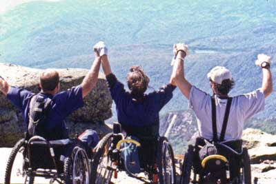
Figure 139—Three members of the Northeast Passage hiking team celebrate their conquest of Mount Lafayette in New Hampshire. Photo credit: Northeast Passage, Durham, NH
Trailhead Signs
People have made it clear that they want information about trails, including length, grade, and so forth, so that they can make their own decisions about which trail is appropriate for the amount of time they have available, the people in their group, and the type of hike they are interested in pursuing. Therefore, when new information signs are provided at trailheads for newly constructed or altered trails, include at minimum the following information:
-
Trail name
-
Length of the trail
-
Type of surface on the trail
-
Typical and minimum trail tread width
-
Typical and maximum trail grade
-
Typical and maximum trail cross slope
-
Height of any major obstacles, such as boulders, in the trail tread
-
A statement that posted information reflects the condition of the trail when it was constructed or assessed, including the construction or assessment date
The requirement for posting the construction and trail assessment date is because tree blowdowns, flooding, or other events can make trails designed and constructed to FSTAG standards temporarily inaccessible until maintenance crews can clear the obstruction. If the date is posted, people will be able to evaluate the likelihood that the trail remains in the posted condition. For instance, people may know that a major storm has occurred since the conditions were posted or may estimate the likelihood that vegetation may have overgrown the trail since the condition was evaluated.
Where more extensive trail information such as an aerial map of the trail and related facilities is provided, identify the location of specific trail features and obstacles that do not comply with FSTAG's technical requirements and include a profile of the trail grade.
If materials, such as maps, brochures, fee envelopes, and so forth, need to be obtained from or filled out at a sign or kiosk, design the sign or kiosk to display the materials within the standard reach ranges of a person in a wheelchair in accordance with ABAAS, section 308, as explained in "Reach Ranges and Operability Requirements" of this guidebook.
Locate trailhead information signs centered at the back of a 30- by 48-inch (760- by 1,220-millimeter) -minimum clear floor or ground space. Do not allow the clear space to overlap the trail width but it may overlap a resting space or passing space. The slope of the clear space is not allowed to be more than 1:20 (5 percent) in any direction.
Overview of FSTAG Implementation Process
Now that you have learned about the extent of application, general exceptions, and the technical requirements, you may wonder how the whole process ties together. Use the following four easy steps and the handy process flowchart in the appendix to implement FSTAG on your trail design projects. Following this process will help you verify that the trail design complies with the technical requirements to the extent practicable, help you document how and where the technical requirements can, or cannot, be applied, and confirm that the character, trail class, and experience of the setting will not be changed. It also can be used as a field guide when locating or rerouting a trail.
Step 1: Determine the Applicability of FSTAG
After a decision has been made to design or alter a trail, three questions must be asked:
1. Does the work meet the definitions for new construction or alteration? Definitions are in "Understanding Trail Terminology" of this guidebook.
-
If yes,
2. Is the Designed Use "Hiker/Pedestrian"?
-
If yes,
3. Does the proposed trail connect to a trailhead or to a trail that substantially complies with FSTAG? (Trailhead is defined in "Understanding Trail Terminology.")
If the answer to any of these questions is no, FSTAG does not apply and no further analysis is required. The finding and reasons that FSTAG does not apply should be briefly documented and put in the project file. Figure 140 shows step 1. Even if compliance with FSTAG is not required, you should try to incorporate accessibility where opportunities exist and to the extent you can without changing the character of the setting and, therefore, the hiking experience.
If the answer to all three questions is yes, the designer moves to step 2.
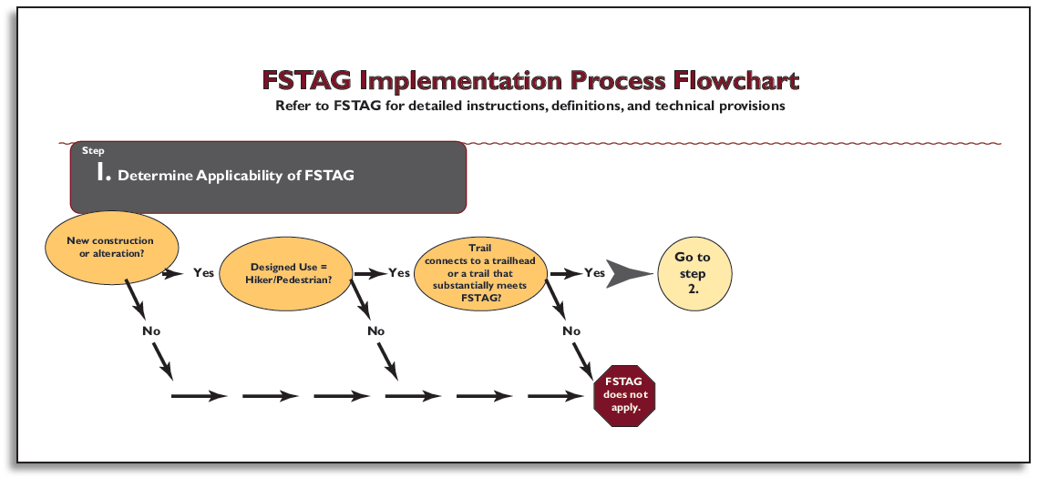
Figure 140—Step 1 of the Forest Service Trail Accessibility Guidelines implementation process. (For a larger image please click here.)
Design Tip
Evaluate your trail design for Forest Service Trail Accessibility Guidelines (FSTAG) compliance using on-the-ground layout.
In order to work through steps 2, 3, and 4 of the implementation process, lay out a proposed trail alignment on the ground and conduct the evaluation as you walk the flag line. Base the review and analysis required in these steps on actual field conditions, rather than relying only on topographic maps.
Step 2: Identify the Presence of Limiting Factors
This step addresses the condition criteria accepted by the U.S. Access Board for identifying when extreme environmental barriers allow the use of General Exception 2. These barriers are defined in the first four limiting factors in FSTAG, section 7.2.2.1 "Determining Impracticability" and are explained in "General Exceptions in FSTAG" of this guidebook. The sequence for identifying the limiting factors may vary and does not need to be done in the order illustrated in the process flowchart.
Work your way through the process flowchart by asking four questions, each related to one of the limiting factors. The first question will be explained in detail to serve as an example for the other three.
Does the combined trail running slope (grade) and cross slope exceed 1:2.5 (40 percent) for a continuous distance of 20 feet (6 meters) or more?
Construction Tip
Choose a method to measure the running slope.
There are a number of ways you can measure running slope. You can perform an informal survey between obvious trail slope breaks with a hand level, survey rod, and measuring chain (figure 141). You can use a digital level (figure 142). You can also perform a more detailed trail assessment such as the universal trail assessment process developed by Beneficial Designs (http://www.beneficialdesigns.com/).
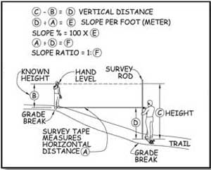
Figure 141—Surveying trail grade with a hand level.
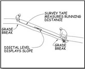
Figure 142—Surveying trail grade with a digital level.
If not, FSTAG may still apply, so you should consider Design Tip the next limiting factor. A continuous distance means a sustained running slope (grade) without rest areas or more moderate slopes. If the alignment can be relocated to get a more moderate slope, this limiting factor doesn't apply.
If the combined slope exceeds 1:2.5 (40 percent) for a continuous distance of 20 feet (6 meters) or more, document the length of trail that exceeds the technical requirements for slopes, the location of the area, and your data source (field survey, clinometer, and so forth). Keep this information for use in step 4.
Next, determine whether a condition for an exception exists that permits a deviation from the technical requirements for slope. If there is no condition for an exception, FSTAG may still apply, so you should proceed to the next limiting factor.
If a condition for an exception does exist, document the length of trail affected by the condition for an exception, what exception applies, and the location of the area.
Next, consider whether the combined trail running slope (grade) and cross slope is so excessive that it is impracticable for the entire trail to comply with the technical requirements. If so, FSTAG does not apply to this trail at all and no further review or analysis is required. Document the reason for the determination, retain it in the project file, and notify the U.S. Access Board, as explained in "Documenting Exceptions and Notifying the U.S. Access Board About Exemptions" of this guidebook.
Finally, consider the end section of trail between the limiting factor and the trailhead or another trail that substantially complies with FSTAG. Is there a prominent feature between the end of the trail and the limiting factor? If so, consider constructing the section of trail between the end of the trail and the prominent feature in compliance with the technical accessibility requirements. Doing so is not required, but it is often good management and good customer service.
Design Tip
Use a rule of thumb to estimate firmness and stability.
What sort of surface is firm and stable? If the answer to both of the following questions is yes, the surface is probably firm and stable.
-
Could a person ride a narrow-tired bicycle across the surface easily without making imprints? (Bicycle tires are similar to the large rear wheels of a wheelchair.)
-
Could a folding stroller with small, narrow plastic wheels containing a 3-year-old be pushed easily across the surface without making imprints? (The stroller's wheels are similar to the front wheels of a wheelchair.)
While this method for determining firmness and stability isn't scientifically accurate, it has proven to be effective.
Work your way through the other three limiting factors the same way. The design tips may help you.
Is the surface neither firm nor stable for 45 feet (14 meters) or more?
Is the trail tread width 12 inches (227 millimeters) or less for a distance of at least 20 feet (6 meters)?
Is there an obstacle at least 30 inches (760 millimeters) high extending across the full width of the trail?
Design Tip
Determine when trail width is a limiting factor.
Measuring the existing trail width is easy—just use a measuring tape to get the side-to-side distance of the narrowest stretch of trail. Figuring out whether that width can be changed may be a little more difficult. The trail may be less than 12 inches (227 millimeters) wide, but if you can widen it in its current location or move the trail alignment to an area where it can be wider, the limiting factor doesn't apply.
If you find a limiting factor where a condition for an exception applies, there's no reason to evaluate the trail beyond that point for successive limiting factors unless the rest of the trail connects to a trailhead or a trail that substantially complies with FSTAG. Just look at the section of trail between the limiting factor or prominent feature and the trailhead or connecting trail. Figure 143 shows step 2.
If there are no limiting factors that would prevent compliance with FSTAG, proceed to step 3.
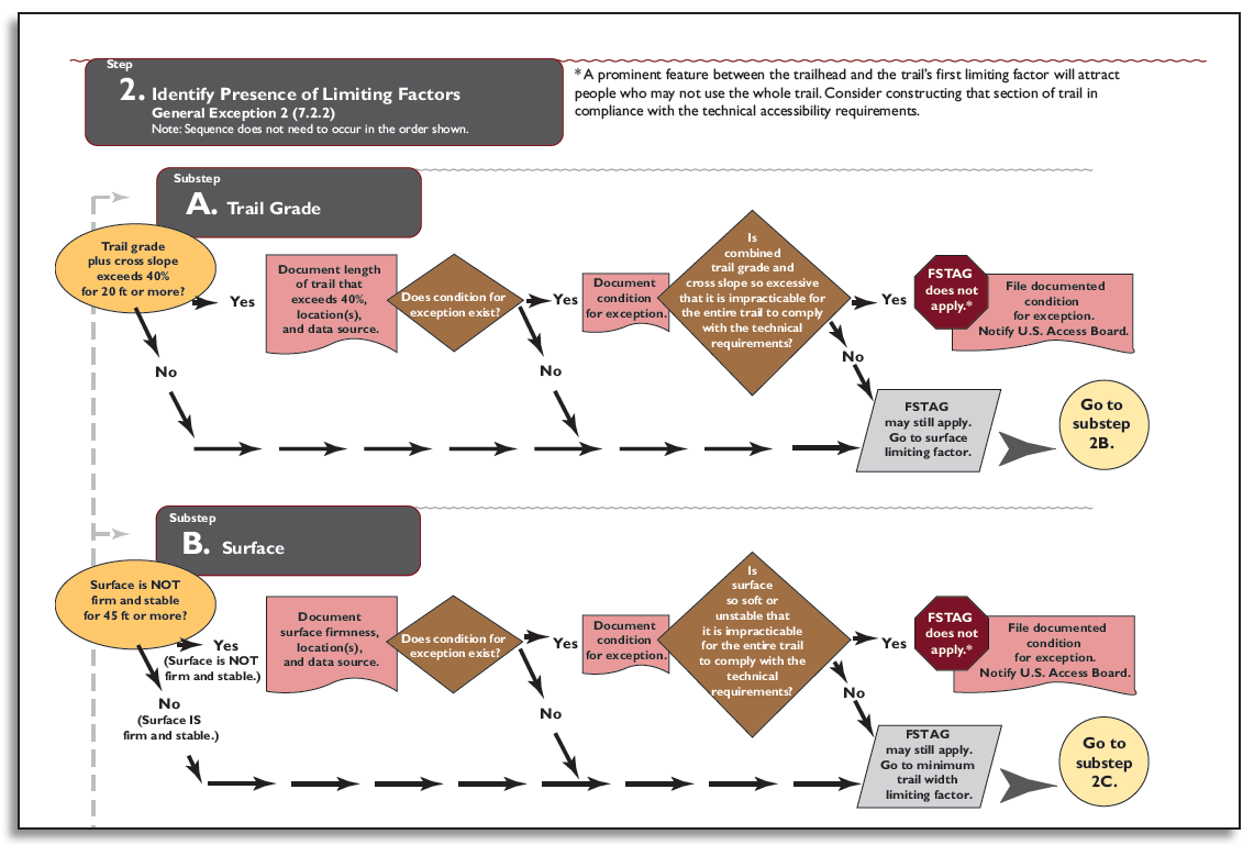
Figure 143—Step 2 of the Forest Service Trail Accessibility Guidelines implementation process. (For a larger image please click here.)
Step 3: Apply the Accessibility Provisions
This step involves looking at FSTAG, sections 7.4.1 through 7.4.8, which contain the technical requirements for trail grade, cross slope, resting interval, surface, clear tread width, passing space, tread obstacles, protruding objects, and openings.
This summary and the process flowchart don't contain everything you need to know about trail design requirements. Refer to FSTAG for detailed instructions, definitions, conditions for an exception, accessibility provisions, and allowable deviations.
A series of questions with yes or no answers is asked for each of the technical requirements, similar to step 2. Use the trail running slope (grade) as an example.
First, look at the existing conditions on the ground and determine whether the trail alignment complies with the required running slopes of a maximum of 1:20 (5 percent) for any distance, 1:12 (8.33 percent) for up to 200 feet (61 meters), 1:10 (10 percent) for up to 30 feet (9 meters), and so forth. Could a change in trail alignment facilitate meeting the requirement? If not, does one of the conditions for an exception prevent compliance? If the trail alignment complies with the required slope or there is no condition for an exception, compliance with the technical requirement for trail grade is required. If the grade requirement can't be met because of a condition for an exception, measure and record the length of trail that will deviate from the technical requirement. Then consider how the running slope could be adjusted to get as close as practicable to the requirement. Record what the slope will be on that section of the trail and proceed to the next technical requirement.
Each technical requirement is addressed in a similar manner. Make a determination for every technical requirement: either compliance is required or deviations are permitted. Be sure to measure and record the length of the trail on which each deviation from a particular technical requirement will occur. Figure 144 shows step 3. After you work through all the technical requirements, proceed to the last step.
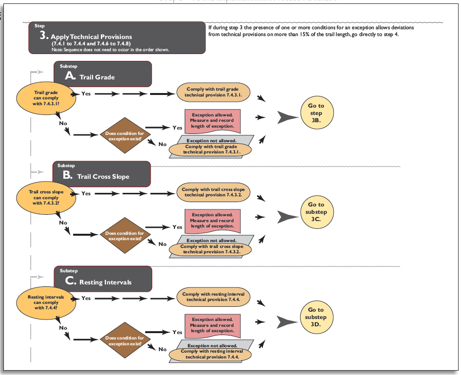
Figure 144—Step 3 of the Forest Service Trail Accessibility Guidelines implementation process. (For a larger image please click here.)
If at any point during step 3 you find that the recorded length of the trail that contains deviations adds up to 15 percent or more of the total trail length, proceed directly to step 4.
Step 4: Calculate Cumulative Deviation Percentage
This final step addresses the suggested objective criteria for identifying when extreme or numerous environmental barriers allow the use of General Exception 2. These barriers are defined in the five limiting factors in FSTAG, section 7.2.2.1.
Design Tip
Apply the process.
Figure 145 helps illustrate how to apply the process by calculating cumulative deviations and considering a prominent feature. The drawing shows that:
-
Deviations occur on more than 15 percent of the trail because 15 percent of 950 feet equals 142.5 feet (15 percent of 290 meters equals 43.5 meters), but the deviations total 216 feet (66 meters).
-
The trail does not have to comply with the guidelines.
-
The first point of deviation occurs 400 feet (122 meters) from the trailhead and the vista is only 250 feet (76 meters) from the trailhead. It may be appropriate to construct the trail in compliance with the guidelines from the trailhead to the vista.
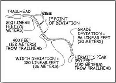
Figure 145—This trail schematic illustrates how to determine where the trail must comply with Forest Service Trail Accessibility Guidelines.
Add the measurements of permitted deviations from step 3. If these deviations occur on 15 percent or more of the total trail length, FSTAG doesn't apply to the trail. Figure 146 shows step 4.
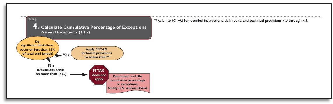
Figure 146—Step 4 of the Forest Service Trail Accessibility Guidelines implementation process. (For a larger image please click here.)
The FSTAG Implementation Process Flowchart
FSTAG must be applied before initiating new construction or altering any National Forest System trail with a "Designed Use" of "Hiker/Pedestrian." Figure 147 distills the implementation process into a quick reference that provides easy reference as you work through the process. A detailed FSTAG implementation process flowchart is available in the appendix.
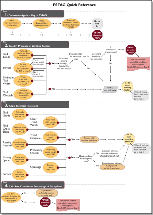
Figure 147—Quick reference for the Forest Service Trail Accessibility Guidelines implementation process. (For a larger image please click here.)
Before applying FSTAG, you'll need to:
-
Analyze existing conditions, including potential opportunities and constraints (National Environmental Policy Act analysis).
-
Identify and verify the desired Trail Class for the trail or trail segment.
-
Identify and verify the "Designed Use" of the trail or trail segment.
If you have questions about applying any of the above information, please contact your region's recreation accessibility coordinator. Current contact information is available at http://www.fs.fed.us/eng/toolbox/acc/documents/coord.htm#leader.
User Comments/Questions
Add Comment/Question