Getting to the Water—Beach Access Routes
Beach access routes allow pedestrians to get across the beach so they can play, swim, or participate in other beachrelated [sic] activities. A beach access route is a continuous unobstructed path that crosses the surface of the beach and provides pedestrian access to the water. Section 6 of FSORAG explains the requirements for beach access routes. Because beach access routes and outdoor recreation access routes perform similar functions, the requirements are similar.
Beaches are grouped into three general types:
-
Tidal beaches (figure 113)
-
River beaches (figure 114)
-
Lake, pond, and reservoir beaches (figure 115)

Figure 113—The high tide level at a coastal beach.
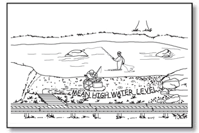
Figure 114—The mean high water level at a river.

Figure 115—The normal recreation water level at a lake.
Beach access routes must extend from an outdoor recreation access route or other beach entry point to the high tide level at tidal beaches, mean high water level at river beaches, and the normal recreation water level at lake, pond, and reservoir beaches.
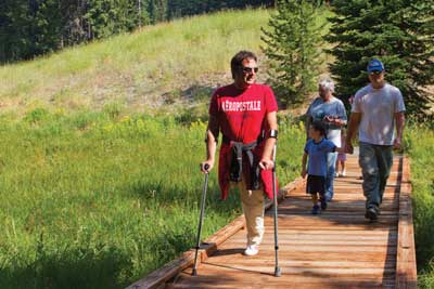
Beach access routes are required when dune crossings, stairways, or ramps leading from boardwalks to the beach are constructed or altered; when parking facilities, pedestrian routes, toilet facilities or bathing facilities that serve the beach are constructed or altered; or when a beach nourishment project is undertaken. They must coincide with or be located in the same area as other pedestrian access to the beach. Employ universal design wherever possible so that all visitors use the same route to get to the water (figure 116).
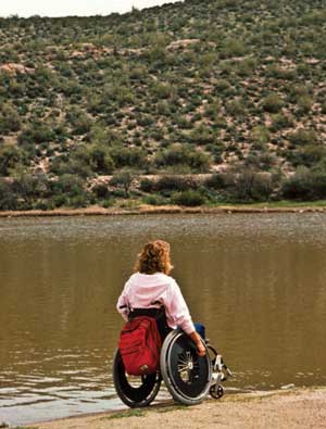
Figure 116—Everybody ought to be able to get to the beach.
When beach access routes are required, provide them for each half mile of managed shoreline. However, the number of beach access routes doesn't have to exceed the number of pedestrian beach access points that are provided. Beach access routes are not required where pedestrian access to the beach is not allowed. Beach access routes associated with beach nourishment projects are only required up to an expenditure of 20 percent of the costs of the beach nourishment project.
Removable beach access routes can be moved to a protected storage area during storms and other periods when the routes are subject to damage. Removable beach access routes are not required to comply with the slope and resting interval technical requirements. Use temporary beach access route surfaces as necessary where restrictive permits are required in coastal and shoreline areas where seasonal tides or high flows would remove a permanent structure, or in areas where the beach erodes or builds up each season, quickly turning a permanent beach access route into a hazard. Vehicular access or access provided by an assistive device isn't an acceptable temporary beach access route.
Design Tip
Extend beach access routes to a reasonable point on the beach.
Access to the water at tidal beaches will vary considerably depending on geographic locations because the difference between low and high tides will vary from place to place. For example, a beach in Alaska may experience tidal differences of up to 30 feet (9 meters); beaches in Florida will have much smaller differences between the tides. The high tide mark is a reasonable location to stop constructed features; they are much more likely to wash out below this point. The same general guidance applies to mean high water level at rivers and the normal recreation water level at lakes.
In some locations, it may make sense to continue the beach access route below the mean high water level or normal recreation water level. In locations with significant variations in water level through the recreation season, visitors appreciate extended access routes where they can be constructed (figure 117).
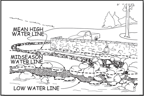
Figure 117—Some beach access routes are partly inundated every year.
Exceptions to the Guidelines That Apply to Beach Access Routes
When a condition for an exception prohibits full compliance with a specific technical requirement on a portion of a beach access route, that portion of the beach access route must still comply with the requirement to the extent practicable. (See "Using the Conditions for an Exception in FSORAG.") Document the reason that full compliance wasn't achieved and file it with the project records for the construction or alteration project.
Notifying the U.S. Access Board About Exemptions
Infrequently, an entire beach access route must be exempted from the technical requirements because extreme or numerous conditions for exemptions make it impractical to provide a route that meets the requirements. In these cases, document the reason for the exemption, the date of the decision, and the names of the individuals who made the decision. Retain documentation with the records for the construction or alteration project. Notify the U.S. Access Board of the determination and the reason for that decision. Contact information for the U.S. Access Board is available at http://www.access-board.gov/
The U.S. Access Board has drafted a form that may be used to document and submit an exemption decision. The form will be available at http://www.access-board.gov/guidelines-and-standards/recreation-facilities/outdoor-developed-areas when the U.S. Access Board final guidelines are published.
Surface and Clear Tread Width on Beach Access Routes
A beach access route must have a firm, stable surface, and have a clear tread width of 60 inches (1,525 millimeters) minimum.
Slopes and Resting Intervals for Beach Access Routes
Running slope, also referred to as "grade," is the lengthwise slope of a beach access route, parallel to the direction of travel. Sections of beach access route of any length are allowed to have a running slope ratio of up to 1:20 (5 percent grade) (see figure 37). Steeper terrain may make this slope difficult to achieve. Many visitors can negotiate steeper slopes for short distances, so running slopes up to 1:12 (8.33 percent) are permitted for up to 50 feet (15 meters), and running slopes of up to 1:10 (10 percent) are permitted for up to 30 feet (9 meters). To ensure that the beach access route isn't designed as a series of steep segments, no more than 15 percent of the total length of the beach access route may exceed a slope of 1:12 (8.33 percent), as shown in table 4.
Table 4—Beach access route running slope and segment length.
| Running Slopes on Beach Access Routes | Maximum Length of Segment Between Resting Intervals | |
|---|---|---|
| Steeper than | But not Steeper than | |
| 1:20 (5 percent) | 1:12 (8.33 percent) | 50 feet (15 meters) |
| 1:12 (8.33 percent) | 1:10 (10 percent) | 30 feet (9 meters) |
Cross slopes—the side-to-side slope of a beach access route—are not allowed to exceed 1:33 (3 percent, see figure 37). When the surface is paved or is built with boards, the cross slope is not allowed to be steeper than 1:48 (2 percent).
Resting intervals are relatively level areas that provide an opportunity for people to catch their breath before continuing along the beach access route. These intervals are required between each segment of the beach access route any time the running slope exceeds 1:20 (5 percent). A resting interval must be at least 60 inches (1,525 millimeters) by 60 inches (1,525 millimeters).
The slopes of a resting interval are not allowed to exceed 1:33 (3 percent) in any direction. When the surface is paved or is built with boards, the slope is not allowed to be steeper than 1:48 (2 percent) in any direction.
Tread Obstacles on Beach Access Routes
Tread obstacles on a beach access route must not be more than 1 inch (25 millimeters) high. When the surface of the beach access route is paved or is built with boards, tread obstacles must not be more than a half of an inch (13 millimeters) high. Where possible, ensure obstacles on beach access routes are separated by at least 48 inches (1,220 millimeters) so people who use wheelchairs can maneuver around the obstacles.
Openings in Beach Access Routes
Openings are gaps in the surface of a beach access route. Gaps include spaces between the planks on a boardwalk and drainage holes in temporary or permanent surfaces. Openings that are big enough to allow wheels, cane or crutch tips, or shoe heels to drop through or get stuck are hazards that shouldn't exist in pedestrian routes. Openings up to a half of an inch (13 millimeters) wide are permitted. Place elongated openings more than a quarter of an inch wide with the long dimension perpendicular or diagonal to the primary direction of travel (see figure 44).
Protruding Objects on Beach Access Routes
Outdoor accessibility guidelines define protruding objects as constructed features such as signs that extend into the clear width area of a beach access route or resting interval and are between 27 inches (685 millimeters) and 80 inches (2,030 millimeters) above the travel surface. Do not allow constructed features to extend more than 4 inches (100 millimeters) into the clear width area (see figure 45). Constructed features that extend into the travel way of a beach access route from the side or from overhead can be hazardous to people who are paying more attention to their companions than the travel route, as well as to people who are blind or have low vision.
Accessibility guidelines do not consider natural elements such as tree branches and rock formations to be protruding objects. Provide and maintain clearance from natural elements around beach access routes in accordance with your unit's standards; keep in mind overhanging hazards to people who are blind or have low vision or are not focused on the route ahead.
Elevated Dune Crossings
An dune crossing that is elevated or has a slope that exceeds 1:20 (5 percent) that is part of a beach access route must have handrails and edge protection (figure 118). Locate handrails continuously along both sides of the dune crossing at a height of 34 inches (865 millimeters) to 38 inches (965 millimeters) above the walking surface. Ensure the handrails are easy to grip and comply with all the other requirements in ABAAS, section 505. Provide a curb or barrier directly under the handrail that would prevent a 2-inch (50-millimeter) sphere on, or up to 2 inches (50 millimeters) above, the dune crossing surface from rolling under the handrail. The clear width of elevated dune crossings may be narrower than the rest of the beach access route, but must be at least 48 inches (1,220 millimeters). Resting intervals are not required on elevated dune crossings. Consider including resting intervals similar to those for outdoor recreation access routes if the elevated crossing is steeper than 1:20 (5 percent).
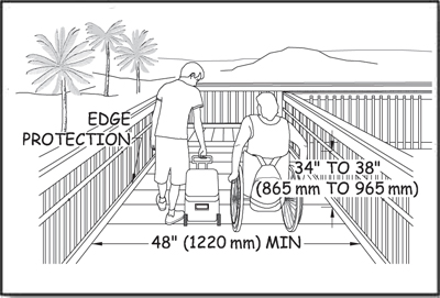
Figure 118—The requirements for width, handrails, and edge protection onan elevated beach access route.
Gates and Barriers on Beach Access Routes
If gates or barriers are constructed to control access to beach access routes, include openings wide enough to allow hiker passage. Refer to the FSORAG for the technical provisions for gates and barriers. These requirements are also explained in "Getting From Here to There—Outdoor Recreation Access Routes" of this guidebook.
User Comments/Questions
Add Comment/Question