Product Description
Tactile maps are a great aid for people who are blind or partially sighted, helping them to orient themselves and to plan routes. Using Touch Mapper, you can easily create custom outdoor maps for any address of your choice. You can either order an affordable 3D print (basic map for 35 euros, about USD40), or 3D-print the map yourself at no charge.
What is the map like?
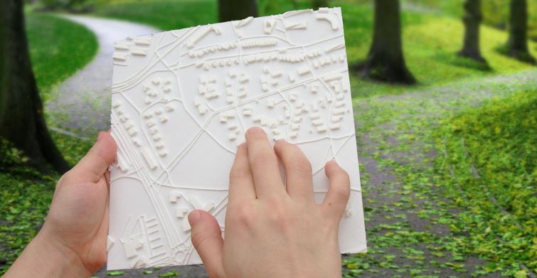
Touch Mapper tactile maps are optimized for clarity and the practical needs of people who are visually impaired; they are not a true to life version of the area. The map contains the following:
-
Roads of all size. Pedestrian roads are higher than others, because they are more important for the blind.
-
Buildings
-
Railways
-
Waterbodies (with wavy surface, but narrow streams as lines)
-
Selected address (or entered coordinates) marked with a cone
-
North-east corner marked to indicate correct orientation
If you are not sure if the maps suit your needs, a local association of visually impaired is probably happy to help.
Where does map data come from?
Touch Mapper uses OpenStreetMap data. Although this is usually an excellent source, accuracy of the maps cannot be guaranteed. The most common problem is missing buildings. You may use the 3D preview to verify if the map will fit your requirements. If important features are missing, you may freely add them to OpenStreetMap using the Edit button at the top. Unfortunately commercial map data sources like Google Maps can't be used, because they don't allow required type of access to their data.
Why print tactile maps?
Tactile maps can benefit many different user groups.
-
People who are blind or partially sighted: better orientation and route planning
-
Outdoor tourist attractions: better service for customers who are blind or partially sighted
-
Public areas such as parks and playgrounds: tactile maps can help visitors who are blind or partially sighted to enjoy the park more independently.
-
Orientation and mobility specialists: to help clients to build a mental map of an area more easily
Printing maps in multiple parts
If a single map isn't large enough to cover the required area, you can make multiple prints and lay them side by side on a flat surface. To do this, select "Advanced options" and then "Print a part of multipart map". In this mode, there will be no borders around the edges of the map. Also, there appears arrow buttons for adjusting the selected area by 100% (that is, map's diameter) in each direction, which makes it easy to select adjacent areas for the maps.
About Touch Mapper
My name is Samuli Kärkkäinen. I created Touch Mapper after learning about the challenges faced by people who are blind or partially sighted when travelling independently, and realizing how 3D printing combined with freely available map data can help. I have integrated Touch Mapper with Playful Pixels' 3D printing service to make buying the maps as easy and affordable as possible.
Information about new features and relevant events are posted to Facebook and Twitter.
I want to make Touch Mapper as good as possible, and user feedback is key in that. If you have any questions or suggestions for improvement, please email us.