Exhibit Design Relating to Low Vision and Blindness: Tactile Mapping for Cultural and Entertainment Venues
Talking Three-Dimensional Models for Way-finding
In contrast to raised-line maps, touchable models provide more spatially accurate information, but also have some limitations, and are never portable. Models are probably more intuitive to use for an inexperienced or young blind user as compared to tactile maps, which require additional layers of abstract thinking. People generally find it easier to draw a spatial analogy between the physical world and a scale model than to comprehend a raised-line map of the same space. I speculate this is because tactile map map-reading involves transposing three-dimensional space into a 2D format by taking an imaginary slice through the world. This seems like a more cognitively involved mental function than understanding that a model is a miniature version of reality. On the other hand, scale models show information about building volumes and details that are irrelevant to a tactile reader who is planning a walking route, because they don’t need to know, for example, how tall a building is in order to walk there at ground level.

A few museums and public places offer tactile models that visitors are allowed to touch, such as the outdoor bronze model at the Getty Center in Los Angeles (see fig. 8). Given the complexity and the irregular shapes of the Getty, the model does an admirable job of presenting an overall sense of the layout. There are some Braille labels on the buildings and a clear You Are Here marker. Richard Meier’s Getty’s model is really a beautiful object, set at a prominent spot on the campus, and is useful for orientation, but probably not very helpful for way-finding, because there is no descriptive information that would help blind travelers to actually navigate from the model to a various destinations on campus.
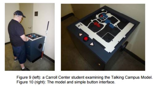
In another example, the Carroll Center for the Blind has recently installed a talking tactile campus model. Students at the center hear audio descriptions about each element that they touch (see figures 9 and 10). This talking map is specifically intended for use in wayfinding and orientation, and was designed in collaboration with staff at the Carroll Center to ensure that the talking model would serve as a useful tool in familiarizing new students with the layout of buildings, pathways, and noteworthy landmarks for way-finding, like bus stops, low walls and railings. Information is provided in a series of audio layers that are accessed by continuing finger contact with a single part of the model. These layers are: element name (for example, “Centre Street”, “Bus Stop”); location (in respect to the current position in front of the model); functional description; and locations of doors for entering and exiting buildings. In comparison to non-interactive models like the one at Getty Center, it’s clear that users need on-demand descriptions of model elements to really understand what they are looking at. Just as audio-tactile displays like TTT and IVEO1 bring raised-line graphics to life through a multi-sensory approach, for a visually impaired individual experiencing the model through touch sense, this kind of audio labeling provides the crucial key to comprehension.
1 IVEO is a trademark of ViewPlus Inc. of Corvallis, OR. TTT refers to Talking Tactile Tablet, an audio-tactile device from Touch Graphics, Inc. of New York, NY.
User Comments/Questions
Add Comment/Question