Exhibit Design Relating to Low Vision and Blindness: Tactile Mapping for Cultural and Entertainment Venues
Portable tactile maps
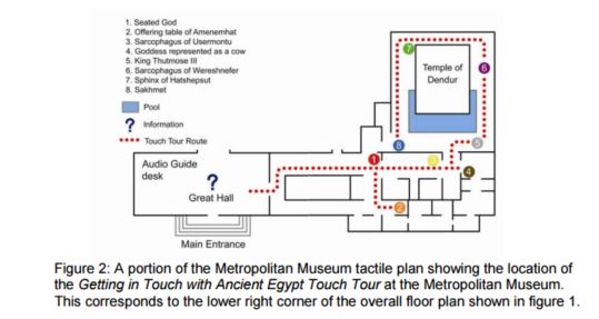
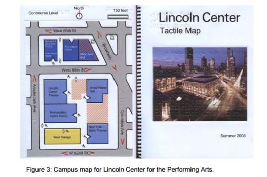
The most obvious way to provide spatial information for visually disabled visitors is to offer portable raised-line and textured (tactile) maps that can be carried and consulted en route. These are accessible representations of building and campus layouts available to visitors on demand. Usually, these maps are provided in multi-page booklets. Ideally, they include information presented in several ways to ensure legibility by the largest possible audience. See, for example, map of the Getting in Touch with Ancient Egypt Touch Tour at the Metropolitan Museum (fig. 2) and the Lincoln Center for the Performing Arts Tactile Map (fig. 3). These maps include large print and Braille text, raised lines, and texture fills to show spatial arrangements, and a legend to identify destinations, and the meanings of symbols.
A number of techniques have been used to produce portable tactile maps, including vacuum forming three-dimensional shapes onto pre-printed vinyl sheets (e.g., the Lincoln Center map), embossing on paper, and “capsule paper”, where you draw with a black pen on special paper, then heat up the paper to make the black lines puff up. All maps that you carry share one big deficiency: by definition, they lack a fixed point of reference, so there can be no You Are Here marker. Anecdotal evidence suggests that users generally find it difficult to develop a strong sense of their current position in the context of a map while in motion, and without access to visual landmarks and signage that can be matched to things on the map. Nevertheless, well made tactile maps are useful, especially when the spaces shown are simple, and rendered in a very limited palate of tactile features (Blades & Spencer, 1987). Experienced tactile map designers try to restrict themselves to using no more than three distinct line types, three different textures and four or five point symbols, such as stairs and building entrances (Rowell and Ungar, 2003). Other rules of thumb include restrictions on crowding, and proper use of Braille labeling (Edman, 1992).
User Comments/Questions
Add Comment/Question