Trail Study Sites
An Access Board solicitation for potential playground study sites yielded numerous responses for trail work as well. An accessibility coordinator for the Wisconsin State Parks offered us an opportunity not far from the Forest Products Laboratory, at Governor Dodge State Park in Dodgeville, Wisconsin--to extend an accessible beach path and to attempt to stabilize two short sections of a severely eroded bridle path.
Beach Path
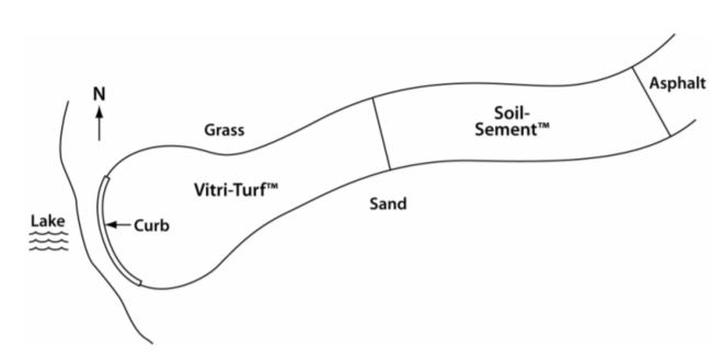
Our prototype test location for the SEWF concept on trails was an accessible beach path to Cox Hollow Lake. The existing path was 1.2-m- (4-ft-) wide blacktop asphalt extending 50 m (165 ft) from accessible parking to the beginning of the sand beach, 30 m (100 ft) from the water. Our task was to provide accessibility over the sand to the water, retaining the aesthetic quality of the area (National Center on Accessibility 2003).
Discussions with the park staff provided insight to the usage of the beach path. The desire was for park users to be able to maneuver a wheelchair directly to the water's edge, where they could access the beach and a boat landing (Fig. 1). Another consideration was the proximity of the path to the beach volleyball area. The SEWF surfaces were originally developed for use as impact-sensitive playground surfaces. Thus, their impact behavior was considered much more forgiving than that of an asphalt path.
Layout of the path across the beach was sloped so that the edge of the path would not hold water. Park personnel were concerned that sand would wash or get kicked over the path surface, which would decrease accessibility and increase maintenance requirements. Slope along the upper edge was a minimum of 1%. Nearer the waterline the slope of the path increased to a maximum of approximately 5% for the final few meters (feet). The amount of waterline fluctuation was considered minimal at this beach because of the proximity of water control structures.
Figure 1-Schematic plan of Governor Dodge State Park Cox Hollow beach path site (not to scale).
We first lowered and leveled the existing sand surface to a depth of 0.06 m (2.4 in.) (Fig. 2). Any stones and vegetation near the waterline were removed. Within 1.5 m (5 ft) (horizontal distance) of the waterline, the stability of the sand was deemed inadequate for supporting the SEWF. We removed 0.1 m (4 in.) of sand in this area and replaced it with 20 mm (3/4 in.) of angular stone to provide a well-drained and stable base, which would also reduce the amount of scour from wave action on the lake. The work crew consisted of employees of the park, the Wisconsin Department of Natural Resources, and the USDA Forest Service.
A lightweight landscaping geotextile fabric was placed on the sand and drainage rock. Handfuls of sand were thrown on the fabric to keep the wind from blowing it out of place. The geotextile fabric bonded to the SEWF and improved overall stability of the surface layer.
Bridle Path
Both bridle path sections were remote sites that required the use of hand tools for surface preparation. The surfaces were prepared by removing large rocks and woody forest debris.
One site consisted of two parallel ruts approximately 0.1 to 0.2 m (4 to 8 in.) deep and 0.2 to 0.3 m (8 to 12 in.) wide. The ruts were within 1 m (3 ft) apart on a 15% to 20% slope. Native soil was exposed along the ruts. The soil was firm with little loose soil or unstable rock.
The other site was a 3-m (12-ft) wide section on a bridle trail with a 20% to 25% slope leading to a level wash that carried water during heavy rains for very short periods. The primary objective was to stabilize the soil from the erosive forces of horse hooves and water running across the wash.
User Comments/Questions
Add Comment/Question